
The only substantially unexcavated medieval Islamic capital city in Asia — 14 km² of mosques, palaces, stepwells, and pilgrimage shrines across a Gujarat Sultanate urban landscape frozen since the Mughal conquest of 1535 CE, dominated by the sacred basalt summit of Pavagadh Hill rising 830 metres above the plain.
At a glance
Champaner-Pavagadh Archaeological Park in the Panchmahal district of Gujarat, inscribed on the UNESCO World Heritage List in 2004, preserves two overlapping heritage layers on a dramatic landscape: the sacred Hindu and Jain pilgrimage hill of Pavagadh, occupied since at least the 8th century CE, and the fully planned medieval Islamic capital of Champaner built by Sultan Mahmud Begada between approximately 1484 and 1535 CE — a city abandoned within 50 years of its construction when the Mughal Emperor Humayun captured it, and never substantially rebuilt, leaving the original urban plan of streets, gates, mosques, palaces, granaries, and water systems remarkably legible on the ground. The site is exceptional precisely because most of its structures remain unexcavated, making it an active archaeological landscape rather than a static open-air museum.
Key facts
- UNESCO designation: World Heritage Site 2004 (criteria iii, iv)
- Location: Panchmahal district, Gujarat, India — approximately 45 km north-east of Vadodara
- Area: approximately 14 km² within the Archaeological Park
- Principal builder: Sultan Mahmud Begada (r. 1459–1511 CE), Gujarat Sultanate
- Peak period: c. 1484–1535 CE as Sultanate capital
- Key monument: Jama Masjid of Champaner (c. 1513 CE) — the finest pre-Mughal mosque in India
- Sacred summit: Pavagadh Hill (830 m) — Kalika Mata Temple, active Hindu pilgrimage site year-round
- Managing authority: Archaeological Survey of India (ASI)
History
The Pavagadh hill was a sacred site and strategic fortress from at least the 8th century CE, when the Chavda dynasty — the earliest historical rulers of Gujarat — founded the first settlement of Champaner at the base of the hill, naming it after a minister called Champa. The hill fortress passed through several dynasties and became a Rajput stronghold under the Khichi Chauhans, who held it into the 15th century.
The transformation of Champaner into an imperial capital began in 1484 CE, when Sultan Mahmud Begada of the Gujarat Sultanate captured the Pavagadh fortress after a siege reportedly lasting 20 months. Mahmud Begada — who reigned for 52 years, the longest of any Gujarat sultan — immediately began construction of an entirely new capital city on the plain below the hill, conceived as an ideal Islamic city with the Jama Masjid at its centre, surrounded by residential, administrative, and commercial quarters enclosed within monumental walls and gates.
The city was built in a hybrid architectural style — Gujarat Sultanate architecture — that blended Gujarati Hindu and Jain stone-carving craft traditions with the spatial requirements of Sultanate Islamic architecture: pointed arches and domes executed with the intricate carved ornament of local workshops. The result is architecturally unique in the Indian subcontinent.
The city’s imperial career lasted barely 50 years. In 1535 CE, the Mughal Emperor Humayun captured Champaner during a Gujarat campaign, ending its status as a capital. Without the maintenance that imperial investment provided, the city was gradually abandoned, its buildings subsumed by vegetation and soil accumulation. Pavagadh hill remained a continuous pilgrimage destination, but the valley city fell into ruin and was largely forgotten by historians until systematic ASI investigation in the 20th century. The UNESCO inscription in 2004 catalysed international conservation attention.
What you see
The Jama Masjid of Champaner (c. 1513 CE) is the centrepiece of the park and the masterpiece of Gujarat Sultanate mosque architecture. Its prayer hall of eleven bays and five aisles, two slender flanking minarets unusual in pre-Mughal mosque design, and extraordinary jali (perforated stone latticework) screens in the façade arches make it the most cited pre-Mughal mosque in India. The integration of minarets, jali screens, and cusped arch profiles in a single composition is without precedent in earlier Indian mosque architecture.
The Kevda Masjid (Pandanus Mosque), named for the pandanus trees around it, retains a single minaret and fine carved stone decoration. The Nagina Masjid (Gem Mosque), smaller and highly ornate, has the finest surviving interior carved stone mihrab niche in Champaner. Several further mosques of varying scale are dispersed across the city plan, each with individual architectural character.
The Helical Stepwell (Vav) demonstrates the integration of water infrastructure and architectural ambition characteristic of the Gujarat tradition: an unusual spiral design departing from the standard rectilinear stepwell type, with carved stone columns and brackets at each landing.
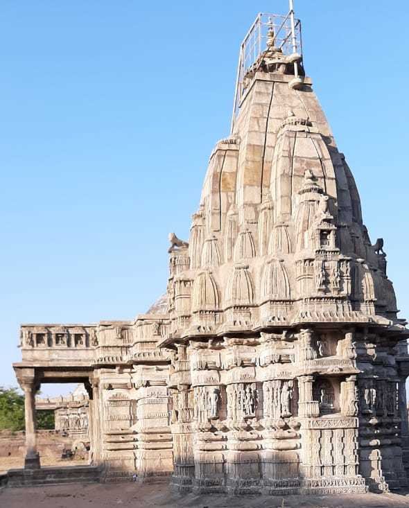
Pavagadh Hill is accessible by ropeway (cable car) or by a stepped path passing through Jain temples on the hillside before reaching the Kalika Mata Temple at the summit — an active Hindu shrine dedicated to the goddess Kali, whose medieval sanctum carries an Islamic-influenced superstructure added during the Sultanate period, creating one of the most unusual hybrid religious buildings in India. The city walls and monumental gates allow the original urban circuit to be traced on the ground.
Practical information
- Open: Daily, sunrise to sunset (ASI monuments); Kalika Mata Temple year-round with extended Navratri hours
- Entry: ASI ticket required; reduced rates for Indian nationals; separate ropeway ticket for Pavagadh summit
- Best season: October–March (cool and dry); avoid April–June (40 °C+)
- Navratri: September–October — very large pilgrimage crowds; book accommodation well in advance
- Photography: Permitted at external areas; restrictions inside active religious spaces
- Nearest city: Vadodara (Baroda), ~45 km — full hotel range, airport (VAD), main-line rail
Getting there
The nearest major transport hub is Vadodara (Baroda), approximately 45 km south-west. Vadodara has an airport (VAD) with connections to Mumbai, Delhi, and other major Indian cities, and lies on the Mumbai–Delhi main railway line. From Vadodara, taxis and auto-rickshaws can be hired for the approximately 1-hour drive to Champaner; regular bus services run from Vadodara ST Bus Stand to the Champaner/Pavagadh area. The town of Halol (~12 km from Champaner) provides closer bus and shared jeep connections. No direct train service reaches Champaner town.
Nearby
- Vadodara (Baroda): 45 km — Laxmi Vilas Palace, Maharaja Fateh Singh Museum, Sayaji Baug gardens
- Rani ki Vav, Patan: ~130 km north — UNESCO-inscribed 11th-century stepwell, the finest in India
- Sun Temple, Modhera: ~140 km north — 11th-century Solanki-dynasty temple with extraordinary carved kund (step-tank)
- Ahmedabad: ~130 km north — UNESCO World Heritage City, historic walled old town, international airport
Sources
- UNESCO World Heritage Centre — Champaner-Pavagadh Archaeological Park (no. 1101)
- Archaeological Survey of India — official site documentation
- Wikipedia — Champaner-Pavagadh Archaeological Park
- Michell, G. & Shah, S. — Champaner-Pavagadh: A medieval city and a sacred hill, Mapin Publishing, 2011
Find it on the map
See this place and what’s around it →📷 Become a Cultural Heritage Online photographer
Share your photos of places: they stay published under your name as the author. The more they're seen, the more you get noticed — and soon a contest will reward the most appreciated photos.
Log in or sign up free to add a photo