Locmariaquer Megalithic Ensemble
At the southern tip of the Gulf of Morbihan, three extraordinary Neolithic monuments cluster within a few hundred metres of each other — including the Grand Menhir Brisé, the largest single stone ever erected by human hands: 20 metres tall, 280–330 tonnes, quarried 4 km away, requiring an estimated 3,000–4,000 workers simultaneously. UNESCO World Heritage Site 1979.
At a glance
In the village of Locmariaquer at the southern tip of the Rhuys Peninsula in the Gulf of Morbihan (Breton: “little sea”), southern Brittany, three remarkable Neolithic monuments grouped within a few hundred metres constitute one of the most important megalithic ensembles in the world. The centrepiece is the Grand Menhir Brisé — the largest single stone ever erected in Neolithic Europe and possibly the largest monolith ever raised by human hands anywhere before the invention of modern machinery. Now fallen and broken in four pieces, it originally stood approximately 20–21 metres tall and weighed an estimated 280–330 tonnes. Part of the Gulf of Morbihan, Carnac and related megalithic sites UNESCO inscription (1979).
Key facts
- Grand Menhir Brisé: Originally ~20–21 m tall, ~280–330 tonnes — largest monolith ever erected in Neolithic Europe
- Date: c. 4200–3300 BC (Neolithic)
- Transport: Quarried ~4 km away; estimated 3,000–4,000 workers needed simultaneously
- Three monuments: Grand Menhir Brisé + Table des Marchands passage tomb + Er Grah tumulus
- Extraordinary discovery: The Grand Menhir was deliberately broken c. 3500 BC; its fragments used to cap three separate monuments across the Morbihan
- UNESCO WHS: 1979 (as part of Gulf of Morbihan ensemble)
- Status: French national monument; open to visitors year-round
History
The Grand Menhir Brisé was quarried from an orthogneiss granite outcrop approximately 4 km from its present location. The transport of a single block of this mass — before the wheel, before draught animals capable of such loads, in a landscape of soft coastal ground — required an estimated 3,000–4,000 people working simultaneously with log rollers, wooden sledges, and rope: the largest single transport operation documented in European prehistory. The stone was erected around 4000 BC, apparently standing for only a few centuries before falling — possibly toppled by an earthquake — and breaking into its four present pieces.
The most extraordinary chapter in Locmariaquer’s history was revealed in 1983 by Brittany archaeologists: the capstones of the Table des Marchands passage tomb here, the Gavrinis passage tomb on its island in the Gulf of Morbihan, and the Er Grah tumulus nearby are all fragments of a single stone — the Grand Menhir Brisé itself. The enormous menhir was deliberately broken sometime around 3500–3000 BC, and its fragments transported and placed as capstones of three separate megalithic monuments across the Gulf of Morbihan. The upper surface of each fragment carries carved imagery: the Gavrinis capstone bears cattle figures and a crook, while the Table des Marchands capstone shows a large bovid and chevrons — images carved on the menhir before it was broken. This deliberate redistribution of the broken stone — ritually transforming one enormous monument into parts of three others — is one of the most extraordinary acts documented in European prehistory.
What you see
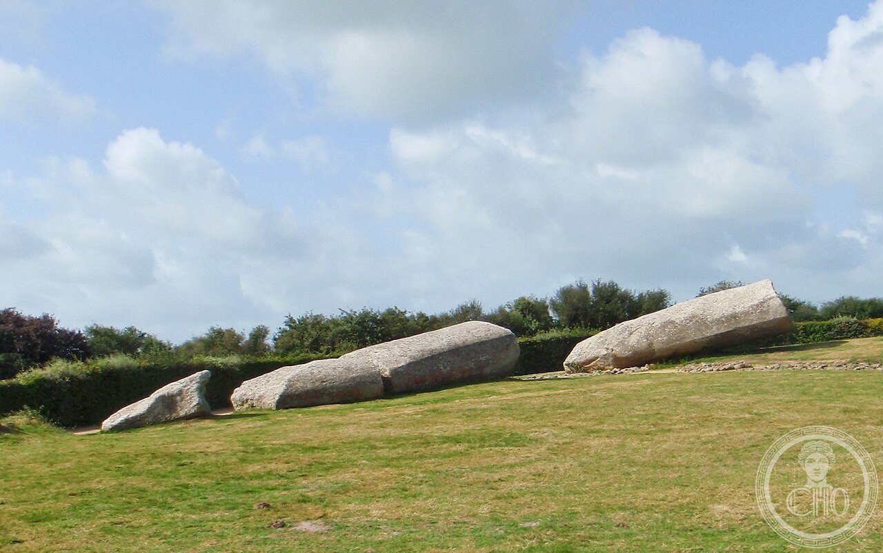
The Grand Menhir Brisé today lies in four broken pieces in an open field managed by the Centre des monuments nationaux. The largest fragment is approximately 12 metres long. When erect it would have been visible from approximately 20 km across the flat Gulf of Morbihan. The stone’s texture is distinctive — the orthogneiss granite has a layered, slightly schisted appearance different from the local stones of the surrounding countryside, a visible reminder that it was brought from elsewhere at enormous effort. Some of the carved imagery on the stone’s surface — the bovid figures and sheaf-like compositions — is still legible in raking light.
The Table des Marchands passage tomb, a few steps away, is accessible by guided visit. Its passage leads to a rectangular burial chamber whose rear orthostat carries a large carved composition — rows of shepherd’s crooks or axe-blades (interpretation varies) superimposed on an earlier pastoral image. The capstone above, seen from inside, is the fragment of the Grand Menhir Brisé, its carved bovid visible on the interior face. The Er Grah tumulus, a few hundred metres along the shoreline, has been partially excavated; its stone kerbing is visible.
Practical information
- Status: French national monument; managed by Centre des monuments nationaux
- Entry: Fee applies for the Table des Marchands interior and guided access to the Grand Menhir Brisé enclosure
- Opening: Year-round (hours vary by season; check CMN website)
- Guided visits: Table des Marchands interior accessible by guided tour only
- Combined tickets: Locmariaquer monuments + Gavrinis ferry + Carnac combinations available in season
- Photography: Permitted
Getting there
Locmariaquer is 30 km south-west of Vannes in the Morbihan department of southern Brittany. By car: D781 from Vannes toward Auray, then D28 south to Locmariaquer. Parking available at the monument entrance. By public transport: Vannes is served by TGV from Paris (~2h30); buses run from Vannes to Locmariaquer (check regional schedules). The monument is within walking distance of the Locmariaquer village centre.
Nearby
- Gavrinis (4 km by ferry from Larmor-Baden): The most elaborately carved Neolithic passage tomb in Europe; the Gavrinis capstone is a fragment of the Grand Menhir Brisé
- Carnac (15 km): World’s largest megalithic alignment — 3,000 standing stones in parallel rows
- Vannes (30 km): Medieval walled town, Morbihan archaeological museum with outstanding Neolithic collections
- Gulf of Morbihan boat tours: Seasonal tours of the 40-odd islands of the gulf, passing megalithic sites inaccessible by land
Sources
- Wikipedia: Locmariaquer megaliths
- Centre des monuments nationaux: monuments-nationaux.fr
- Cassen, S. et al. (2009): Fabrication et utilisation des stèles au Néolithique; study of the er Grah menhir fragmentation
- Burl, A. (1985): Megalithic Brittany, Thames and Hudson
- Scarre, C. (ed., 2002): Monuments and Landscape in Atlantic Europe, Routledge
Find it on the map
See this place and what’s around it →📷 Diventa un fotografo di Cultural Heritage Online
Condividi le tue foto dei luoghi: restano pubblicate con la tua firma come autore. Più vengono viste, più ti fai conoscere — e presto un concorso premierà le foto più apprezzate.
Accedi o registrati gratis per aggiungere una foto