Monemvasia — The Medieval City on a Sea Rock
A volcanic rock rising 100 metres from the Aegean Sea, connected to the Peloponnese mainland by a single 200-metre causeway, concealing an entire medieval Byzantine town on its southern face — invisible from every angle except through its single gate, and never taken by direct assault in 1,500 years.
At a glance
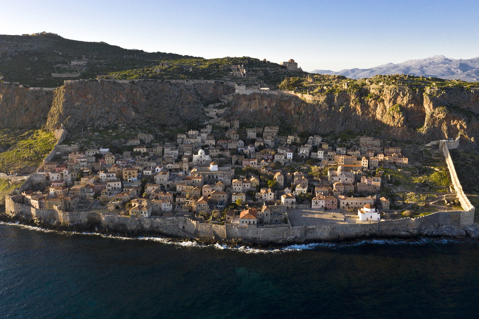
Monemvasia sits on the southeastern tip of the Peloponnese, an isolated volcanic sea-rock that reads from the mainland as an uninhabited island. The entire medieval town — cobblestone alleys, Byzantine churches, Venetian palaces, Ottoman mosques — clings to the rock’s southern face, completely hidden from view. Founded in 583 AD by mainland Greeks fleeing Slavic invasions, it grew into one of the most strategically impregnable and commercially important cities of the medieval Mediterranean. The name itself means “single entrance” in Greek: one narrow gate in a high wall separates the causeway from the town.
Key facts
- Founded: 583 AD — population fled mainland Slavic invasions to the sea-rock
- Medieval fame: Malmsey (Malvasia) wine — the most expensive wine in medieval Europe, named after Monemvasia
- Rulers: Byzantine Empire → Despotate of Morea → Venice → Ottoman Empire → Venice → Greece (1822)
- Upper town (acropolis): Deserted; Byzantine Governor’s Palace partially intact
- Hagia Sophia: 12th-century Byzantine church on cliff edge — the most dramatically sited Byzantine church in Greece
- Current population: Approximately 50 permanent residents in the lower town
- Strategic record: Never taken by direct assault in over 1,500 years of continuous occupation
History
In 583 AD, as Slavic tribes swept across the Peloponnese, the mainland population sought refuge on the uninhabited volcanic rock three kilometres off the coast. They built a wall across the narrow land connection, fortified the cliff edge, and established a community that would endure for more than fourteen centuries. The rock’s geometry — high vertical cliffs on three sides, the town invisible from any approach — made it not merely defensible but essentially impregnable. Byzantine armies, Frankish crusaders, Catalan mercenaries, and Ottoman forces all failed to take it by storm; the few times Monemvasia changed hands, it was through blockade, famine, or negotiation, never assault.
Between the 12th and 16th centuries Monemvasia was one of the busiest trading ports of the eastern Mediterranean. The sweet fortified wine produced in the surrounding Laconian vineyards — known in medieval Europe as Malmsey or Malvasia, the name itself a corruption of “Monemvasia” — commanded the highest prices of any wine in the medieval European market and was traded as far as England and Flanders. The town passed between Byzantine, Venetian, and Ottoman control multiple times; each period left its architectural layer in the lower town, from Byzantine churches to Venetian loggias to Ottoman mosques converted from churches. After Greek independence in 1822, the town declined; by the mid-20th century it was nearly abandoned. Restoration of the lower town as a heritage site began in the 1970s and continues today.
The upper town (acropolis), reached by a steep path from the lower town, was the military and administrative centre. Its Byzantine Governor’s Palace, the cisterns that allowed the population to withstand long sieges, and the tiny 12th-century church of Hagia Sophia — perched on the cliff edge with a view across the entire Laconian coast — are the most significant surviving monuments on the plateau. The upper town is deserted today and dramatically atmospheric.
What you see
The lower town is a dense labyrinth of medieval urban fabric: cobblestone alleys often less than two metres wide, vaulted passages connecting neighbourhoods at different levels of the rock face, stone houses built directly into the cliff. The main street runs east–west along the southern base of the rock; the Cathedral of Christ in Chains (Elkomenos Christos), an 11th-century Byzantine church with a later Venetian facade, dominates the main square. Most visible from the sea are the Venetian walls and the great gatehouse — the single entrance — through which every person and every cart that ever entered the city passed.
The upper town is reached through the lower town’s north gate and a steep rocky path. The silence and desolation of the acropolis contrasts sharply with the activity below. Hagia Sophia, the 12th-century Byzantine church built on the highest accessible point of the rock, has a single apse and a surviving mosaic fragment; its cliff-edge position, with a sheer drop to the sea on one side and a panoramic view of the Peloponnese coast on the other, makes it one of the most memorable Byzantine architectural experiences in Greece.
Practical information
- Access: The lower town is car-free; park on the mainland side of the causeway (free car park) and walk across
- Opening hours: The lower town is open continuously; the upper town (acropolis) is accessible year-round via the path from the lower town (no formal hours)
- Entry: No admission fee for the lower or upper town; individual churches and small museums may charge a nominal fee
- Best time: Spring (April–May) and autumn (September–October) for mild temperatures and fewer crowds; summer is crowded and hot
- Accommodation: Several small boutique hotels and guesthouses within the lower town — some of the most atmospheric accommodation in Greece
Getting there
Monemvasia is approximately 340 km south of Athens by road (3.5 hours via the Corinth–Tripoli–Sparta route). KTEL buses connect Athens (Kifissos terminal) to Monemvasia with one or two services daily (journey approximately 5.5 hours). The nearest airport is Kalamata (approximately 180 km / 2 hours by road); Athens International Airport (Eleftherios Venizelos) is the primary international gateway. There is no rail connection. Parking is on the mainland side of the causeway.
Nearby
- Mystras — UNESCO World Heritage Byzantine fortified city, approximately 90 km northwest; late Byzantine frescoes and palaces
- Epidaurus — ancient Greek theatre with near-perfect acoustics, approximately 200 km north
- Sparta — modern city over the ancient Spartan site, approximately 85 km northwest
- Cape Maleas — dramatic cape at the southernmost tip of the middle Peloponnese “finger”, approximately 60 km south
Sources
- Kalligas, H. A. Byzantine Monemvasia: The Sources. Monemvasia: Akroneon, 1990.
- Armstrong, P. (ed.) Monemvasia Research Project. British School at Athens, 2006.
- Wikipedia contributors. “Monemvasia.” Wikipedia, The Free Encyclopedia. Accessed 2026.
- Greek Ministry of Culture and Sports — official site listing for Monemvasia Castle.
Find it on the map
See this place and what’s around it →📷 Diventa un fotografo di Cultural Heritage Online
Condividi le tue foto dei luoghi: restano pubblicate con la tua firma come autore. Più vengono viste, più ti fai conoscere — e presto un concorso premierà le foto più apprezzate.
Accedi o registrati gratis per aggiungere una foto