
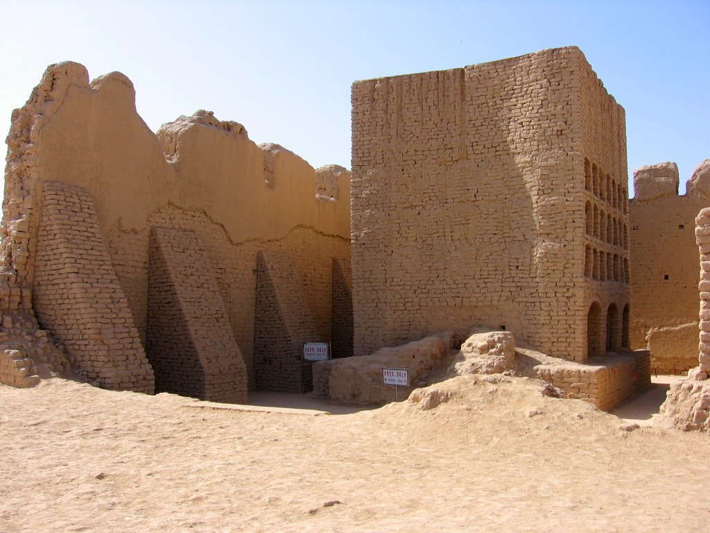
The largest mudbrick city ruins in the world by area — the capital of the Turfan oasis kingdom, a cosmopolitan Silk Road city where Buddhist monasteries, Manichean temples, Nestorian churches, and Islamic mosques coexisted within 4.5 km² of sun-dried brick walls preserved by extreme desert aridity.
At a glance
Forty-five kilometres east of Turpan city in the Xinjiang desert, the ruins of Gaochang — known as Khara-Khoja in Uyghur — cover approximately 4.5 km², making them the largest known mudbrick city ruins in the world by area. The outer city wall, built from sun-dried mudbrick, forms a roughly rectangular perimeter of approximately 5.4 km; within it lies an inner city wall, and within that the palace-city or imperial precinct. The extreme aridity of the Turpan Depression has preserved mudbrick walls to heights of 8–11 metres over 2,000 years, and the ruins of a Buddhist monastery complex retain walls, columns, and a large stupa in remarkable condition. Gaochang is inscribed as part of UNESCO Silk Roads World Heritage Site (2014).
Key facts
- Period: c. 1st century BC (Han garrison) through 14th century AD
- Area: Approximately 4.5 km² — largest mudbrick city ruins in the world by area
- Outer wall perimeter: Approximately 5.4 km; walls preserved to 8–11 metres height
- UNESCO: Inscribed 2014 as part of Silk Roads: Routes Network of Chang'an-Tianshan Corridor
- Location: −154 metres below sea level in the Turpan Depression, second-lowest land surface on Earth
- Religious plurality: Buddhist, Manichean, Nestorian Christian, and Islamic sites all identified within the city
- German excavations: 1902–1914, approximately 150 tonnes of objects removed to Berlin (now Museum of Asian Art)
History
Gaochang's origins lie in a Han Dynasty Chinese garrison established around 1 BC to control the Turfan oasis on the northern Silk Road. By the 4th century AD a local dynasty of Han descent, the Qu dynasty, had established an independent kingdom here that persisted for three centuries (499–640 AD), producing fine Buddhist art and maintaining diplomatic contacts with successive Chinese empires. The Tang Dynasty incorporated Gaochang as the prefecture of Xizhou in 640 AD, making it a major administrative centre of the Anxi Protectorate.
The most extraordinary chapter of Gaochang's history began in 850 AD when the Uyghur people — expelled from their Mongolian steppe homeland by the Yenisei Kirghiz — migrated westward and established the Uyghur Gaochang Kingdom. Under Uyghur rule, Gaochang became one of the ancient world's most cosmopolitan cities: Manicheanism (the Uyghurs' state religion from Mongolia), Nestorian Christianity, Buddhism, and eventually Islam coexisted within its walls. The kingdom was absorbed into the Mongol Empire in the early 13th century, and the city was finally abandoned around the 14th century as water supply systems collapsed amid political fragmentation.
What you see today
The ruins of Gaochang present one of the most haunting landscapes of the ancient world: a vast expanse of eroded mudbrick forms that still trace the full geometry of a great city across the desert floor. The outer wall is partially preserved at impressive height, and the three-zone plan — outer city, inner city, palace precinct — is clearly readable on the ground. The most intact structure is the Buddhist monastery complex in the outer city: walls of a monastic courtyard, a principal assembly hall, and a large stupa survive to considerable height, giving tangible sense of the building's original scale.
The German Turfan Expeditions of 1902–1914, led by Albert Grünwedel and Albert von Le Coq, removed the finest wall paintings, stucco sculptures, and manuscripts from Gaochang and the nearby Bezeklik caves to Berlin, where they are now held (partially destroyed in WWII bombing) in the Museum of Asian Art. The contrast between the stripped walls and the Berlin collection remains a source of diplomatic tension between China and Germany. The Xinjiang Museum in Ürümqi and the Turpan Museum display objects for visitors seeking the full archaeological context.
Practical information
- Distance from Turpan: 45 km east of Turpan city; accessible by taxi, tour, or hired car
- Entry: Admission fee charged; included in some Turpan area combination tickets
- Combine with: Jiaohe Ruins (10 km west of Turpan) and Bezeklik Thousand Buddha Caves (50 km northeast)
- Season: April–October; summer temperatures in Turpan regularly exceed 48°C — bring water and sun protection
- UNESCO context: The 2014 Silk Roads inscription covers both Gaochang and Jiaohe as key nodes in the corridor
Getting there
Turpan city is the base for visiting Gaochang. It is served by Jiaohe Grassland Railway Station (high-speed rail from Urumqi, approximately 30 minutes) and Turpan Jiaohe Airport with connections to Urumqi and major Chinese cities. From Turpan, Gaochang is 45 km east by road; taxis and tour buses run from the city centre. The Turpan area is a standard stop on the Xinjiang tourist circuit between Urumqi and Kashgar.
Nearby
- Jiaohe Ruins (Yarkhoto) — The world's largest earthen ancient city, carved from a plateau 10 km west of Turpan; UNESCO Silk Roads 2014
- Bezeklik Thousand Buddha Caves — Cave monastery with 77 chapels carved into a river cliff, 50 km northeast; finest paintings now in Berlin
- Flaming Mountains (Huoyan Shan) — Red sandstone mountains made famous by the Tang Dynasty novel Journey to the West, visible from Gaochang
- Turpan Museum — Major regional museum with Silk Road artefacts and mummies; in Turpan city
Sources
- Albert von Le Coq, Buried Treasures of Chinese Turkestan (1928) — account of the German Turfan Expeditions
- Valerie Hansen, The Silk Road: A New History, Oxford University Press, 2012
- UNESCO World Heritage inscription: Silk Roads — Routes Network of Chang'an-Tianshan Corridor (2014)
- Wikipedia: Gaochang
- Xinjiang Museum, Ürümqi — collection documentation for Turfan oasis sites
Find it on the map
See this place and what’s around it →
📷 Become a Cultural Heritage Online photographer
Share your photos of places: they stay published under your name as the author. The more they're seen, the more you get noticed — and soon a contest will reward the most appreciated photos.
Log in or sign up free to add a photo