
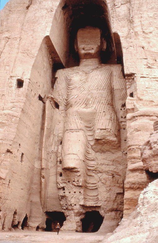

For 1,500 years two colossal Buddhas stood carved into a sandstone cliff in the Hindu Kush, the largest standing Buddhas in the world. In March 2001 the Taliban destroyed them both. UNESCO inscribed the empty niches the following year.
At a glance
The Bamiyan valley in central Afghanistan’s Hindu Kush contains one of the most significant concentrations of Buddhist heritage on the Silk Road: more than a thousand cave dwellings, monastic cells, and votive niches cut into a two-kilometre sandstone cliff, along with painted chamber ceilings of extraordinary quality. The valley’s visual centrepiece until 2001 was the two colossal standing Buddhas — Salsal (55 metres) and Shamama (38 metres) — carved directly from the living rock in the 6th century AD. The niches are empty now. UNESCO inscribed the entire cliff complex as a World Heritage Site in 2003, after the destruction, as a deliberate act of remembrance and to protect the remaining painted caves and carved rock features.
History
The two Buddhas were carved during the Gandharan cultural period, the larger (Salsal) dated to 554 AD and the smaller (Shamama) to 507 AD. The Bamiyan valley was a major node on the Silk Road linking China and Central Asia with India and the Mediterranean; pilgrims from across the Buddhist world travelled here. The Chinese monk Xuanzang documented his visit in 630 AD, describing the valley and the gold-decorated Buddhas. Their niches were originally painted in elaborate patterns of red, white, and blue; remnants of the pigment survive in sheltered areas of the cliff. The figures wore painted garments and may have held painted or gilded wooden features.
Islam reached the region in the 7th century. Over subsequent centuries, Bamiyan changed rulers repeatedly — Abbasid, Samanid, Ghaznavid, Ghurid, Mongol, Timurid, Mughal — but the Buddhas survived. Genghis Khan’s forces sacked the valley in the 13th century; the Buddhas stood. The Mughal emperor Aurangzeb reportedly ordered cannon fire at the figures in the 17th century; the faces were damaged, the bodies remained. When the Taliban took control of Afghanistan in the 1990s under Mullah Omar, the statues were initially left in place. In February 2001, Mullah Omar issued an edict declaring all non-Islamic statues idolatrous and ordering their destruction. A delegation of representatives from Muslim-majority countries including Saudi Arabia, Egypt, and Iran travelled to Kandahar to urge reconsideration. The Taliban rejected them.
The destruction began in early March 2001. Anti-aircraft guns and artillery had limited effect on the Buddhas’ scale; the Taliban then placed dynamite charges in holes drilled into the statues, supplemented with rockets and mines. The smaller Buddha was destroyed first, the larger required repeated detonations over several days. The Taliban filmed the process and distributed the recordings as propaganda. On 9 March 2001, both niches were empty. The rubble — hundreds of tonnes of sandstone — accumulated at the cliff base. Approximately 1,500 years of continuous existence ended in about two weeks.
UNESCO inscribed the Bamiyan Cultural Landscape and Archaeological Remains as a World Heritage Site in 2003 — deliberately after the destruction, citing the remaining cliff caves, painted chambers, and the historical significance of the niches themselves as heritage worthy of protection. Technical teams from TU Munich subsequently created detailed 3D laser scan reconstructions of both Buddhas from archive photographs and surface measurements. One proposal, backed by UNESCO and the Afghan government, would use original fragments cemented with lime mortar to partially reconstruct one Buddha in a technique called anastylosis; this project has not moved forward under the current Taliban government.
What you see
The cliff face runs for approximately 1.5 kilometres at the northern edge of the valley, rising to 130 metres. The two niches — arched recesses carved to follow the original figures’ outlines — are now empty cavities in the rock face. The larger niche (55 m) still shows traces of the original painting on its curved ceiling: fragments of red and orange pigment, geometric patterns, and what scholars identify as depictions of Sasanian and Kushan courtly scenes. The smaller niche retains more painted surfaces, including portions of a vaulted ceiling that may represent the oldest surviving oil paintings in the world — carbon-dated to 650 AD by Japanese researchers in 2008, using oil-based binder on the painted surfaces.
Immediately around the niches, and throughout the two-kilometre stretch of cliff, are more than a thousand artificial caves: monks’ cells, meditation chambers, communal spaces, and unfinished votive niches. Some retain original painted decoration. A number of the painted chambers were damaged by the Taliban using the caves as barracks and for target practice; others remain in reasonable condition. Archaeological survey continues, with UNESCO and the Aga Khan Trust for Culture among the active organisations.
Key facts
- Location: Bamiyan Valley, Afghanistan, 34.83°N 67.83°E — Google Maps
- Original Buddhas: Salsal (55 m, carved 554 AD) and Shamama (38 m, 507 AD); tallest standing Buddhas in the world at the time of their destruction
- Destroyed: March 2001 by Taliban; dynamite, rockets, anti-aircraft guns
- UNESCO WHS: 2003 (inscribed after destruction; “Bamiyan Cultural Landscape and Archaeological Remains”)
- Oldest oil paintings: Painted cave ceilings near niches, dated c. 650 AD by JAXA/Japanese researchers (2008)
- 3D reconstruction: TU Munich laser-scan reconstructions exist; no physical rebuild approved under current government
- Remaining features: 1,000+ rock-cut caves; painted chambers; carved niches; Silk Road archaeological layers
Practical information
- Access to Bamiyan requires travel through Afghanistan; check your government’s current travel advisory; many governments advise against all travel to Afghanistan
- The valley itself is reported as relatively peaceful compared to other regions; local guides are essential and assist with access to cave sites
- The cliff is walkable at base level; access to the upper caves requires climbing via internal staircases carved in the rock or external paths
- Altitude: Bamiyan sits at approximately 2,500 metres; acclimatisation from Kabul (1,800 m) is generally sufficient
- The site has no significant visitor infrastructure; plan self-sufficiently
Getting there
Bamiyan is approximately 240 km north-west of Kabul, historically reachable by road in 4–6 hours via the Shibar Pass or the Salang Tunnel route. A domestic flight service has operated intermittently between Kabul and Bamiyan. Given current political conditions, the practical access situation changes; the road through the central highlands passes through multiple administrative zones. Any visit should be arranged with a specialist organisation familiar with current conditions on the ground.
Nearby
- Band-e Amir National Park (75 km west) — Afghanistan’s first national park; six deep-blue lakes in the Hindu Kush, separated by natural travertine dams; one of Central Asia’s most dramatic natural landscapes
- Shahr-e Gholghola (2 km east of Bamiyan) — “City of Screams”; ruins of the 12th-century Ghurid citadel destroyed by Genghis Khan in 1221; legend says the defenders screamed so loudly the noise was heard for miles
- Kabul (240 km south-east) — the National Museum of Afghanistan holds Gandharan Buddhist sculpture; much of its collection was looted in the 1990s civil war and partially recovered
Sources
- Buddhas of Bamiyan — Wikipedia
- UNESCO World Heritage Centre: Bamiyan Cultural Landscape
- Bamiyan — Wikipedia
- Grenet, F. & others (2008) — Identification of oil-based binder in Bamiyan cave paintings; JAXA research team; published in Journal of Analytical Atomic Spectrometry
- Mullah Omar — Wikipedia
Find it on the map
See this place and what’s around it →📷 Become a Cultural Heritage Online photographer
Share your photos of places: they stay published under your name as the author. The more they're seen, the more you get noticed — and soon a contest will reward the most appreciated photos.
Log in or sign up free to add a photoIs this page about you?
This page is read by travellers and heritage enthusiasts who find it on Google. Tell us how you are connected to this place and we will take it from there.