Temple of Preah Vihear
A Hindu temple perched on the edge of a 525-metre cliff, Preah Vihear is considered by many scholars to surpass even Angkor Wat in the refinement of its bas-relief carving — and has spent decades at the centre of a sovereignty dispute between Cambodia and Thailand that briefly turned military in 2011.
At a glance
Preah Vihear stands at the northern edge of the Cardamom Mountains’ Dângrêk escarpment, on the Cambodia–Thailand border, commanding a sheer drop of 500 metres to the Cambodian plain below. The temple was built in stages from the 9th to the 12th centuries CE by successive Khmer kings, dedicated to the Hindu god Shiva, and constitutes one of the most dramatic architectural settings in all of Southeast Asia. Its orientation — unusually toward the north rather than the conventional sacred east — reflects its position at the cliff’s edge, with the staircase of sanctuaries descending the mountain over 800 metres. UNESCO World Heritage since 2008.
History
Construction began in the early 9th century under King Jayavarman II, the founder of the Angkorian empire, but the temple reached its present elaborate form under kings Rajendravarman II and Suryavarman I in the 10th and early 11th centuries, with later additions through the 12th century. Each successive Khmer ruler who invested in the site left architectural and epigraphic traces, making the temple a palimpsest of royal patronage spanning three centuries.
The temple transitioned from Hindu to Buddhist use as the Khmer religious landscape shifted, a common evolution across Khmer sites. It was largely abandoned after the decline of the Khmer Empire and lay partially forgotten until French archaeologists rediscovered and documented it in the early 20th century.
The sovereignty dispute between Cambodia and Thailand is among the most protracted heritage-related border conflicts in modern history. Both countries claimed the temple and the surrounding plateau. The International Court of Justice ruled in Cambodia’s favour in 1962, but the ruling left a small disputed area undefined. When UNESCO inscribed Preah Vihear in 2008, tensions escalated into military confrontation; troops from both sides exchanged fire near the temple in 2011, leaving casualties. A second ICJ ruling in 2013 reaffirmed Cambodian sovereignty over the temple and the promontory it stands on.
What you see
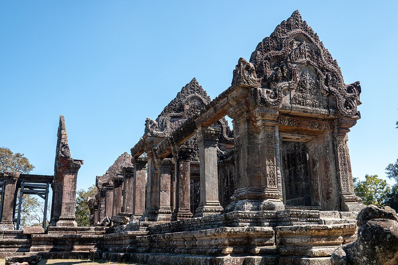
The temple’s plan is a linear sequence of five sanctuaries (gopuras) connected by paved causeways and naga balustrades, descending the cliff face over 800 metres. The path climbs from the lowest gate — approached from the Thai side, now restricted — to the main sanctuary at the cliff’s edge. Each successive gopura is more elaborately decorated than the one before; the effect is of a deliberately built climax.
The bas-relief carving at Preah Vihear is extraordinary. Scholars note that the quality of execution — particularly in the depiction of figures, mythological scenes, and floral decoration — is the finest in the Khmer artistic tradition, exceeding even the famous galleries at Angkor Wat in technical refinement if not in scale. The carvings on the pediments and lintels of the main sanctuary include scenes from Hindu mythology: the Churning of the Ocean of Milk, the battle of the gods and demons, and various manifestations of Shiva.
The cliff-edge location means the main sanctuary overlooks the Cambodian plain 500 metres below — a view that must have reinforced the temple’s function as a place of divine elevation, literally above the mortal world.
Cultural significance
Preah Vihear demonstrates the Khmer Empire’s ability to adapt monumental architecture to extreme topography, creating a religious experience inseparable from its dramatic natural setting. The temple’s unusual north-facing orientation, its 800-metre processional axis on the cliff, and the progressive elaboration of decoration toward the apex all represent a deliberate orchestration of the visitor’s experience — a concept of architectural narrative that anticipates modern ideas of experiential design by a thousand years.
In modern Cambodia, the temple is a potent symbol of national identity: its contested history, its ICJ validation, and its UNESCO status all converge to make it one of the most politically and culturally loaded heritage sites in Southeast Asia.
Key facts
- UNESCO WHS: Inscribed 7 July 2008 (Inscription No. 1224)
- Period: 9th–12th century CE; primary construction under Suryavarman I (r. 1002–1049)
- Dedication: Hindu temple to Shiva; later adapted for Buddhist use
- Elevation: 525 m above the Cambodian plain; cliff drop approximately 500 m
- Layout: 5 gopuras (sanctuary gateways) on a 800 m axis descending the cliff
- ICJ rulings: 1962 (Cambodia wins) and 2013 (Cambodian sovereignty reaffirmed)
- Military conflict: Cambodian–Thai border skirmish near the temple, 2011
- Coordinates: 14.3956° N, 104.6800° E
Practical information
- Access: From the Cambodian side (main access route); road from Sra Em town in Preah Vihear Province
- Condition: The temple is open to visitors; check current accessibility due to ongoing border-zone sensitivities
- Best season: November–April (dry season); roads can be difficult in the wet season
- Combined visit: Often paired with Koh Ker (126 km south), another Khmer site with a pyramid-temple
Getting there
From Siem Reap (330 km south), take the road north to Sra Em in Preah Vihear Province. The final stretch to the cliff is steep and requires a sturdy vehicle or a local transfer. A small visitor complex at the base manages access. The Thai side approach (via Kantharalak in Sisaket Province) requires crossing the international border and is subject to diplomatic conditions.
Nearby
- Koh Ker — 7-tier pyramid-temple (c. 921–944 CE), the short-lived Khmer capital, 126 km south; UNESCO WHS 2023
- Prasat Thom — the largest monument at Koh Ker, with a 36 m pyramid sanctuary
- Angkor — the Khmer imperial capital complex, 330 km south near Siem Reap; UNESCO WHS 1992
Sources
Find it on the map
See this place and what’s around it →📷 Diventa un fotografo di Cultural Heritage Online
Condividi le tue foto dei luoghi: restano pubblicate con la tua firma come autore. Più vengono viste, più ti fai conoscere — e presto un concorso premierà le foto più apprezzate.
Accedi o registrati gratis per aggiungere una fotoDo you manage this place?
This page is read by travellers and heritage enthusiasts who find it on Google. Keep it accurate — and make it work for you. Free for non-profit heritage institutions.