Stevns Klint
The cliff where the end of the age of dinosaurs is written in stone — Stevns Klint (a 17 km chalk cliff on the coast of Zealand, Denmark; inscribed UNESCO World Heritage 2014) preserves the world’s most accessible section of the Cretaceous-Paleogene (K-Pg) boundary — the thin dark layer of rock that marks the impact of the asteroid that killed the dinosaurs 66 million years ago.
At a glance
Stevns Klint (the most precisely Stevns single K-Pg boundary 66 million years iridium anomaly asteroid impact mass extinction fossil fish clay Chicxulub UNESCO heritage: the K-Pg boundary (the Cretaceous-Paleogene boundary; formerly called the K-T boundary for Cretaceous-Tertiary): 66 million years ago, an asteroid approximately 10-15 km in diameter struck the Earth at the site of what is now the Yucatán Peninsula, Mexico (the Chicxulub crater; discovered 1991 CE); the impact released energy equivalent to 100 teratons of TNT; the ejecta and dust blocked sunlight globally for months to years; the photosynthesis collapse killed the food chain; the result was the fifth mass extinction in Earth history (the Cretaceous-Paleogene mass extinction; approximately 75% of all species went extinct; the non-avian dinosaurs went extinct entirely); the K-Pg boundary is preserved in the geological record worldwide as a thin layer of rock containing anomalously high concentrations of the element iridium (iridium is extremely rare in Earth’s crust but common in asteroids; the iridium in the K-Pg layer worldwide came from the vaporized asteroid); Stevns Klint preserves the world’s most visually accessible and scientifically well-studied section of the K-Pg boundary — the thin dark “fish clay” (fiskeler in Danish) layer is visible at the cliff face at eye level and has been the subject of extensive scientific study since the 1970s — the most precisely Stevns single K-Pg boundary 66 million years iridium anomaly asteroid impact mass extinction fossil fish clay Chicxulub UNESCO heritage in any UNESCO world heritage site)).
Key facts
- The Iridium Anomaly and the Alvarez Hypothesis: the most precisely Stevns single 1980 Alvarez father son Berkeley California iridium anomaly 30-160 times normal K-Pg boundary asteroid impact hypothesis Nobel physics heritage — the scientific significance of the K-Pg iridium anomaly: in 1980 CE, physicist Luis Alvarez (Nobel Prize in Physics 1968) and his geologist son Walter Alvarez published a paper in Science magazine proposing that the K-Pg mass extinction was caused by a large asteroid impact; the key evidence was the iridium anomaly — the concentration of iridium in the K-Pg boundary layer at Stevns Klint (and at other sections worldwide) is 30-160 times higher than normal background levels; this iridium could only come from an extraterrestrial source (the Earth’s interior iridium is mostly locked in the core); the Alvarez hypothesis was initially controversial (many geologists favored volcanic causes for the extinction) but was confirmed when the Chicxulub impact crater was discovered in 1991 CE; the Stevns Klint section was one of the key sites used in the original Alvarez research
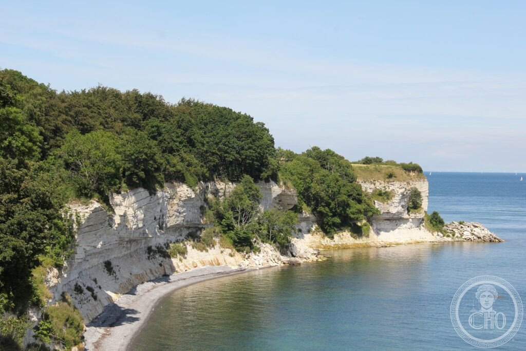
- The Fish Clay: the most precisely Stevns single fish clay fiskeler 1-3 cm dark pyrite marine mass mortality iridium concentration pyrite-rich anoxic sea heritage — the fish clay (fiskeler) at Stevns Klint (the thin dark layer marking the K-Pg boundary): the layer is 1-3 cm thick; dark grey to black; rich in pyrite (iron sulfide); full of the skeletal remains of fish and marine invertebrates (the name comes from the abundant fish teeth and bones in the layer); the darkness of the layer comes from the anoxic (oxygen-depleted) conditions in the sea immediately after the impact (the dust and debris from the impact darkened the sky and shut down photosynthesis; the marine algae that produce oxygen for the sea died; the sea became anoxic; the organic-rich dark sediment (the fish clay) was deposited in this anoxic sea immediately above the impact layer)
- GPS: 55.2700° N, 12.4400° E
History
The geology and human history of the cliff (the most precisely Stevns single Højerup church 1329 CE cliff erosion 1928 collapse choir sea Cold War museum military heritage: the human history of Stevns Klint: the chalk has been quarried for building material since the medieval period (the churches of Zealand, including Copenhagen’s oldest buildings, used Stevns chalk); the church of Højerup (built approximately 1329 CE; the small white medieval church at the top of the cliff at the village of Højerup) gradually approached the cliff edge as the cliff eroded; in 1928 CE, the choir of the church fell into the sea when the chalk beneath it collapsed; the nave and tower survived (the choir was rebuilt; the repaired church is still in use); during the Cold War, the Danish military built the extensive STEVNS FORT (Stevnsfort; now a museum) into the chalk of the cliff — the underground military installation (built 1952-1953 CE; used until 1990 CE) was designed to coordinate Danish naval defense of the Øresund channel against a Soviet naval attack; the Cold War museum inside the cliff is one of the most unusual in Scandinavia — the most precisely Stevns single Højerup church 1329 CE cliff erosion 1928 collapse choir sea Cold War museum military heritage in any UNESCO world heritage site)).
What you see
Site experience (the most precisely Stevns single StevnsKlint visitor centre Højerup church cliff walk fish clay K-Pg layer touch geology museum Cold War fort heritage: the main visitor approach: Stevns Klint Visitor Centre (Stevns Klint Geo Center; opened 2014 CE; the geological and cultural history of the cliff; the interactive K-Pg boundary exhibit; GPS: 55.275, 12.418; open May-October; DKK 120/adult); the cliff walk (the path along the top of the cliff; 4 km from the visitor centre to Højerup; the views of the Baltic Sea below; the cliff is 20-40m high); the key geological observation: the fish clay layer is visible at the base of the cliff (where the chalk cliff meets the beach; the dark 1-3 cm layer at the contact between the two white chalk units is the K-Pg boundary; it can be reached at low tide and touched; photographs against the layer to show the scale are the essential souvenir of a visit to Stevns Klint); the Højerup church (the eroded cliff; the reconstructed choir; the Baltic view from the churchyard) — the most precisely Stevns single StevnsKlint visitor centre Højerup church cliff walk fish clay K-Pg layer touch geology museum Cold War fort heritage in any UNESCO world heritage site)).
Practical information
- Getting there: Stevns Klint is 60 km south of Copenhagen (Copenhagen Airport (CPH): one of Northern Europe’s main aviation hubs); by public transport: S-tog (urban train) from Copenhagen Central Station to Køge (45 min; DKK 48; then bus 210 or 211 to Stevns (approximately 30 min); by hire car: 55 min from Copenhagen via motorway E20 then Route 209; by train: intercity train to Køge (30 min from Copenhagen; DKK 82; then bus); the visitor centre (Stevns Klint Geo Center) is on Route 261 at the village of Højerup; the Stevnsfort museum (the Cold War underground military installation) is adjacent to the visitor centre; open May-October; the best time to visit is May-September (the cliff walk path is accessible year-round but the visitor centre and museum are closed November-April); no specialist equipment is needed for the K-Pg boundary observation (walking shoes; low tide is best for reaching the cliff base)
Getting there
Copenhagen (CPH) 60 km north. S-tog to Køge (45 min) then bus 210/211. By car 55 min via E20. Geo Center open May-October DKK 120. GPS: 55.2700, 12.4400.
Nearby
- Køge — 30 km northwest; the best-preserved medieval town in Zealand (the half-timbered houses on Køge’s main square (Torvet); the church of St Nicholas (the patron saint of sailors; one of the largest medieval churches in Denmark); the Køge Museum (the history of the town and the Battle of Køge Bay (1677 CE; the Danish naval victory over the Swedish fleet that confirmed Danish naval dominance in the Baltic)); the artisan brewery district on the harbour)
- Møns Klint — 80 km southeast; the companion white chalk cliff (the most photogenic chalk cliffs in Denmark; 128m at the highest point — taller than Stevns Klint; the white chalk against the blue Baltic is the classic Danish landscape image; the GeoCenter Møns Klint visitor centre; the Green Cave at the cliff base accessible by kayak; the Liselund Romantic landscape garden above the cliff)
Sources
- Wikipedia, Stevns Klint; Cretaceous-Paleogene extinction event; Alvarez hypothesis, accessed June 2026
- UNESCO, Stevns Klint, WHS reference 1416, inscribed 2014
Find it on the map
See this place and what’s around it →📷 Diventa un fotografo di Cultural Heritage Online
Condividi le tue foto dei luoghi: restano pubblicate con la tua firma come autore. Più vengono viste, più ti fai conoscere — e presto un concorso premierà le foto più apprezzate.
Accedi o registrati gratis per aggiungere una foto