Paestum
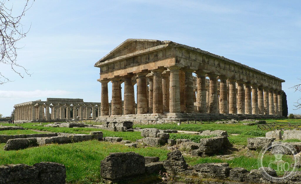
Paestum (UNESCO 1998, rif. 842) ospita i tre templi greci meglio conservati fuori dalla Grecia: fondati dalla colonia achea di Poseidonia c.600 BCE, i templi di Hera I (550 BCE), Hera II “Nettuno” (460 BCE) e Atena (500 BCE) sono rimasti sepolti sotto la vegetazione dalla tarda antichità al 1746 CE — e la loro conservazione eccezionale dipende da questa lunga invisibilità.
At a glance
Paestum Cilento Campania (the most precisely Paestum zone Capaccio Paestum Salerno Campania Italy 40.4219 N 15.0047 E UNESCO WHS 1998 reference 842 Cilento and Vallo di Diano National Park with the Archeological Sites of Paestum and Velia: the site (the overall UNESCO site: 181,048 ha (the entire Cilento National Park + Paestum + Velia + the mountain sites of Certosa di Padula and the sanctuary of Hera Argiva at the mouth of the Sele river)); the Paestum component (the archaeological site: the ancient Greek colony of Poseidonia (founded c.600 BCE by Achean Greek settlers from Sybaris (the Greek polis in modern Calabria: also extinct)); the city plan: the rectangular street grid (the “ippodamea” grid: named after the planner Hippodamus of Miletus who theorized the grid plan: the Paestum grid predates Hippodamus by 50–100 years (Hippodamus: c.498–408 BCE; the Paestum grid: c.550 BCE)); the temples (the 3 surviving Greek temples: (1) the Temple of Hera I (the “Basilica”: the erroneous name given by 18th-century CE excavators who thought it was a Roman basilica: actually a temple; c.550 BCE; 50 columns (9 front columns × 18 lateral + 1 median central column: the odd number of front columns is unique in the Greek world and indicates the temple was dedicated to a female deity (the even number of columns on the front is the standard for male deities)); (2) the Temple of Hera II (the “Temple of Neptune”: the name given by 18th-century CE excavators who misidentified the deity (it’s dedicated to Hera, not Neptune); c.460 BCE; the most intact Greek Doric temple: 36 columns (6 front × 14 lateral), all standing; the frieze blocks: present on 3 sides; the internal columns: the only Greek temple at Paestum where the internal 2-story colonnade (the inner naos columns) survives intact: 7 columns per side × 2 levels = 28 visible internal columns)); (3) the Temple of Athena (the “Temple of Ceres”: the name misattributed by 18th-century CE excavators; c.500 BCE; the intermediate size between the 2 Hera temples; the frieze and metopes: carved with the Gigantomachy (the battle of Gods vs. Giants): fragments in the museum)).
Key facts
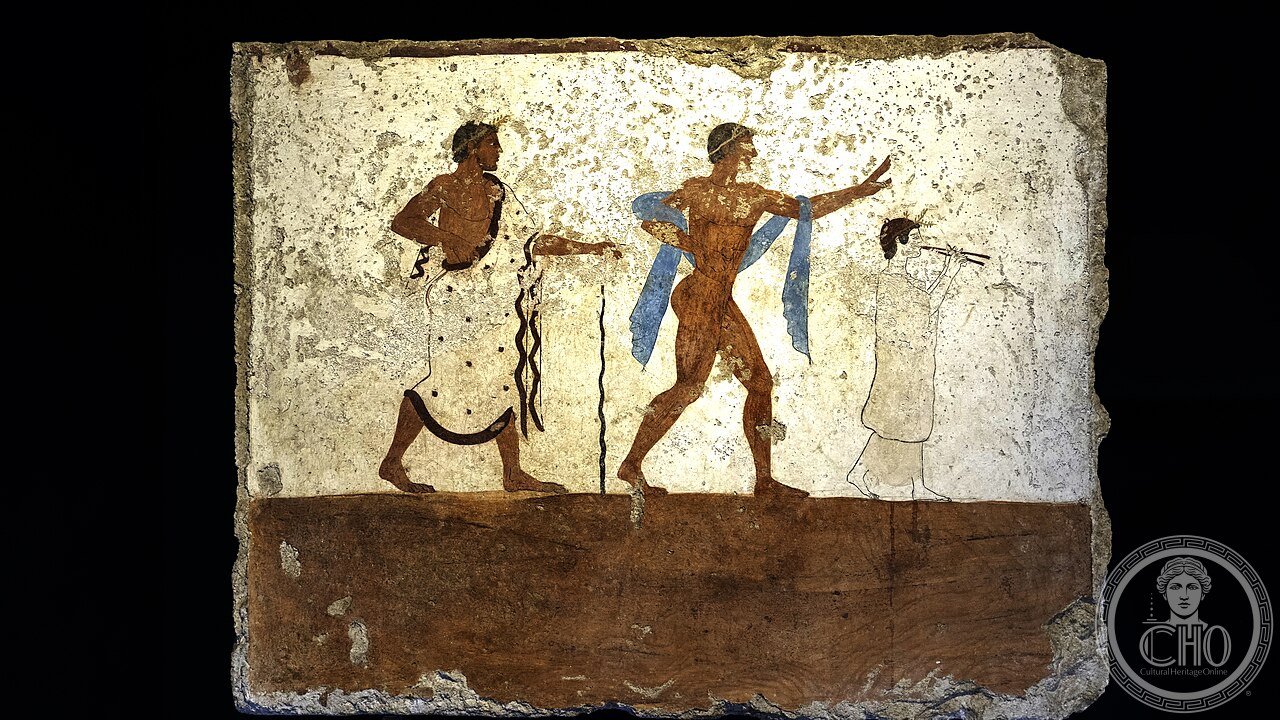
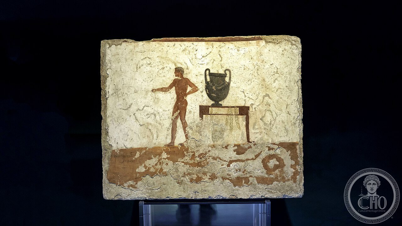
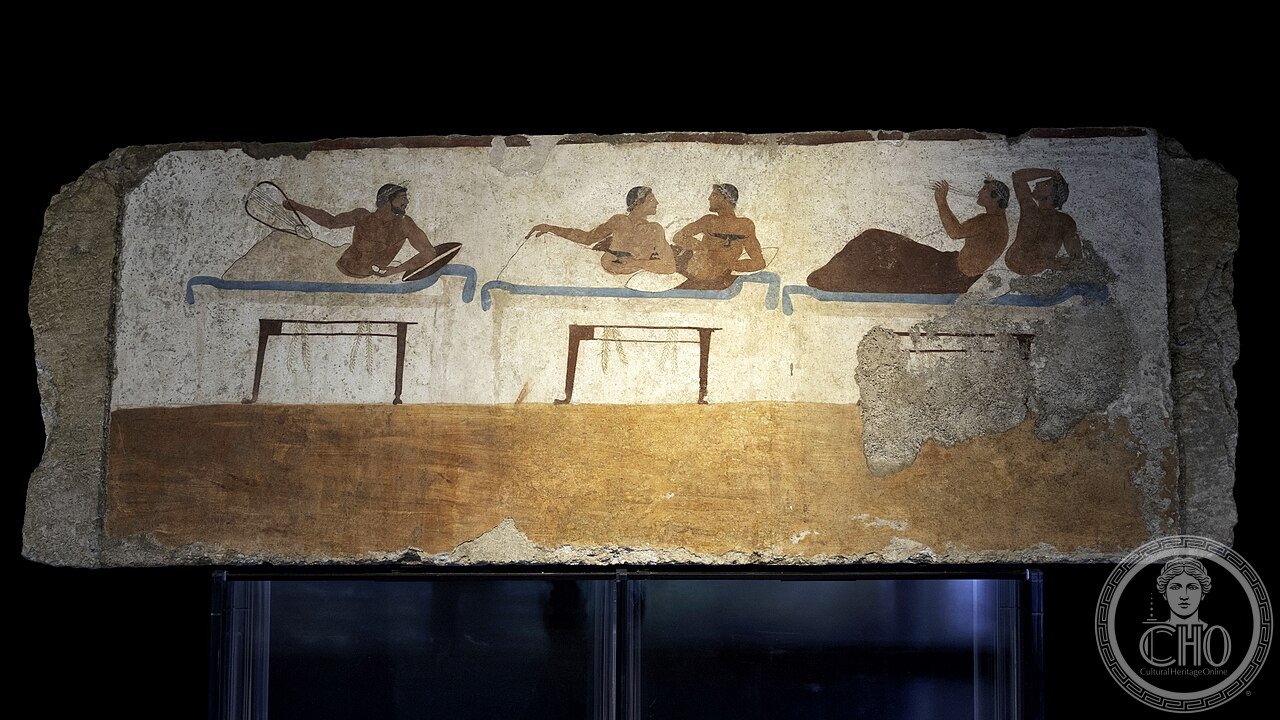
- La Tomba del Tuffatore di Paestum (480 BCE) e perché è la sola pittura funeraria greca del V sec. BCE mai ritrovata (e cosa significa veramente il “tuffatore”): the Tomb of the Diver (the “Tomba del Tuffatore” (480 BCE): found 1968 CE by Mario Napoli (Superintendent of Antiquities for Salerno) in the southern necropolis of Paestum (800 m south of the city walls): a stone tomb (the limestone slabs forming a box grave: 2.16 m × 1.0 m × 1.0 m); the paintings (the 5 painted slabs (the 4 side panels + the lid panel): painted in encaustic (wax-based paint) with fresco technique directly on the limestone: the only known example of Greek figurative painting from the 5th century BCE (all other examples from this period were on wooden panels: all lost)); the iconography (the lid (the famous “diver” panel): a young man diving from a tall platform into a body of water; the interpretation (the 3 main readings: (1) the “Symposium journey” interpretation (the mainstream view (2000s CE)): the diver represents the transition from life to death (the dive = the crossing from the world of the living to the Underworld (Hades); the 4 side panels show a symposium (drinking party): the symposium = life; the dive = death; (2) the Pythagorean interpretation: the symposium was a philosophical gathering (Paestum was in a region with strong Pythagorean influence; Pythagoras taught in Croton, 100 km to the south); the dive = the reincarnation of the soul (the Pythagorean metempsychosis); (3) the athletic interpretation: the oldest (1968 CE): the “diver” is an athlete performing a competitive dive: this reading is now rejected because the “platform” is too tall for athletic diving and resembles the mythical pillars of Heracles)); the display (the Museo Nazionale di Paestum: Room 3: the complete reconstructed tomb with all 5 panels visible from a raised platform; the museum closed for restoration 2022 CE–2024 CE; reopened 2025 CE)
- GPS (ingresso Parco Archeologico di Paestum, Via Magna Graecia): 40.4219° N, 15.0047° E
History
Da Poseidonia 600 BCE al UNESCO 1998 (the most precisely Paestum zone history: the foundation (the Greek colony: the Achaean polis of Sybaris (the city on the Ionian coast of Calabria) founded Poseidonia c.600 BCE as a trading colony on the Tyrrhenian coast of Lucania (modern Campania); the purpose: trade with the Etruscan cities of Campania (Capua, Nola, Saticula)); the Lucanian conquest (400 BCE: the Lucanians (the Oscan-speaking italic people of the Apennine interior) conquered Poseidonia and renamed it Paistom/Paistano → “Paestum”; the Lucanians continued using the Greek temples (evidence: the Greek votive offerings continue post-400 BCE in the archaeological record)); the Roman period (273 BCE: Paestum became a Roman colonia; the Latinization (the city was renamed “Paestum”; the Latin language replaced the Lucanian dialect by 200 BCE)); the abandonment (the “Paestum silence” (c.500 CE–1746 CE): the city was progressively abandoned from the late Roman period due to malaria (the Sele river silted and created swamps; the malaria eliminated the population by c.700 CE); the forest grew back: the 3 temples were visible only as grey masses in the “Foresta di Paestum” (the local name for the maquis covering the ancient city)); the rediscovery (1746 CE: the Bourbon road engineers (building the Royal Road from Naples to Reggio Calabria under Charles III de Bourbon) cut through the maquis and encountered the columns of the temples for the first time in modern history; the first scholarly publication: Gasparo Maria Paoli, “Paesti quod Posidoniam etiam dixere rudera” (Naples, 1784 CE))); the UNESCO inscription (1998 CE: reference 842).
What you see
3 Templi greci (Hera I 550 BCE, Hera II 460 BCE, Atena 500 BCE), Mura greche V sec. BCE, Foro romano, Tomba del Tuffatore (Museo) (the most precisely Paestum zone visit (3–4 hours): the archaeological site (€13 (combinato sito + museo); 9:00–19:30 (ultimo ingresso 18:30); the visit sequence: enter via the main entrance (Via Magna Graecia 887): the Temple of Hera II (“Nettuno”; the best-preserved of the 3 temples; the 36 Doric columns: walk completely around the peristyle at close range; the travertine (the material: travertine from the local Sele river deposits; the weathering: the travertine has developed a golden-orange patina from 2,500 years of sun and rain; the color is one of the most photographed aspects of the site)) → the Temple of Hera I (“Basilica”: 50 columns; the 9 front columns; the polygonal base (the 3-step krepidoma): 5 m high): the detail to look for: the entasis (the deliberate swelling of the columns at the 1/3 point: 2.5 cm outward from the straight line: designed to correct the visual illusion of concavity when viewed from below)) → the Temple of Athena (“Ceres”; the intermediate size; the best example of the Doric-to-Ionic transition: the pronaos columns are Ionic (with bases and capitals), while the peristyle columns are Doric (without bases))); the Museo Nazionale di Paestum (the museum: adjacent to the site; €6 (included in the combined ticket); Room 3: the Tomb of the Diver (480 BCE): the 5 painted panels reassembled; the metopes from the Temple of Hera at the Sele river Sanctuary (the sculpted friezes from the Temple of Hera Argiva (6th–5th century BCE): 33 metopes depicting the deeds of Heracles and myths from the Sybaris cycle: the finest Greek sculpted limestone metopes outside Agrigento).
Practical information
- Come raggiungere Paestum da Napoli e Salerno senza auto, e dove mangiare mozzarella di bufala DOP direttamente in fattoria vicino agli scavi: il trasporto (Napoli Centrale → Paestum: Trenitalia (1h30–2h; €5.50; cambio a Salerno; il treno locale per Agropoli-Ascea; fermata: “Capaccio-Roccadaspide” (attenzione: non “Paestum”): la fermata di Capaccio-Roccadaspide è a 900 m dagli scavi (il percorso a piedi: Via Magna Graecia verso sud: 12 minuti a piedi in piano)); Salerno → Paestum: Trenitalia (45 min; €2.80; cambio a Battipaglia non necessario: il regionale diretto da Salerno arriva a Capaccio-Roccadaspide)); la mozzarella di bufala (il Caseificio Granato (Via Magna Graecia 900; 200 m dagli scavi): aperto 8:00–14:00: si può comprare la mozzarella appena fatta (la treccia: il formato tradizionale per la mozzarella di bufala aversana; la “mozzarella di bufala DOP Campania” (Regolamento CE 2527/2000: il latte delle bufale di 4 province: Salerno, Caserta, Napoli, Benevento: confermato da Coldiretti Campania)): acquistare 500g (4 mozzarelle) + ricotta di bufala (disponibile solo la mattina); mangiarle al tavolo degli scavi con il vino Fiano di Avellino DOCG bianco)
Getting there
Trenitalia da Napoli (1h30, €5.50, fermata Capaccio-Roccadaspide). Da Salerno (45 min, €2.80). GPS: 40.4219/15.0047. €13 (combinato sito+museo). 9:00–19:30.
Nearby
- Certosa di San Lorenzo di Padula (UNESCO 1998 rif. 842 — la più grande certosa d’Italia; 1306 CE; chiostro 152 × 120 m) — 65 km (auto 1h; la Certosa di Padula (14.000 m²; il chiostro grande di 152 × 120 m: il quinto più grande del mondo; la cucina (il refettorio con le 2 cucine gemelle con le fontane interne: una delle più elaborate cucine monastiche in Italia)))
- Velia (Elea 540 BCE — Parmenide + Zenone; Porta Rosa 300 BCE) — 40 km (auto 35 min; Elea (540 BCE): la colonia focea (da Focea in Ionia, oggi Turchia): la polis fondata da Parmenide (515–450 BCE: “l’essere è; il non-essere non è” (Poema della Natura): la Scuola Eleatica di Filosofia): il Parco Archeologico di Velia (aperto 9:00–19:30; €6); la Porta Rosa (300 BCE: il primo arco a tutto sesto in calcare mai trovato in Italia))
Gallery
Sources
- Wikipedia, Paestum; Tomb of the Diver; Cilento and Vallo di Diano National Park, accessed June 2026
- UNESCO, Cilento, Vallo di Diano and Alburni National Park with the Archaeological Sites of Paestum and Velia, and the Certosa di Padula, WHS reference 842, inscribed 1998
- Napoli, Mario. La Tomba del Tuffatore. Bari: De Donato, 1970 (the excavation report)
Find it on the map
See this place and what’s around it →📷 Diventa un fotografo di Cultural Heritage Online
Condividi le tue foto dei luoghi: restano pubblicate con la tua firma come autore. Più vengono viste, più ti fai conoscere — e presto un concorso premierà le foto più apprezzate.
Accedi o registrati gratis per aggiungere una foto