Mont Saint-Michel — Normandy
A tidal island off the Normandy coast, crowned by a Gothic abbey that monks began building in the 11th century — Mont Saint-Michel has the highest tidal range in continental Europe and has been a pilgrimage destination for 1,300 years.
At a glance
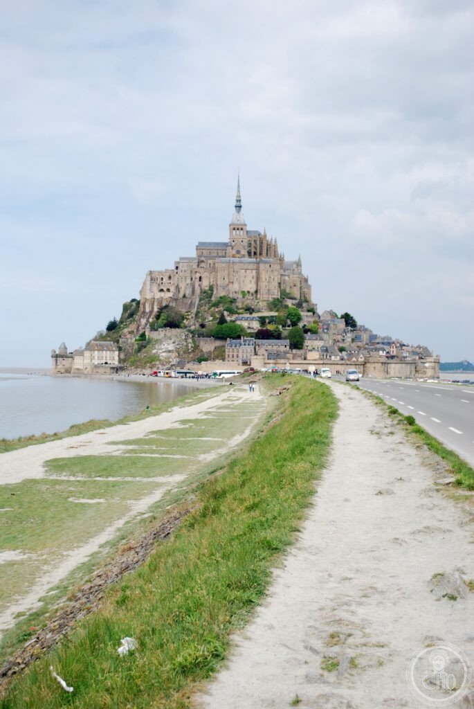
Mont Saint-Michel rises 92 metres above a tidal bay at the border of Normandy and Brittany, its Gothic abbey church, cloister, and monastic buildings climbing the granite outcrop in a vertical succession from the medieval village at the base to the spire at the summit. According to tradition, Bishop Aubert of Avranches received a vision of the Archangel Michael in 708 AD and founded an oratory on the island; a Benedictine monastery was established in 966, and the abbey complex as it exists today was built primarily between the 11th and 16th centuries. During the Hundred Years’ War the island served as a fortress that repelled English siege; during the French Revolution the abbey was converted to a prison; since the 19th century it has been a major cultural heritage site. With approximately 3 million visitors annually, Mont Saint-Michel is the second most visited monument in France after the Eiffel Tower. It was inscribed as a UNESCO World Heritage Site in 1979.
Key facts
- Founded: Oratory 708 AD (tradition); Benedictine abbey established 966; current Romanesque nave begun 1017
- Style: Romanesque nave (11th–12th century); Gothic choir and La Merveille complex (13th century); Gothic spire restored 19th century
- Tidal range: up to 14 metres at spring tides — the highest in continental Europe; the island becomes fully surrounded at high tide
- Height: 92 metres from sea level to the tip of the spire; the gilded statue of Saint Michael at the summit (1897) is a landmark from 50 km away
- Heritage: UNESCO World Heritage Site and its Bay, inscribed 1979, extended 2007
- Residence: a small community of Benedictine monks has been resident since 2001, restoring the monastic life interrupted by the Revolution
- GPS: 48.6361° N, 1.5115° W
History
The founding of the sanctuary on Mont Tombe (the original name of the island) is attributed by tradition to 708, when Bishop Aubert of Avranches built a small chapel following a vision; a strand of his skull, allegedly pierced by the Archangel’s finger to compel his obedience, is preserved in the treasury of Saint-Gervais church in Avranches. The island became a pilgrimage site for the cult of Saint Michael, one of the most important archangels in the Western Christian tradition. Duke Richard I of Normandy established the Benedictine abbey in 966, and the monastery grew in prestige, wealth, and architectural ambition over the following centuries.
The Romanesque nave of the abbey church was built between 1017 and 1144, its granite pillars and round arches standing on a complex of underground crypts and chapels that served both as structural supports and as additional spaces of worship. The 13th-century addition known as La Merveille (The Marvel) — three tiers of halls including the refectory, the knights’ hall, the cloister, and the guests’ hall — was completed between 1211 and 1228 and represents one of the finest examples of early French Gothic secular architecture. During the Hundred Years’ War (1337–1453), the island was a royalist fortress; English forces besieged it for thirty years without success. In 1423 the English burned the village at the foot of the mount but could not take the fortified abbey.
The French Revolution suppressed the monastery in 1790 and converted the buildings to a prison, which operated until 1863. The subsequent restoration, driven by the growing heritage consciousness of the 19th century, returned the buildings to ecclesiastical use and added the current Neo-Gothic spire (1897). The tidal causeway constructed in 1877 solved the access problem for tourists but eventually altered the sedimentation patterns in the bay, partially filling the tidal flats around the island. A major hydraulic project completed in 2015 — replacing the causeway with a bridge on stilts — restored the tidal dynamics around the island for the first time in over a century.
What you see
The approach, whether on foot across the tidal flats or on the shuttle from the car park, reveals the island progressively: the lower village of medieval houses and pilgrim shops, then the ring of fortified walls with their towers, then the abbey buildings climbing the rock in successive tiers, finally the Gothic church and spire. The profile changes with the light and the tide; at sunset in the autumn, when the bay reflects the pink sky and the island stands against the dark of the sky to the west, the view is among the most arresting in Europe.
Inside the abbey, the ascent through the crypts and halls of La Merveille to the cloister and church follows a sequence of spaces that Abbot Jourdain intended as a movement from earth toward heaven. The cloister — a double row of slender columns in pink granite, their arches filled with foliate carving — is the summit of the complex’s architectural quality. The abbey church above presents a Romanesque nave, a Gothic choir, and a crossing tower; the interior is austere in the 19th-century manner, most of the medieval furnishings having been removed during the Revolution.
Practical information
- Location: off the Normandy coast, 2 km from the mainland near Pontorson; access by shuttle bus from car park (2 km) or on foot across the tidal flats with a guide
- Abbey hours: daily 9:30 am–6 pm (July–August 9 am–7 pm); closed 1 January, 1 May, 25 December
- Admission: abbey EUR 13 adults; surroundings and village free
- Tidal crossing: guided walks across the bay at low tide available; book with licensed operators. NEVER attempt without a guide — the tide returns at 30 km/h
- Time needed: half day minimum; overnight recommended (the island is transformed after the crowds leave)
Getting there
Mont Saint-Michel is accessible by road from Pontorson (9 km, shuttle bus from the mainland car park) or from Rennes (1.5 hours by car). TGV from Paris Montparnasse to Rennes (1.5 hours), then bus to Mont Saint-Michel (1 hour). Paris to Mont Saint-Michel by car is approximately 3.5 hours. GPS: 48.6361, -1.5115.
Nearby
- Avranches — the episcopal town whose bishop founded the sanctuary; the manuscript library contains the Bible of Abbot Robert de Torigny (12th century); 30 km south
- D-Day beaches (Normandy) — the Allied landing beaches of June 1944 (Utah, Omaha, Gold, Juno, Sword) are 100–150 km north-east along the Normandy coast
- Bayeux — home of the 11th-century Bayeux Tapestry depicting the Norman Conquest; 120 km north-east
- Saint-Malo — the walled corsair town on the Brittany coast; 55 km west
Sources
- Wikipedia, Mont Saint-Michel, accessed June 2026
- Official site: abbaye-mont-saint-michel.fr
- UNESCO, Mont Saint-Michel and its Bay, WHS reference 80bis, inscribed 1979/2007
- Lucien Musset, Normandie Romane, Zodiaque, 1967 — architectural analysis of the Romanesque nave
Find it on the map
See this place and what’s around it →📷 Diventa un fotografo di Cultural Heritage Online
Condividi le tue foto dei luoghi: restano pubblicate con la tua firma come autore. Più vengono viste, più ti fai conoscere — e presto un concorso premierà le foto più apprezzate.
Accedi o registrati gratis per aggiungere una foto