Los Glaciares National Park
One of the most dynamic ice landscapes on Earth and the home of the Perito Moreno Glacier — one of the very few large glaciers in the world that is not currently retreating — Los Glaciares National Park in Argentine Patagonia protects 47 glaciers fed by the Southern Patagonian Ice Field, the world’s third largest freshwater reserve, including the periodically-advancing Perito Moreno Glacier and the iconic rock spires of Cerro Torre and Cerro Fitzroy.
At a glance
Los Glaciares National Park (448,000 hectares; established 1937; UNESCO WHS 1981) is divided into two primary visitor sectors: the southern sector, centred on El Calafate (the gateway town, 80 km east of the park boundary; served by El Calafate International Airport with direct flights from Buenos Aires), contains the Perito Moreno Glacier and the three arms of Lake Argentino (the Brazo Rico, Brazo Sur, and Brazo Norte); the northern sector, centred on El Chaltén (the base for trekking, 220 km north of El Calafate; 3h by road; a purpose-built trekking village established in 1985 to assert Argentine sovereignty over the area), contains the climbing and trekking peaks of Cerro Fitzroy (3,359 m; also called Monte Fitz Roy; known in Mapuche as Chaltén, “smoking mountain”, for the lenticular cloud cap it generates; the defining peak of Patagonia’s silhouette) and Cerro Torre (3,102 m; a smooth granite pinnacle capped with permanent ice mushrooms; one of the most technically difficult mountains on Earth); between the two sectors runs the Southern Patagonian Ice Field (Campo de Hielo Patagónico Sur; approximately 13,000 km²; the world’s third largest freshwater reserve after Antarctica and Greenland; the source of all 47 glaciers in the park).
Key facts
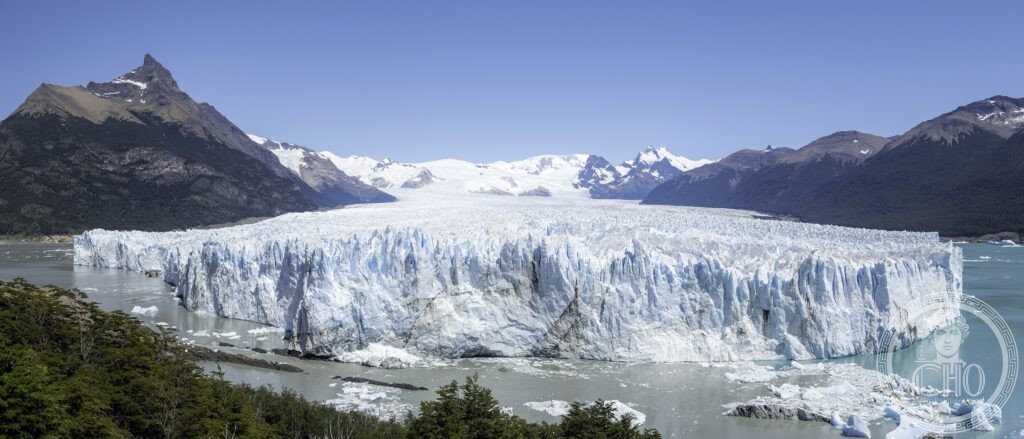
- The Perito Moreno Glacier: one of the world’s few non-retreating glaciers and the most accessible major glacier on Earth — the Perito Moreno Glacier (named after the Argentine explorer and conservationist Francisco Moreno, 1852–1919, who was instrumental in creating the national parks system and in the Chilean–Argentine border arbitration) is a temperate outlet glacier of the Southern Patagonian Ice Field that flows approximately 30 km from its accumulation zone to its calving front on Lake Argentino; it is one of the few large glaciers in the world that is neither retreating nor advancing on balance (it periodically advances by 2 metres per day during cycles lasting several years, until it reaches the southern shore of the Brazo Rico arm of Lake Argentino, where it dams the water completely, raising the water level in the Brazo Rico by up to 30 metres; the ice dam eventually ruptures in a spectacular event that can last 3–4 days, with enormous ice arches forming and collapsing into the torrent of water; rupture events occurred in 1988, 2004, 2006, 2008, 2012, and 2016, among others); the ice front (5 km wide; 60–70 metres above the lake surface; another 80–170 metres below; a wall of ice the colour of compressed air from centuries of atmospheric compression) calves constantly — pieces the size of apartment buildings break off the face and crash into the lake; the wooden boardwalk system on the rocky peninsula facing the ice front provides approximately 3 km of viewing platforms at various heights and distances from the ice (the closest platform is approximately 100 metres from the ice face; the calving sounds are thunderous; the spray from large calving events reaches the platform)
- Cerro Torre (3,102 m): the most controversial and most coveted mountain in the world — Cerro Torre is a smooth granite pinnacle approximately 400 metres high (the upper 400 metres of a 3,102-metre peak), capped with overhanging mushrooms of blue ice (compressed rime ice formed by ferocious Patagonian storms); the summit was first claimed by the Italian climber Cesare Maestri in 1959 (with his partner Toni Egger, who died in an avalanche on the descent and whose body was only found in 2015; Maestri’s account of the first ascent was doubted by the mountaineering community from the beginning because no photographs of the upper portion survived); in 1970, Maestri returned with a pneumatic drill and bolted a 350-metre line up the Southeast Buttress, leaving the compressor still attached on the mountain at his highpoint (which was not the summit); the first incontestable ascent of the summit was made by a Californian team in 1974; the removal of Maestri’s compressor by the climber Hayden Kennedy in 2012 sparked a worldwide debate about alpine ethics; the mountain remains one of the most technically demanding, psychologically intimidating, and meteorologically challenging climbs on Earth
- The Upsala Glacier: the largest glacier in South America accessible by boat — the Upsala Glacier (60 km long; the longest glacier in South America outside the Antarctic; named after the University of Uppsala, Sweden, which conducted an early expedition here in 1908) is accessible by boat from Puerto Bandera on Lake Argentino (included in the Upsala-Spegazzini glacier day excursion from El Calafate; approximately 8h; the boat navigates through vast fields of calved icebergs — some the size of multi-story buildings — to the ice front); the Upsala is retreating rapidly (approximately 5 metres per day, 1,500+ metres per year in recent decades) and the ice front has withdrawn significantly since the 1970s; the contrast between the retreating Upsala and the equilibrium Perito Moreno is one of the clearest visual demonstrations of differential glacier response to climate change accessible to general visitors
- Heritage: UNESCO World Heritage Site, Los Glaciares National Park, inscribed 1981
- GPS: -50.4925° S, -73.0561° W
History
The area was inhabited by the Aónikenk (Tehuelche) people for thousands of years; the first European expedition to the Fitzroy area was by Francisco Moreno in 1877; Moreno named the Perito Moreno Glacier and the Viedma Glacier; the national park was created in 1937; UNESCO WHS 1981; El Chaltén was founded in 1985; the first ascent of Fitzroy was in 1952 by the French team Lionel Terray and Guido Magnone; the Cerro Torre controversy (Maestri 1959 claimed summit; 1974 confirmed ascent; 2012 compressor removal) is the longest-running ethics debate in mountaineering history.
What you see
The Perito Moreno Glacier (the wooden boardwalk system; the 60–70 metre-high ice front; calving events every few minutes to every hour depending on temperature; the turquoise colour of compressed ice blocks that have just calved; the park infrastructure is excellent — paved road from El Calafate, large car park, café at the starting point of the boardwalk, no entrance to the glacier itself without a guide); the trekking peaks of El Chaltén (the Fitz Roy trek, 4–6h return from El Chaltén, gives close views of the granite towers reflected in Laguna Capri; Mirador del Fitz Roy is the classic photo stop; the Laguna de los Tres trail, 8–9h return, reaches the moraine directly below the Fitzroy east face, with views of both Fitzroy and Cerro Torre).
Practical information
- Access and fees: the Perito Moreno Glacier sector: park entrance approximately USD $35 (2026 tariff; payable in Argentine pesos at the equivalent rate); the glacier boardwalk system is free once inside the park; the recommended minimum visit is 3–4h; guided ice trekking on the glacier surface (via the Minitrekking or Big Ice program; crampons provided; approximately USD $60–120 per person) is the most memorable glacier experience and is booked separately through licensed operators in El Calafate; El Chaltén sector: trekking is free once in El Chaltén (no national park entry fee for hiking); the Fitz Roy and Cerro Torre treks are the most popular; registration at the ranger station required before trekking
- Getting there: El Calafate International Airport (FTE; direct daily flights from Buenos Aires EZE with Aerolíneas Argentinas, 3h; from Buenos Aires AEP Jorge Newbery, 3h; from Ushuaia, 50 min; from Bariloche, 1h 30 min); from El Calafate airport, the Perito Moreno Glacier is 80 km west (1h 30 min by road; regular tour buses from El Calafate depart 8am–9am daily; return in the afternoon; car rental also available); El Chaltén is 3h north of El Calafate by road (220 km; bus services from El Calafate depart daily)
- Best season: October–April (Southern Hemisphere spring/summer/autumn); the best months are November–March (long daylight hours; temperatures 5–15°C at the Perito Moreno Glacier; hiking conditions optimal in El Chaltén in December–February; the Patagonian winds are strongest December–February and calming in October–November and March–April); the glacier is accessible year-round but July–September is cold (−5°C to 5°C), dark (sunrise 10am in mid-winter), and significantly quieter
Getting there
El Calafate Airport (FTE) — 3h from Buenos Aires. Glacier 80 km from town (1h 30 min). El Chaltén trekking base 220 km north (3h). GPS: -50.4925, -73.0561.
Nearby
- Torres del Paine National Park (Chile) — 100 km west of the Perito Moreno Glacier (3h by road via the Cerro Castillo border crossing; good paved and gravel road; the crossing is straightforward); the most famous trekking destination in South America — Torres del Paine (240,000 hectares; a Chilean national park; not a UNESCO WHS but nominated and in many ways equivalent in quality) is centred on the Torres del Paine (the “Towers of Paine”; three granite towers of 2,850 m, 2,800 m, and 2,500 m height that rise from a glaciated base; the most iconic rock formation in Patagonia; visible from 50 km on clear days); the park offers the W Trek (5 days; the standard Patagonia trekking experience) and the O Circuit (9 days; the complete circumnavigation of the Paine massif); the park also contains the Cuernos del Paine (the “Horns of Paine”; another granite tower group), the Grey Glacier, several turquoise lakes, and a large Guanaco population
- Ushuaia and Tierra del Fuego — 1h 30 min by flight from El Calafate (FTE to USH; several daily flights); the southernmost city in the world and the gateway to Antarctica — Ushuaia (population approximately 77,000; Tierra del Fuego Province; on the Beagle Channel; 55° 04’ S latitude — the southernmost city in the world with a permanent population; the Fin del Mundo, “End of the World”) is the primary embarkation point for Antarctic expedition cruises (10–14 day voyages to the Antarctic Peninsula; Drake Passage crossing; the Weddell Sea icebergs; the penguin colonies of the South Shetland Islands; the Deception Island caldera); the Tierra del Fuego National Park (adjacent to Ushuaia; the southernmost national park in the world; the landscape of sub-Antarctic beech forest, peat bogs, and the Beagle Channel; the famous “Tren del Fin del Mundo” steam train runs through the park); the Beagle Channel (named after HMS Beagle, Charles Darwin’s survey vessel that mapped these waters in 1831–1836; the channel has colony islands of South American fur seals, Magellanic penguins, and Magellanic cormorants)
- Valdes Peninsula — 1,500 km north of El Calafate (2h by flight to Trelew, then 1h 30 min drive; UNESCO WHS 1999; one of the most important wildlife concentration sites in South America); the most important Southern Right Whale breeding site in the world — the Valdés Peninsula (3,625 km²; Chubut Province; a flat, semi-arid promontory extending into the South Atlantic; UNESCO WHS 1999) is most famous for the Southern Right Whale (Eubalaena australis; the Peninsula Valdés population is one of the most studied whale populations in the world; approximately 400–500 females use the protected bays of Golfo San José and Golfo Nuevo for calving and nursing in June–December; whale watching boats depart from Puerto Pirámides daily; viewing is at close range — 30–100 metres; the calving season October–November is the most spectacular); the peninsula also hosts the world’s largest Magellanic penguin colony (Punta Tombo, 160 km south; approximately 500,000 breeding pairs)
Sources
- Wikipedia, Los Glaciares National Park; Perito Moreno Glacier; Cerro Torre; Cerro Fitzroy, accessed June 2026
- UNESCO, Los Glaciares National Park, WHS reference 145, inscribed 1981
- Reinhold Messner, Torre: Thunder in the Mountain, Cordee, 1999
Find it on the map
See this place and what’s around it →📷 Diventa un fotografo di Cultural Heritage Online
Condividi le tue foto dei luoghi: restano pubblicate con la tua firma come autore. Più vengono viste, più ti fai conoscere — e presto un concorso premierà le foto più apprezzate.
Accedi o registrati gratis per aggiungere una foto