Koutammakou — The Land of the Batammariba
A living cultural landscape in northeastern Togo where the Batammariba people have built and ritually renewed their iconic Takienta tower-houses for over four centuries, guided by cosmological principles handed down entirely by word of mouth.
At a glance
Koutammakou stretches across the Kara Region of northern Togo and a small strip of neighbouring Benin, covering roughly 50,000 hectares of savannah, rocky plateaux and sacred groves. UNESCO inscribed it as a World Heritage Site in 2004 — one of only two such designations in Togo — recognising it as one of the most remarkable traditional settlement landscapes in West Africa. The site is not a ruin or a monument: it is a continuously inhabited landscape where ancient building traditions, agricultural practices and spiritual rituals are woven together in daily life.
Key facts
- UNESCO status: World Heritage Site since 2004; expanded 2023
- Location: Kara Region, north-eastern Togo (and a small portion of northern Benin)
- Area: approximately 50,000 hectares
- Inhabiting people: Batammariba (self-name meaning “those who are the real architects of earth”)
- Iconic structure: Takienta (sing.) / Tikenta (pl.) — cylindrical mudbrick tower-house with conical thatched roof
- Building tradition: oral transmission only; no written manuals or outside architects
- Ritual renewal: houses are ceremonially replastered and renewed by their owners, not merely repaired
- National symbol: the Takienta appears on the Togolese 1,000-franc banknote
History
The Batammariba are believed to have settled the Koutammakou region at least four centuries ago, migrating southward from the Sudan savannah belt. Their oral traditions link the founding of each compound to ancestral spirits and to the correct orientation of the house with respect to the sun — east for the living space, west for the ancestral altar. The name “Batammariba” itself encodes architectural identity: they are not simply inhabitants but the builders of the earth itself.
External contact was limited for centuries by the region’s relative remoteness. Colonial-era administrators and later ethnographers began documenting the Tikenta houses in the twentieth century, recognising them as a unique architectural achievement produced entirely without external influence. French architect and anthropologist Jean-Paul Bourdier undertook detailed studies of the spatial logic of these compounds in the 1980s, demonstrating how every structural element — granary height, doorway orientation, forecourt shape — encodes cosmological meaning.
UNESCO inscription in 2004 brought international visibility but also new pressures. The site was expanded in 2023 to include additional villages and sacred groves, reflecting the landscape-scale nature of the heritage rather than any single structure.
What you see
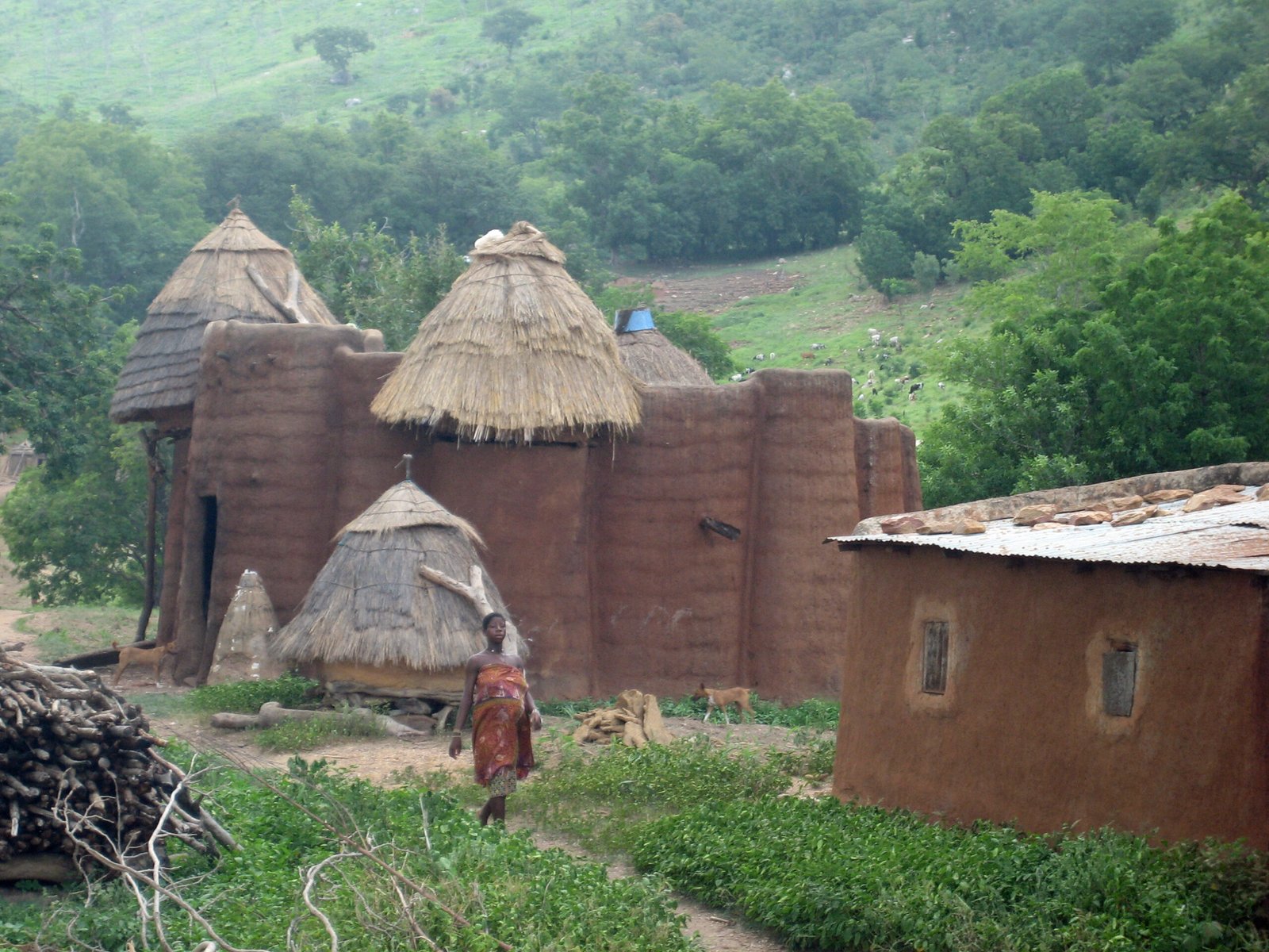
The defining feature of Koutammakou is the Takienta: a cylindrical tower, typically two storeys high, built from banco (sun-dried mudbrick) reinforced with timber. The ground floor is used for storage and livestock; the upper floor, reached by a notched log ladder, provides sleeping quarters. The roof is conical and thatched with millet stalks or guinea-grass. A small opening in the upper section of the tower connects to a flat-roofed terrace used for grain drying.
Each compound (a cluster of Tikenta belonging to one extended family) is arranged around an open forecourt orientated toward the east. The alignment reflects the Batammariba cosmology in which the rising sun represents life and ancestral blessing. Separate granary towers stand within the compound. Sacred trees and small earthen shrines mark the boundary between domestic and ritual space.
The mudbrick walls are replastered each year before the rainy season in a communal ceremony that reinforces social bonds as much as it repairs the building fabric. Unlike conventional maintenance, this replastering is understood as a renewal of the house’s spiritual vitality. The colour of the earth varies across the landscape from red laterite to pale ochre, giving each village a subtly different palette.
Why it matters
Koutammakou is a rare example of living intangible and tangible heritage inseparable from one another. The buildings cannot be understood without the rituals that renew them; the rituals cannot be performed without the buildings that give them form. This fusion challenges the conventional heritage framework that separates “monuments” from “living culture”.
The architectural achievement is remarkable: two-storey load-bearing mudbrick structures with integrated grain storage, ventilation and livestock quarters, designed and built by non-specialist community members guided by oral tradition alone. For scholars of vernacular architecture, Koutammakou provides one of the most complete surviving examples of how cosmological belief can determine structural form at every scale.
Practical information
- Access: The village of Nadoba, about 40 km northeast of Kara town, is the main entry point.
- Best time to visit: November to February (dry season).
- Guides: Local guides from the villages are strongly recommended and a customary entry fee to compound owners is expected.
- Photography: Always ask permission before photographing a compound or its inhabitants.
- Nearest town: Kara (approximately 100 km south); accommodation available there.
- Country entry: Togo requires a visa; e-visa available online. Yellow fever vaccination certificate required at entry.
Getting there
The nearest international airport is Lomé-Tokoin International Airport (LFW), approximately 600 km south of the site. Domestic flights link Lomé to Kara Airport (KAL). From Kara, shared taxis or chartered vehicles head north toward Kandé and the villages of the Koutammakou landscape. The drive from Kara takes roughly 1.5–2 hours depending on road conditions. Overland travellers from Benin can cross at the Kétao border post.
Nearby
- Kara — regional capital with markets, accommodation and the Kara Museum of local culture
- Fazao-Malfakassa National Park — protected savannah roughly 150 km south, with elephant and hippo populations
- Atakora (Benin) — the Somba people maintain closely related Tata Somba tower-houses across the border, part of the same living tradition
Sources
- UNESCO World Heritage Centre. “Koutammakou, the Land of the Batammariba.” whc.unesco.org. Decision 28COM 14B.7 (2004); expanded 2023.
- Bourdier, Jean-Paul, and Trinh T. Minh-ha. African Spaces: Designs for Living in Upper Volta. Holmes & Meier, 1985.
- Wikipedia contributors. “Koutammakou.” Wikipedia, The Free Encyclopedia. Accessed 2026-06-11.
Find it on the map
See this place and what’s around it →📷 Diventa un fotografo di Cultural Heritage Online
Condividi le tue foto dei luoghi: restano pubblicate con la tua firma come autore. Più vengono viste, più ti fai conoscere — e presto un concorso premierà le foto più apprezzate.
Accedi o registrati gratis per aggiungere una foto