Historic Sanctuary of Machu Picchu
The most visited and most photographed pre-Columbian site in the Americas and one of the most recognisable human constructions on Earth — Machu Picchu, the 15th-century Inca citadel perched at 2,430 metres in the cloud forest above the Urubamba River canyon in Peru, combines some of the most sophisticated dry-stone masonry in history with a dramatic landscape setting that no photograph, however familiar, fully prepares the visitor for on arrival.
At a glance
The Historic Sanctuary of Machu Picchu (UNESCO WHS 1983; a mixed (cultural + natural) UNESCO site — one of only 39 such combined sites in the world; approximately 32,592 ha; population of the closest town (Aguas Calientes / Machu Picchu Pueblo) approximately 5,000–8,000; located 75 km north-west of Cusco (as the crow flies; the travel time is 1h 30min by train from Cusco to Aguas Calientes)) was built approximately 1450 CE at the height of the Inca Empire (Tawantinsuyu; “the four quarters of the world”; the largest empire in pre-Columbian America; at its maximum extent (c.1527) the Inca Empire stretched from southern Colombia to central Chile — approximately 4,000 km from north to south — the longest continuous terrestrial empire in the history of the Americas) under the Inca emperor Pachacuti (the emperor who transformed the Inca state from a regional chieftaincy into a continental empire in approximately 35 years (1438–1471) — the most rapid imperial expansion in pre-Columbian history); the site appears to have been a royal estate (llaqta) and religious retreat for Pachacuti and his royal lineage (panaca) — it was likely inhabited by approximately 300–1,000 people during the Inca period (not a large city, as popularly imagined, but an elite residential and ceremonial complex); the site was abandoned during the Spanish conquest period (c.1572; the Spanish never discovered or destroyed Machu Picchu — the site was simply gradually forgotten by the local population (the Inca Trail leading to it fell out of regular use); the site was rediscovered for the outside world by the Yale historian Hiram Bingham III on 24 July 1911 (the date of his guided tour of the site by the local farmer Melchor Arteaga — Bingham was not the first outsider to know of the site, but his photographs and publications in National Geographic (1913) made Machu Picchu famous worldwide).
Key facts
- Inca masonry: the most sophisticated dry-stone architecture in the pre-Columbian Americas — the Inca construction technique (the Inca built without mortar; the stones were fitted together with such precision (the joints are so tight that a knife blade cannot be inserted between them in the finest examples) that the walls of Machu Picchu have survived 575 years of Andean seismic activity without significant structural failure; the technique (the stones were quarried on-site or near-site (the principal quarry is visible at the site, above the urban sector) using bronze and stone tools; the stones were shaped by grinding and pecking rather than cutting with sharp instruments; the slight inward tilt of the walls (battered walls; the walls lean slightly inward — typically 2–5% from vertical — which increases their seismic resistance by lowering the centre of gravity of the structure); the trapezoidal doors and niches (the characteristic Inca architectural form; the top of the door or niche is narrower than the bottom, creating a trapezoidal opening — the most visually distinctive element of Inca architecture and the most structurally efficient form for earthquake resistance); the Intihuatana (Quechua: “hitching post of the sun”; the carved stone pillar in the highest point of the urban sector; the function (a solar observatory used to track the solstices and equinoxes; the shadow of the pillar at solar noon on the equinox falls directly in the N–S axis; the shadow at summer solstice (December in the southern hemisphere) points directly toward Salcantay mountain (the most sacred Apus (mountain deity) of the Machu Picchu region)); only one Intihuatana in the Inca Empire was not deliberately destroyed by the Spanish (the Spanish systematically destroyed Intihuatanas wherever they found them as instruments of “idolatry”; Machu Picchu’s Intihuatana survived only because the Spanish never found the site))
- The Inca Trail: the most famous trek in South America — the Inca Trail (Camino Inca; the most famous multi-day trek in South America and one of the most famous in the world; a 43-km section of the Inca road network (Qhapaq Ñan; UNESCO WHS 2014; the 30,000-km Inca road system — the longest road network in pre-Columbian America) connecting the Ollantaytambo start point (2,792 m) with the Sun Gate (Inti Punku; 2,730 m) above Machu Picchu; the highest point: the Dead Woman’s Pass (Warmiwañusqa; 4,215 m; the most challenging section; approximately 4h of ascent on the second day); the duration (4 days / 3 nights for the classic route; the trail typically enters the sanctuary via the Sun Gate (the most dramatic entrance to Machu Picchu — the first sight of the citadel from above at dawn) on the morning of day 4); the restrictions (a maximum of 500 permits per day including guides and porters; effectively approximately 200 trekkers per day; permits must be booked 3–6 months in advance for the peak season (June–August); the trail is closed in February for maintenance; the porter regulations (a strictly enforced maximum weight per porter of 20 kg (25 kg including their own personal gear) — the most progressive porter protection regulation in the South American trekking industry)); the alternative routes (the Salkantay Trek (5 days; crosses the 4,630-m Salkantay Pass under the Salkantay snowfield; one of the finest mountain landscapes in the Andes; not as famous as the Inca Trail but generally considered more dramatic); the Lares Trek (3–4 days; through Quechua-speaking mountain communities; the most culturally immersive alternative route to Machu Picchu))
- The controversy: carrying capacity and the repatriation dispute — the management crisis (Machu Picchu received approximately 1.5 million visitors in 2019 (before the pandemic); the site’s carrying capacity has been estimated at 2,500 visitors per day (the maximum sustainable daily number) but the site routinely received 5,000–6,000 visitors per day in peak periods before visitor caps were introduced; the current regime (timed entry tickets with three time slots per day; a maximum of 4,044 visitors per day (the post-pandemic cap set in 2021)); the Bingham repatriation dispute (Hiram Bingham III removed approximately 47,000 artefacts from Machu Picchu on behalf of Yale University between 1911 and 1915; the artefacts (primarily ceramics, human remains, and bronzeware) were placed on “loan” to Yale; Peru has sought their return since 1918; after 93 years of negotiations, Yale and Peru reached an agreement in 2011 to return all the artefacts to Peru; the last shipment was returned in 2012 and the collection is now housed in the Museo Machu Picchu in the Casa Concha in Cusco))
- Heritage: UNESCO World Heritage Site (Cultural + Natural), Historic Sanctuary of Machu Picchu, inscribed 1983; one of the New Seven Wonders of the World, 2007
- GPS: 13.1631° S, 72.5450° W
History
The Inca Empire (Tawantinsuyu; founded approximately 1400 CE by Manco Cápac (the legendary founder) or Pachacuti (the historical founder of the imperial state); the empire at its maximum (c.1527) stretched from southern Colombia to northern Chile and Argentina (approximately 4,000 km north-south; 900,000 km² of territory); the population (approximately 10–12 million at maximum extent; the Inca system of governance (mit’a — the labour tax system; every household owed labour to the Inca state for a set number of days per year; the labour was used for state construction projects, military service, and agricultural production on state lands; the most efficient pre-industrial state labour-mobilisation system in the Americas)); Pachacuti and the construction of Machu Picchu (c.1438–1471; Pachacuti was the 9th Sapa Inca; in approximately 35 years he expanded the Inca state from a regional chieftaincy around Cusco into an empire stretching the length of South America; Machu Picchu was built early in his reign (approximately 1450 CE) as his private royal estate; the abandonment (c.1572; after the Spanish conquest of the Inca Empire (1533) and the execution of the last Inca emperor Túpac Amaru I; Machu Picchu was gradually abandoned; the last inhabitants left the site approximately 40 years after the Spanish conquest; the site was not destroyed by the Spanish because they never found it); Hiram Bingham III (24 July 1911; the Yale professor rediscovered the site for the outside world; the photographs and publications created the modern Machu Picchu; one of the New Seven Wonders of the World (2007)); UNESCO WHS 1983.
What you see
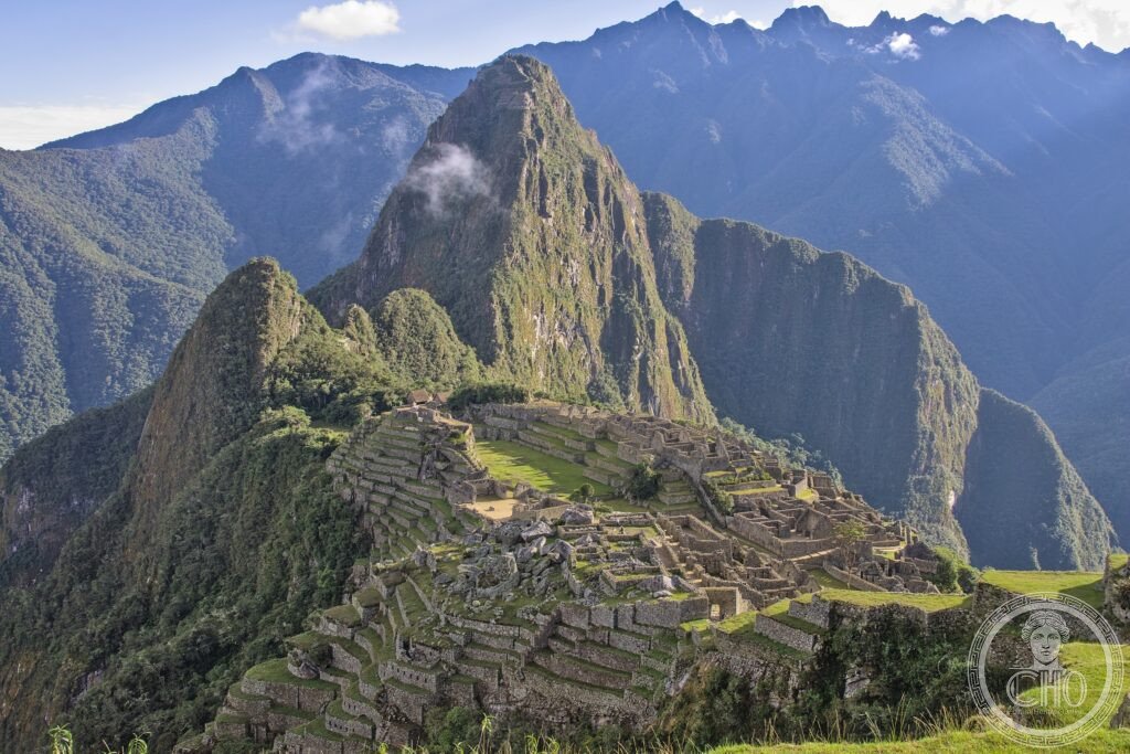
The site is divided into an agricultural sector (the terraces; the most extensive and best-preserved in the Inca world; the terraces served both agricultural production and slope stabilisation; the engineering sophistication (the 16 fountains (each connected to the next by stone channels; the finest water management system in any Inca site); the drainage system (invisible but extraordinary: the site sits on a ridge with heavy rainfall; the drainage channels prevent erosion and structural damage; the system is still functional after 575 years))) and an urban sector (the most architecturally important section; the Temple of the Sun (the only circular structure in Machu Picchu; the finest masonry in the site; the trapezoidal window (precisely aligned so that the first rays of the winter solstice sunrise pass through it and illuminate a specific stone on the floor below); the Sacred Plaza (the highest ceremonial space; the Principal Temple (three walls, missing the fourth; the finest wall masonry in the site — the joints between the stones are absolutely invisible); the Temple of the Three Windows (three large trapezoidal windows overlooking the urban sector; the windows frame a view that has appeared on every guidebook cover); the Intihuatana (the solar observatory pillar; described in Key Facts).
Practical information
- Getting there: the only access points are Cusco (the nearest city; 75 km south-east as the crow flies; 3h by train) and Aguas Calientes / Machu Picchu Pueblo (the town at the base of Machu Picchu; no road access to Aguas Calientes — only by train); the train from Cusco (Belmond Hiram Bingham (the most luxurious option; observation carriage; white-glove service; approximately USD 500 round trip; the most indulgent single train journey in South America) or PeruRail Vistadome / Expedition (USD 80–140 round trip; the practical option)); the route from Cusco (the train leaves from Poroy station (15 min from central Cusco by taxi) or from Ollantaytambo station (2h by car from Cusco through the Sacred Valley; the better option for seeing the Sacred Valley sites on the way)); the bus from Aguas Calientes (the 30-min zigzag road from Aguas Calientes to the site entrance; the line for the bus can be long in peak season; the walk up (approximately 1h 30min; very steep; the most physically demanding option but free); the permit (timed entry tickets must be purchased in advance (machu-picchu.gob.pe); slots sell out weeks in advance in July–August; three time slots: 6:00–12:00; 7:00–13:00; 12:00–17:30)
- Cusco (the essential complement): the Inca capital and the colonial gem of the Andes — Cusco (Qosqo; Quechua: “navel of the world”; the capital of the Inca Empire and the cultural capital of Peru; altitude approximately 3,400 m (the most challenging altitude adjustment for visitors coming from sea level; spending 1–2 days in Cusco before going to Machu Picchu allows acclimatisation — ascending to Machu Picchu from sea level without acclimatisation causes altitude sickness in a significant proportion of visitors)); the Plaza de Armas (the most beautiful main square in South America; the Cathedral (1654; built on the foundations of the palace of the Inca Viracocha; the most important church in colonial Peru; the Cusco School painting collection (the most important collection of Cusco School baroque paintings in any single building in Peru)); the Qorikancha (the Temple of the Sun; the most sacred building in the Inca Empire; the walls were originally covered in gold plates; the Spanish built the church of Santo Domingo directly on top of the foundations and walls of the Qorikancha — the most dramatic illustration of colonial overwriting of indigenous sacred sites in the Americas; the earthquake of 1950 (damaged Santo Domingo; exposed and restored the Inca walls underneath))
- The Sacred Valley: the Inca landscape between Cusco and Machu Picchu — the Urubamba Sacred Valley (the valley of the Urubamba River between Cusco and Ollantaytambo; the most important agricultural and settlement zone of the Inca Empire; the Inca chose the Sacred Valley for its unique microclimate (the valley floor at approximately 2,800 m is warm enough to grow maize — the prestige crop of the Inca elite — while the surrounding mountains at 4,000+ m are covered in potato and quinoa fields); the sites (Pisac (the market town with the finest Inca hillside fortress in the valley; the Sunday market is the most colourful indigenous market in the region); Ollantaytambo (the best-preserved Inca town in the valley; the only Inca town where people still live in original Inca houses (the kancha — the Inca urban module; rectangular enclosures of houses around a central courtyard)); Moray (the mysterious circular Inca agricultural laboratory; a series of concentric circular terraces descending 30 m into the earth; probably used to simulate different microclimates for agricultural experimentation; the most enigmatic Inca structure in the valley)))
Getting there
Train from Cusco (Poroy or Ollantaytambo) to Aguas Calientes (1h30–3h), then 30min bus up to the site. Timed entry tickets must be booked well in advance. GPS: -13.1631, -72.5450.
Nearby
- Chan Chan Archaeological Zone (UNESCO WHS 1986) — 900 km north of Cusco (near Trujillo, northern Peru; fly from Cusco); the largest pre-Columbian city in South America and the capital of the Chimú Kingdom — Chan Chan (the capital of the Chimú Kingdom (c.900–1470 CE; the largest pre-Inca state in the Andes); the adobe city (the largest pre-Columbian earthen architecture complex in the Americas; approximately 20 km²; 10 royal compounds (ciudadelas)); the construction material (sun-dried adobe bricks; the most vulnerable building material in the world (rain destroys adobe brick directly); Chan Chan is in the Atacama coastal desert where rainfall is effectively zero, which allowed the adobe construction to survive; climate change (increased El Niño rainfall events are damaging the site; UNESCO placed Chan Chan on the Danger List in 1986 — the site has been on the Danger List since the very year of its inscription))
- Nazca Lines (UNESCO WHS 1994) — 450 km south-east of Lima (flight or bus from Lima; the most convenient approach); the most mysterious pre-Columbian earthworks in the Americas — the Nazca Lines (geoglyphs; large figures (a hummingbird, a spider, a monkey, a condor, a human figure, triangles, spirals, and straight lines extending for kilometres) scraped into the pampas desert surface by removing the dark reddish-brown surface stones to expose the lighter yellow ground beneath; created by the Nazca culture (c.100 BCE–800 CE); the function (the most debated question in South American archaeology; the mainstream interpretation: a ceremonial landscape related to water rituals and ancestor worship; the most popular alternative (Erich von Däniken’s “alien landing strip” hypothesis (1968) — rejected by all archaeologists; the most famous pseudo-archaeological claim in modern history))); the viewing (the lines are visible only from the air; the 30-min overflights from Ica or Nazca airports; the most turbulent air due to desert thermals — motion sickness medication is strongly recommended))
- Lake Titicaca — 400 km south-east of Cusco (by train or bus; 7–9h; the Andean Explorer train (PeruRail; Cusco–Puno; the most scenic train journey in Peru)); the highest navigable lake in the world and the mythological birthplace of the Inca civilisation — Lake Titicaca (altitude 3,812 m; 8,372 km² (the largest lake in South America by surface area and volume); the Uros Floating Islands (the floating reed islands (totora reed) constructed and inhabited by the Uros people; the most unusual inhabited landscape in the Americas; the islands are built from layers of cut totora reed (the surface layer is replaced every few months as it decomposes; the islands themselves are anchored to the lakebed by ropes tied to poles); the island communities (approximately 80 islands; approximately 2,000 inhabitants; the tourist traffic (the floating islands are one of the most visited sites in Peru; the commercialisation of the visit has been criticised by anthropologists as replacing traditional culture with a tourist performance))
Sources
- Wikipedia, Machu Picchu; Inca Empire; Pachacuti; Inca Trail, accessed June 2026
- UNESCO, Historic Sanctuary of Machu Picchu, WHS reference 274, inscribed 1983
- John Rowe, “Absolute Chronology in the Andean Area”, American Antiquity 10(3), 1945 (the foundational chronological study of Inca history)
Find it on the map
See this place and what’s around it →📷 Diventa un fotografo di Cultural Heritage Online
Condividi le tue foto dei luoghi: restano pubblicate con la tua firma come autore. Più vengono viste, più ti fai conoscere — e presto un concorso premierà le foto più apprezzate.
Accedi o registrati gratis per aggiungere una foto