Great Wall of China — Jinshanling
Not a single wall but a system of walls, towers, and fortifications built across 2,300 years by successive Chinese dynasties — the Ming-dynasty sections at Jinshanling preserve the most intact run of the wall, watchtowers at every ridge summit, masonry tight as a cathedral vault.
At a glance
The Great Wall of China (Wanli Changcheng, “Ten-Thousand-Li Long Wall”) is a series of fortification systems built by successive Chinese states and dynasties between the 7th century BC and the 17th century AD to protect the Chinese heartland against nomadic incursions from the north. The total length of all sections, including branches, has been measured by Chinese surveys at approximately 21,196 kilometres (13,171 miles). The most visited sections — Mutianyu, Juyongguan, and Badaling — are near Beijing; the most photographed sections are Jinshanling (Hebei Province, 120 km north-east of Beijing) and Simatai (adjacent to Jinshanling). The Ming dynasty (1368–1644) built the majority of what survives today, reconstructing and expanding earlier walls in brick and stone. The Great Wall was inscribed as a UNESCO World Heritage Site in 1987.
Key facts
- Total length: approximately 21,196 km (all walls, all dynasties); Ming-dynasty wall alone approximately 8,850 km
- Construction periods: earliest walls from 7th century BC; Qin dynasty linked existing walls c. 221–210 BC; Han dynasty extended westward; Ming dynasty (1368–1644) rebuilt in brick and stone
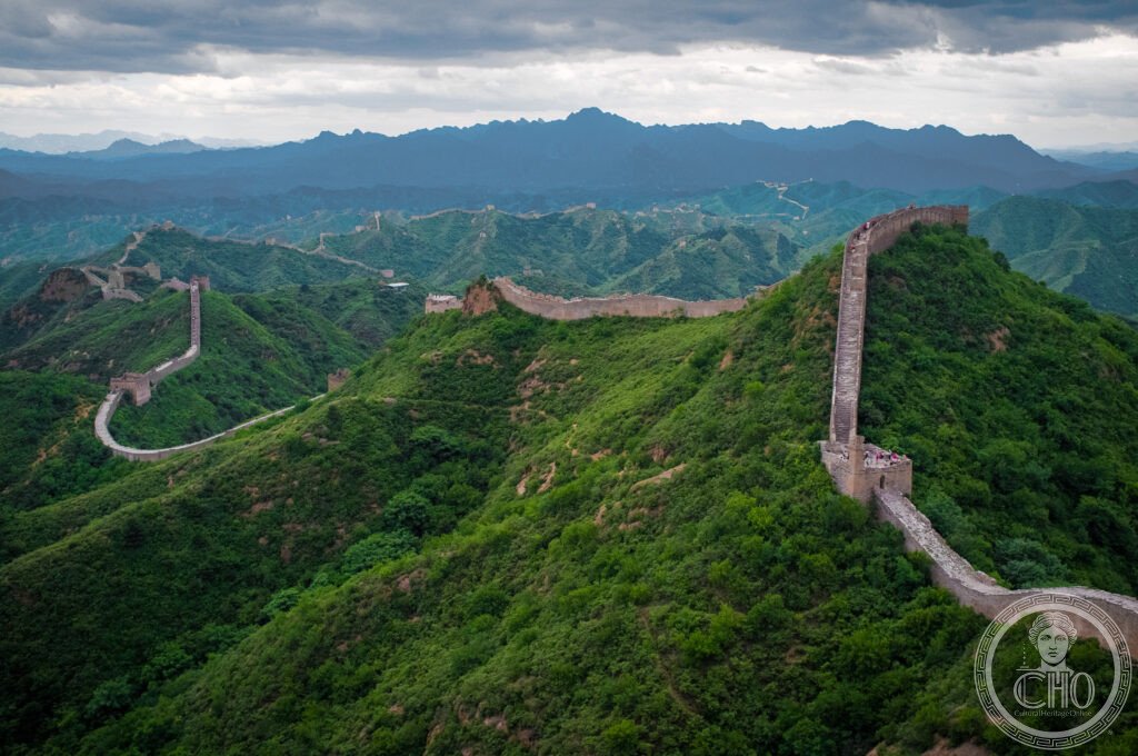
- Jinshanling section: 10.5 km long; 67 watchtowers; built 1368–1644; one of the best-preserved sections; 3–4 hours to walk end to end
- Construction materials: varies by section and period; Qin dynasty used tamped earth; Ming-dynasty sections use fired brick over stone foundations with lime mortar; the wall is 6–9 metres high, 4–5 metres wide at the top
- Not visible from space: the claim that the Wall is visible from space with the naked eye is a myth; it has been confirmed false by every astronaut who has attempted to see it
- Heritage: UNESCO World Heritage Site, inscribed 1987; one of the New Seven Wonders of the World (2007)
- GPS (Jinshanling): 40.6774° N, 117.2376° E
History
The idea of a northern defensive wall was not Qin Shi Huang’s invention, as is sometimes claimed. Several of the Warring States (403–221 BC) — particularly the states of Zhao, Yan, and Wei — had built walls along their northern borders against nomadic incursion during the 4th and 3rd centuries BC. When Qin Shi Huang unified China in 221 BC, he ordered his general Meng Tian to connect these existing walls into a continuous barrier along the northern frontier, using forced labour on a massive scale. Historical sources suggest that up to 300,000 soldiers and vast numbers of conscripted civilians worked on the project; casualties were so high that the wall was called “the longest cemetery in the world.”
The Han dynasty (206 BC–220 AD) extended the wall westward into Central Asia, following the Silk Road, and added watchtowers across the Gobi Desert; sections of Han-dynasty wall survive in the Dunhuang region. During the succeeding dynasties (Wei, Northern Qi, Sui, Tang, Song) the wall was variously maintained, neglected, and rebuilt. The Tang dynasty, whose cavalry was capable of offensive operations against nomads, relied less on the wall as a defensive system. The Ming dynasty, founded after driving out the Mongols in 1368, undertook the most comprehensive reconstruction: the Ming wall was built in brick and stone rather than earthen ramps, much higher and more systematically equipped with watchtowers. The Jinshanling section dates entirely from this campaign.
The Manchu Qing dynasty that replaced the Ming in 1644 rendered the wall strategically obsolete by controlling both China and Manchuria; the wall fell into gradual disrepair over the following centuries. Large-scale restoration began in the 1950s at Badaling (near Beijing), creating the tourist infrastructure that now receives millions of visitors annually.
What you see
At Jinshanling, the wall follows the mountain ridgeline over ten kilometres of dramatically varied terrain — ascending steeply to watchtower platforms, descending into saddles, always following the spine of the ridge in a way that makes the fortification read as a continuation of the landscape rather than an imposition on it. The Ming-dynasty construction here is among the best preserved on any section: the fired brick courses are intact, the battlements stand, the watchtowers (67 along 10.5 km) retain their two-storey interiors in many places.
Each watchtower provided communication by smoke signal during the day and fire by night: a code for how many soldiers were approaching was transmitted from tower to tower, potentially covering hundreds of kilometres in hours. The wall itself was wide enough to function as a road — garrison troops moved along the top rather than through the mountains below. Walking the full Jinshanling section, which takes 3–4 hours, gives a physical sense of the scale that no photograph can convey.
Practical information
- Sections near Beijing: Mutianyu (45 km, most visitor-friendly, cable car available) — recommended for families; Jinshanling (120 km, best-preserved, quieter) — recommended for serious walkers; Badaling (75 km, most visited, most restored) — most crowded; Simatai (120 km, night lighting available) — dramatic, physically demanding
- Hours: Jinshanling 8 am–5 pm (summer); admission CNY 65
- Jinshanling to Simatai trek: 10.5 km, 3–4 hours, moderately strenuous; a classic half-day hike with dramatic views and few crowds
- Best season: autumn (late September to early November) for clear skies and golden leaves; spring for green hills; avoid Chinese national holidays when all sections are extremely crowded
Getting there
Jinshanling: 120 km from Beijing; no direct public transport; hire a car or join a tour from Beijing (most companies offer morning departure, 3–4 hour hike, afternoon return). Mutianyu: accessible by public bus (916 + 936) from Dongzhimen station. Badaling: direct high-speed train from Beijing Baling Station. GPS (Jinshanling): 40.6774, 117.2376.