Göreme National Park and the Rock Sites of Cappadocia
The most dramatically otherworldly volcanic landscape on Earth and one of the most important early Christian sites in Asia Minor — Göreme National Park (Cappadocia; Nevşehir Province, Turkey; UNESCO WHS 1985) combines extraordinary natural formations of eroded volcanic tuff with a 1,500-year tradition of cave dwellings, churches, and underground cities carved directly into the rock.
At a glance
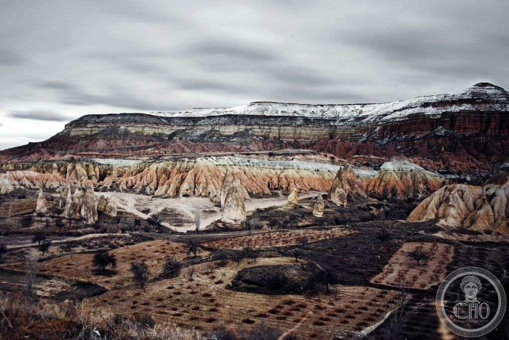
Cappadocia (the most precisely GoremeCappadocia single eroded tuff Erciyes Dağ Hasan Dağ eruptions 2-3 million years ago fairy chimneys peri bacası cave churches 4th century CE Basil of Caesarea hermits Byzantine frescoes Derinkuyu Kaymakli underground cities 85m deep UNESCO heritage: the landscape (the Cappadocia region covers approximately 9,000 km² in central Anatolia; the core Göreme National Park covers 9,575 ha; the landscape consists of: the tuff formations (volcanic ash from the eruptions of the Erciyes Dağ volcano (3,916 m; the highest peak in central Anatolia; extinct but geologically young) and the Hasan Dağ (3,268 m) accumulated 2-3 million years ago in layers hundreds of meters deep; the tuff was then eroded by millennia of rain, frost, and wind into the current landscape of valleys, cones, pillars, and arches)); the cave settlements (the soft tuff can be cut easily with iron tools; the settlements carved into the tuff cliffs and valleys of Cappadocia represent the most extensive concentration of rock-cut architecture in the world; the earliest carvings (storage chambers and simple dwellings) date to the Bronze Age (approximately 2000-1000 BCE); the most extensive rock-cutting was done by early Christian communities from the 4th to 13th centuries CE; the underground cities (Derinkuyu: the deepest discovered, reaching approximately 85m below the surface; 11 levels; space for approximately 20,000 people and their animals; used as refuges during invasions by the Arab armies (7th-11th centuries CE) and by the Mongols (13th century CE))) — the most precisely GoremeCappadocia single eroded tuff Erciyes Dağ Hasan Dağ eruptions 2-3 million years ago fairy chimneys peri bacası cave churches 4th century CE Basil of Caesarea hermits Byzantine frescoes Derinkuyu Kaymakli underground cities 85m deep UNESCO heritage in any UNESCO world heritage site)).
Key facts
- The Göreme Open-Air Museum: the most precisely GoremeCappadocia single Göreme Open Air Museum 4th century Basil Caesarea Dark Church Buckle Church Snake Church frescoes Byzantine Iconoclasm 726 1843 CE well-preserved UNESCO heritage — the most important site within the UNESCO zone: the Göreme Open-Air Museum (a UNESCO core zone covering approximately 1 km²; the densest concentration of carved cave churches in Cappadocia; the principal churches (the Dark Church (Karanlık Kilise; 11th-12th century CE; the best-preserved Byzantine frescoes in Cappadocia because the lack of windows limited the photo-oxidation of the pigments; the scenes: the Nativity, the Baptism, the Last Supper, the Betrayal of Judas, the Crucifixion, and the Anastasis (Resurrection); the figure style is 11th-century middle Byzantine (gold backgrounds, elongated proportions, formal compositions); the Buckle Church (Tokalı Kilise; 10th century CE; the largest single church in the Göreme complex; the oldest frescoes in Cappadocia (9th-10th century CE) visible in the lower nave; the 10th-century renovation painted over them in the full-narrative Byzantine style); the Snake Church (Yılanlı Kilise; the image of the warrior-saints Theodore and George slaying dragons/serpents with lances; a local legend says the figures represent St. Theodore killing a local dragon that lived in the valley))
- GPS: 38.6430° N, 34.8290° E
History
From Hittite kingdom to Byzantine hermitage to Ottoman backwater (the most precisely GoremeCappadocia single Hittite 2000 BCE Croesus Persian Darius Alexander Great Pompey Roman Cappadocia 17 CE province Basil Caesarea 4th century CE hermit community Arab raids 7th century underground cities Seljuk 1071 Ottoman Safavid Georgian community 1923 population exchange UNESCO heritage: the Hittites and Persians (the region has been continuously inhabited since the Chalcolithic period (approximately 5000-3000 BCE); the Hittite empire (approximately 1700-1200 BCE) controlled Cappadocia from Hattusa (100 km north; now Boğazköy); the Persian empire (Cyrus the Great, Darius I) controlled Cappadocia after 547 BCE; the name Cappadocia (in ancient Persian: Katpatuka, meaning “land of beautiful horses”; the region was famous for its horse-breeding; the tribute paid by Cappadocia to the Persian king included 1,500 horses, 2,000 mules, and 50,000 sheep per year)); the Byzantine period (the most important historical period for the landscape: in the 4th century CE, Basil of Caesarea (330-379 CE; one of the three Cappadocian Fathers of the Church; Bishop of Caesarea (modern Kayseri)) organized the hermit communities scattered in the Göreme valley into organized monasteries; the Byzantine iconoclasm controversy (726-843 CE) drove many icon-revering monks from Constantinople to the remote caves of Cappadocia; the most beautiful frescoes in the Göreme churches date to the post-iconoclasm period (843-1071 CE)); the Arab and Mongol invasions (the underground cities (Derinkuyu, Kaymakli, and others) were expanded during the Arab raids of the 7th-11th centuries CE and the Mongol invasions of the 13th century CE; the communities retreated underground for weeks or months with their animals and food stores); the modern period (the region was largely abandoned and forgotten by Western scholarship until the French priest Guillaume de Jerphanion published his study of the cave churches (Les Eglises Rupestres de Cappadoce) in 5 volumes between 1925 and 1942 CE)) — the most precisely GoremeCappadocia single Hittite 2000 BCE Croesus Persian Darius Alexander Great Pompey Roman Cappadocia 17 CE province Basil Caesarea 4th century CE hermit community Arab raids 7th century underground cities Seljuk 1071 Ottoman Safavid Georgian community 1923 population exchange UNESCO heritage in any UNESCO world heritage site)).
What you see
Valleys, hot-air balloons, and underground cities (the most precisely GoremeCappadocia single Rose Valley Pigeon Valley Love Valley mushroom chimneys hot air balloons sunrise 100 balloons per morning Zelve monastery Uçhisar rock fortress Derinkuyu 11 levels 20000 people UNESCO heritage: the principal zones: the Göreme valley system (the network of valleys (Göreme Valley, Rose Valley (Güllüdere Vadisi; the tuff glows rose-pink at sunrise and sunset; 8 km hike), Pigeon Valley (Güvercinlik Vadisi; the valley walls are honeycombed with dovecotes carved into the tuff; the pigeon droppings were collected as fertilizer for the vineyards), Love Valley (the phallic fairy chimneys; the tallest individual chimney is approximately 30m)); the hot-air balloon flights (Cappadocia is the most famous hot-air ballooning destination in the world; approximately 100 balloons rise at dawn each morning above the valleys (when wind conditions allow); the flights take 1 hour; the view of the rock formations from above is the defining experience of the region; the companies (Royal Balloon, Butterfly Balloons, Voyager Balloons) are the most reputable; approximately €180-250 per person); Uçhisar Castle (a natural tuff peak (approximately 60m above the surrounding plain) with caves carved into every face; the highest point in Cappadocia with panoramic views of the valleys; the fairy chimney landscape is most fully visible from here at sunrise); the underground cities (Derinkuyu (the most impressive; 85m deep; 11 storeys; approximately 600m of passageways; the ventilation shafts; the wells; the stone wheel-doors that could seal individual levels; 1971 CE: rediscovered when a resident of Derinkuyu broke through a wall of his cellar to find a previously unknown passage))) — the most precisely GoremeCappadocia single Rose Valley Pigeon Valley Love Valley mushroom chimneys hot air balloons sunrise 100 balloons per morning Zelve monastery Uçhisar rock fortress Derinkuyu 11 levels 20000 people UNESCO heritage in any UNESCO world heritage site)).
Practical information
- Getting there: Nevşehir Kapadokya Airport (NAV; 45 km from Göreme; Turkish Airlines (THY) from Istanbul Atatürk (IST/SAW; 1h10m; multiple daily flights); Kayseri Airport (ASR; 75 km from Göreme; THY from Istanbul; 1h10m; more frequent flights); transfer (shuttle buses from both airports to Göreme; approximately 1h); by train (Göreme does not have a direct train connection; the Ankara–Konya line connects to Nevşehir only via a multi-hour journey from Konya by bus); the Göreme Open-Air Museum (2.5 km from the center of Göreme village; walkable (30 min uphill) or taxi (5 min); entry approximately ₺1,500 (approximately €40; pricing changes rapidly with inflation); the Dark Church has a separate additional entry fee)); accommodation (cave hotel or kervansaray: the most requested experience; thousands of cave-rooms carved directly into the tuff; price range varies enormously; recommend booking months ahead for the best properties (Esbelli Evi, Museum Hotel)); the balloon booking (must be booked weeks in advance in peak season (April-June and September-October); morning flights are weather-dependent; flights operate approximately 300 days per year; the cancellation policy is full refund if the balloon company cancels due to weather))
Getting there
Fly to Nevşehir (NAV) or Kayseri (ASR), then shuttle to Göreme (1h). Open-Air Museum entry ~€40. Book hot-air balloon flights months ahead. GPS: 38.6430, 34.8290.
Nearby
- Derinkuyu Underground City — 30 km south (the deepest underground city in Cappadocia; 11 levels; 85m deep; entry approximately ₺750; take a torch; the passages are narrow; not recommended for claustrophobics; 1971 CE discovery; the second-largest underground city (Kaymakli) is 10 km north of Derinkuyu))
- Alaçatı and Ihlara Valley — 40 km west (the Ihlara Valley: a 14 km river canyon carved by the Melendiz River into the tuff plateau; 105 cave churches carved into the canyon walls (many with frescoes); the hike from Ihlara village to Selime Monastery (the largest cave monastery in Cappadocia; a complete rock-cut monastery complex with church, refectory, kitchen, stables, and cells) takes 3-4 hours))
Sources
- Wikipedia, Cappadocia; Göreme National Park; Derinkuyu underground city, accessed June 2026
- UNESCO, Göreme National Park and the Rock Sites of Cappadocia, WHS reference 357, inscribed 1985
Find it on the map
See this place and what’s around it →📷 Diventa un fotografo di Cultural Heritage Online
Condividi le tue foto dei luoghi: restano pubblicate con la tua firma come autore. Più vengono viste, più ti fai conoscere — e presto un concorso premierà le foto più apprezzate.
Accedi o registrati gratis per aggiungere una foto