Costiera Amalfitana — la Costa più Bella del Mondo tra Positano e Vietri sul Mare: Agrumeti, Torri Saracene e il Porto di Amalfi (UNESCO 1997)
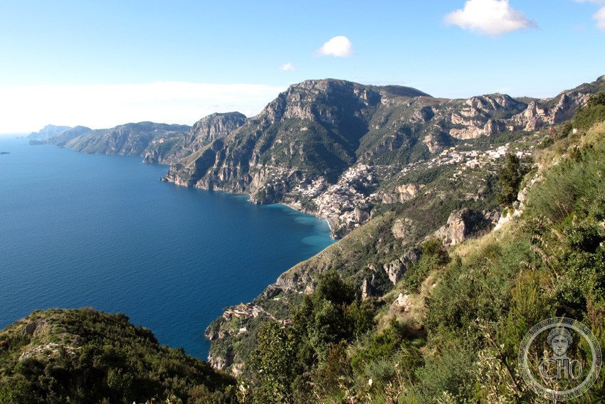
The Amalfi Coast is a 50-kilometre stretch of southern Italian cliff between Positano and Vietri sul Mare where the limestone massif of the Lattari mountains falls directly into the Tyrrhenian Sea — a coast without beaches, almost without flat land, where the entire human settlement (including Amalfi, which was once the fourth maritime republic of medieval Italy, a naval and commercial power equal to Genoa, Venice, and Pisa) is built on the cliff face, among lemon groves and terraced gardens and saracen watchtowers, at a gradient that still has no road alternative for much of its length, only a vertiginous single-lane highway cut into the limestone.
At a glance
The Amalfi Coast (Costiera Amalfitana) is a UNESCO World Heritage Site inscribed in 1997 (ref. 830), covering the stretch of the Campanian coast between Positano (Salerno) and Vietri sul Mare, including the town of Amalfi, the village of Ravello, the Vallone del Furore, and the peninsula of Conca dei Marini. The 50 km of coast is one of the most dramatic coastal landscapes in Europe — limestone cliffs up to 1,400 m high falling directly to the sea, with the only habitable land in narrow valleys and on cliff-ledge terraces. The cultural landscape is defined by the millennial interaction of human settlement with the steep terrain: the terraced lemon groves (sfusato amalfitano, the only variety cultivated on the coast since at least the 13th century), the saracen towers (medieval watchtowers against North African pirate raids), the painted ceramic tiles of the villas and staircases, and the historic center of Amalfi itself.
Key facts
- Republic of Amalfi: The Republic of Amalfi (839-1131 CE) was the first of the four Italian maritime republics to develop a major commercial network in the eastern Mediterranean; it established the first maritime law code in Europe (the Tavola Amalfitana, in use across the entire Mediterranean from the 11th to the 17th century); at its peak (10th-11th century), Amalfi had approximately 50,000 inhabitants and traded directly with Constantinople, Alexandria, and the Arab world; it was conquered by the Normans in 1131 and never recovered its political independence
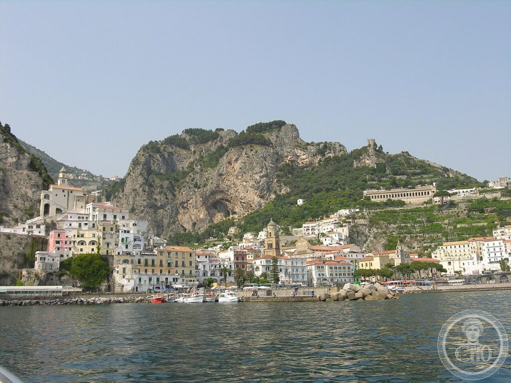
- Cathedral of Amalfi (Sant’Andrea): Founded in the 9th century CE; the current Arab-Norman Romanesque exterior (the 9th-13th century structure, with the striped black-and-white Moorish arches) was altered in the 18th century and the neo-Romanesque facade re-installed in 1891-1893; the Chiostro del Paradiso (Paradise Cloister, 1266-1268) with its distinctive pointed-arch arcade is the most photographed medieval space in the city; the Romanesque bronze doors (1066 CE, cast in Constantinople) are the oldest surviving bronze doors in Italy
- Ravello: A hillside village above Amalfi (365 m altitude, accessible by road from Amalfi 7 km); Villa Rufolo (13th century; the garden overlooking the sea is where Wagner composed the “Transformation of Klingsor’s Garden” in Parsifal in 1880); Villa Cimbrone (late 19th century; the Belvedere of Infinity terrace with the row of bust sculptures overlooking the sea is the most photographed viewpoint on the Amalfi coast); the Ravello Festival (annual music festival in the garden of Villa Rufolo)
- Positano: The most-photographed town on the Amalfi coast; built on a cliff above a small beach; the coloured houses descend steeply to the water; the Church of Santa Maria Assunta (Romanesque, 12th century; the green-and-yellow majolica dome is visible from the sea)
- UNESCO: 1997, ref. 830 — “Costiera Amalfitana”
- GPS: 40.6340, 14.6027 — Google Maps
History
Amalfi was founded as a Roman settlement in the 6th century CE and developed into an independent duchy in 839 CE, when the local population expelled the Lombard duke and established a self-governing maritime republic. For the next 300 years (839-1131 CE), Amalfi was the dominant commercial power in the central Mediterranean — trading between the Arab caliphates (Egypt, Syria, Tunisia) and the Byzantine Empire on one hand, and the cities of northern Italy on the other; its merchants established their own colonies (the fondaci) in Constantinople, Alexandria, Antioch, and Acre, and carried trade goods (spices, silks, gold) that the rest of Europe could not obtain directly. The Tavola Amalfitana (the Amalfi maritime law code, extant in the 13th-century copy now in the Museo della Bussola in Amalfi) was the standard reference for commercial and admiralty law across the Mediterranean basin from the 11th to the 17th century.
The decline of Amalfi began with the Norman conquest (1131) and was accelerated by the sack of Pisa (1135, 1137) and a tsunami (1343) that destroyed the lower part of the city, including most of the harbour infrastructure. By the 16th century, Amalfi was a small provincial town under the Kingdom of Naples; the population had fallen from approximately 50,000 to approximately 5,000. The “rediscovery” of the Amalfi coast by Grand Tour travellers in the late 18th century (the German painter Jacob Philipp Hackert was among the first to document the coast in oil paintings, 1784-1793) and by the Romantic writers (Goethe, Byron, Wagner) in the 19th century began the transformation of the coast into a luxury tourism destination.
What you see
The Amalfi Coast is experienced primarily from the SS163 (the Strada Statale Amalfitana, the single-lane road cut into the cliff that connects all the towns from Positano to Vietri), which offers continuous views over the sea from the coastal settlements at the cliff edge — but the road is extremely narrow, frequently closed by rockfall or landslide, and very crowded in summer (the combination of tourist buses, local delivery vehicles, and private cars on a road designed for horse traffic makes progress very slow). The best way to experience the coast is by boat (from Amalfi, ferries connect all the coastal towns and the islands of Capri and Ischia).
Within Amalfi itself, the most important space is the Piazza del Duomo — a cathedral staircase that descends directly from the facade of the Cathedral to the main piazza and the sea beyond; the view from the top of the staircase (looking down at the piazza, the coloured facades, and the sea) is one of the most familiar images of southern Italy. The Cathedral interior (accessible via the cloister) contains the bronze doors (1066, Constantinople) and the Baroque interior (17th century, remodelled over the original Romanesque structure) with the tomb of St. Andrew the Apostle in the crypt (the bones of St. Andrew were brought from Constantinople by a Crusader ship in 1208).
Gallery
Practical information
- Getting around: The SITA bus (the public bus that connects all the coastal towns on the SS163) is the most practical transport; the service runs frequently in season (every 20-30 min, Salerno/Amalfi/Positano direction) but the buses are typically full in July-August; standing only in peak hours. Ferries (Travelmar, Caremar) connect Amalfi, Positano, Maiori, and Salerno (April-October); recommended in summer when the bus is overcrowded.
- Season: October-November and April-May are best (mild temperatures, fewer crowds). July-August: the SS163 is virtually closed to private cars on summer weekends (traffic restrictions in effect July-August); the towns are extremely crowded (Positano has approximately 4,000 residents and 5,000+ overnight visitors in July).
- Duration: Minimum 2 days to experience Amalfi + Ravello + Positano + boat to Capri. A week allows exploration of the lesser-known valleys (Valle dei Mulini above Amalfi; the Vallone del Furore; the Path of the Gods footpath between Bomerano and Positano).
Getting there
Amalfi (SA), Campania. By bus: SITA from Salerno (55 km; 1h30) and from Sorrento (40 km; 1h via the SS163, or by Circumvesuviana to Meta and then SITA). By ferry (in season): from Salerno, from Naples (Molo Beverello), and from Capri. By car: from Salerno, SS163 (Salerno-Amalfi, 30 km, 40 min in light traffic, 2h in summer traffic). Amalfi has extremely limited parking; the public car park at the entrance to the town fills by 9:00 in summer. The nearest train station is Salerno (Trenitalia from Napoli 40 min, from Roma 2h30).
Nearby
- Ravello — 7 km above Amalfi by road (or 4 km by staircase footpath from Amalfi); Villa Rufolo (1270, garden where Wagner wrote Parsifal, 1880; annual Ravello Festival July-September); Villa Cimbrone (Belvedere of Infinity with the row of classical busts overlooking the sea — the most photographed viewpoint on the coast); the Duomo di Ravello (1086, with 12th century bronze doors and an important Cosmati mosaic pulpit)
- Grotta dello Smeraldo — 4 km west of Amalfi; an accessible sea cave with a turquoise-green light effect from underwater light refraction; entered by lift from the SS163; notable for the submerged Nativity scene added in 1956 (the original was in a boat on the cave floor — the sea rose 2-3m since medieval times)
- Pompei e gli scavi — 40 km north-east via the SS366 and the A3; (see separate CHO card for the full entry)
Sources
- UNESCO: whc.unesco.org/en/list/830
- Wikipedia EN: Amalfi Coast
- Pane, Roberto: Architettura rurale campana, Rinascimento del Libro, Firenze, 1936
- Comune di Amalfi: amalfi.it
Find it on the map
See this place and what’s around it →📷 Diventa un fotografo di Cultural Heritage Online
Condividi le tue foto dei luoghi: restano pubblicate con la tua firma come autore. Più vengono viste, più ti fai conoscere — e presto un concorso premierà le foto più apprezzate.
Accedi o registrati gratis per aggiungere una foto