
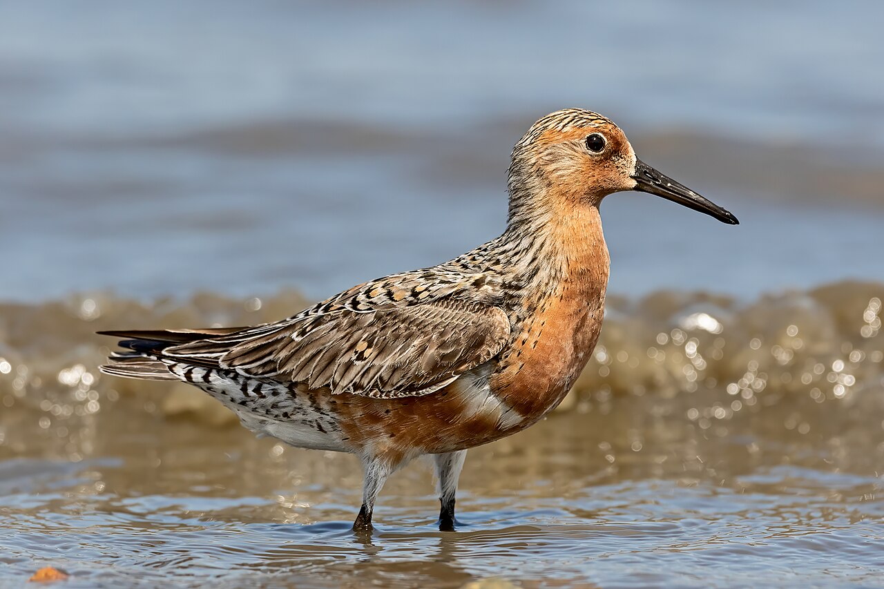
The Migratory Bird Sanctuaries along the Coast of Yellow Sea–Bohai Gulf (Phase I inscribed 2019, Phase II 2023) covers intertidal and coastal habitats across Jiangsu, Liaoning, Shandong, Tianjin and Hebei Provinces, collectively supporting an estimated 5.5 million migratory birds per year on the East Asian–Australasian Flyway (EAAF), which runs between Siberian and Alaskan breeding grounds and Australian and New Zealand wintering areas. Since the 1950s, an estimated 70% of tidal flat habitat in the Yellow Sea region has been lost to coastal reclamation projects. The bar-tailed godwit (Limosa lapponica baueri), which refuels on the Yellow Sea tidal flats before making a non-stop flight to its Alaskan breeding grounds, covers 11,000 kilometres in approximately nine days without landing.
Getbol and the Korean component of the same flyway ecosystem 300 km east across the Yellow Sea; accessible by air or ferry from Tianjin/Qingdao
Getbol, Korean Tidal Flats (UNESCO 2021), is the South Korean component of the same East Asian–Australasian Flyway ecosystem as the Yellow Sea–Bohai inscription, inscribed two years later by a different state but covering continuous habitat in the same intertidal system across the Yellow Sea. The Yellow Sea is a shallow shelf sea—average depth 44 metres, maximum 103 metres—and the tidal flats on its Chinese western shore and Korean eastern shore are ecologically continuous: the same species of shorebird, including the spoon-billed sandpiper (Calidris pygmaea; total world breeding population estimated at fewer than 300 pairs), the great knot (Calidris tenuirostris; listed Critically Endangered on the IUCN Red List), and the red knot (Calidris canutus piersmai subspecies), use both shores as refuelling habitat within the same migration season. The four Getbol components—Seocheon, Gochang, Shinan and Boseong-Suncheon—collectively cover 1,285 square kilometres of intertidal mudflat and record approximately 1.5 million migratory birds per season. The scientific monitoring connection between the two inscriptions is direct: researchers tracking individual shorebirds with geolocators and flag bands have documented specific birds using Chinese Phase I sites (the Jiangsu intertidal flats near Yancheng) and then, within the same northbound migration spring, using the Gochang or Seocheon components of Getbol within one to two weeks. The ecological unit is the flyway, and the administrative division between Chinese and Korean inscriptions corresponds to no meaningful ecological boundary. Physical access from the Chinese Yellow Sea coast to the Korean Getbol sites requires crossing the Yellow Sea: ferry services operate from Tianjin Xingang and Qingdao to Incheon (South Korea) and take 24–26 hours; air connections from Tianjin, Qingdao or Nanjing to Seoul Incheon take 2 hours, with intercity bus from Seoul to the Seocheon or Gochang Getbol components (2 hours 30 minutes to 3 hours). The most ecologically productive visiting period for shorebird observation at the Yellow Sea–Bohai flats is late April to late May (northbound spring migration), when the flats host the highest concentration of individuals and the greatest diversity of species in a single season.
The migratory bird concentration on the Yellow Sea–Bohai flats during spring migration is driven by a specific physiological constraint. Shorebirds on the EAAF need to refuel before the non-stop flight from the Yellow Sea coast to their Siberian and Alaskan breeding grounds. The red knot (Calidris canutus) of the piersmai subspecies, which breeds on the New Siberian Islands in the Russian Arctic, stages on the Chinese mudflats where it consumes bivalves, polychaete worms and other invertebrates in quantities sufficient to double its body weight from approximately 125 grams to 250 grams over 10–14 days. The extra weight is entirely fat, which is metabolised during the non-stop flight of approximately 4,000–6,000 kilometres. Upon arriving at the breeding ground, the bird is too weak to forage immediately and rests for 24–48 hours before beginning territorial behaviour. The Rudong and Dongtai tidal flats in Jiangsu Province (Phase II inscription, 2023) are the single most important staging site for this subspecies; invertebrate density surveys at Rudong have recorded up to 10,000 individuals per square metre of benthic invertebrates, among the highest densities recorded in any intertidal system globally. The loss of 70% of Yellow Sea tidal flat area since 1950—estimated from satellite analysis comparing 1950 and 2015 coastal surveys—has concentrated the remaining shorebird populations on a shrinking resource base, increasing the energetic cost of foraging per individual and reducing the proportion of birds arriving at breeding grounds in condition to breed successfully.
Mogao Caves, Qinghai Hoh Xil, and Shennongjia: the flyway’s inland connections 600–2,000 km inland from the Yellow Sea coast
The Mogao Caves (UNESCO 1987) at Dunhuang, Gansu Province, lie 2,000 kilometres west of the Yellow Sea coast (approximately 2 hours by air from Nanjing or Beijing to Dunhuang Airport). The connection to the Yellow Sea migratory bird inscription runs through climate rather than direct ecology: the Hexi Corridor desert that Dunhuang’s Silk Road oasis served for 1,600 years is fed by glacial meltwater from the Qilian Mountains to the south; those glaciers are contracting at rates measured by glaciologists at approximately 0.5–1.0% of volume per year since 1950, driven by the same global temperature increase that is altering precipitation patterns along the Yellow Sea coast and contributing to sea surface temperature changes that affect the invertebrate prey populations on the tidal flats. The Mogao Caves themselves contain 492 decorated chambers carved into a sandstone cliff 1,600 metres long, with 45,000 square metres of surviving wall paintings and approximately 2,000 painted clay sculptures, produced between the 4th and 14th centuries CE. The caves functioned as a religious and cultural centre for the communities that managed the Silk Road oasis economy. While not ecologically linked to the Yellow Sea flyway, Mogao provides the cultural and historical context for the broader landscape of northwestern China that any visitor tracing the flyway inland from the coast will eventually reach. The caves’ physical fragility (desert desiccation cracks in the painted surfaces when humidity changes; visitor breath introduces moisture that damages pigments) has prompted the Dunhuang Academy to implement strict visitor number controls since 2014: the standard daily visitor cap is 6,000 (reduced from 20,000); advance booking is required for entry, and access to the most significant painted caves (such as Cave 17, the Library Cave where Aurel Stein removed approximately 40,000 manuscripts in 1907, and Cave 96, which contains the nine-storey wooden facade built to house a 33-metre clay Buddha) requires timed group tours of a maximum of 25 people.
Qinghai Hoh Xil (UNESCO 2017) is a 4.5-million-hectare expanse of the Tibetan Plateau in the Qinghai Province, inscribed for its exceptional biodiversity and its role as the breeding ground of the Tibetan antelope (Pantholops hodgsonii, chiru), one of the fastest-running large mammals at elevation. For the Yellow Sea migratory bird inscription, Hoh Xil matters as the origin point of bar-headed geese (Anser indicus) and black-necked cranes (Grus nigricollis) that breed on the plateau’s wetland lakes and winter on the Yellow Sea coast and in the Yangtze River lowlands. The bar-headed goose is the highest-flying migratory bird regularly documented: it crosses the Himalayas at altitudes up to 7,290 metres (documented by GPS logger in 2011), utilising jet stream winds and the anoxic conditions at extreme altitude through physiological adaptations including haemoglobin with an unusually high oxygen-binding affinity at low partial pressure. Hoh Xil is 2,000 kilometres west of the Yellow Sea coast (no direct rail; access is via Golmud, 6 hours by HSR from Xining, and then by road convoy into the reserve, which requires permits from the Qinghai Wildlife Conservation Bureau). The practical result for planning is that Hoh Xil cannot be combined with the Yellow Sea coast in a short visit; it is a separate multi-day expedition destination. Its connection to the Yellow Sea inscription is conceptual—source habitat in the bird-breeding cycle versus refuelling habitat in migration—rather than geographic.
Shennongjia (UNESCO 2016) covers 79,343 hectares of montane forest in northwestern Hubei Province, 600 kilometres south of the Yellow Sea coast (5 hours by HSR from Nanjing to Badong or Yichang, then 2 hours by road to the Shennongjia core area). The site is inscribed for its biodiversity values, specifically the high proportion of endemic plant species (near 1,000 endemic plant species in the inscribed area, out of approximately 3,700 total) and for the role of its primary forest as a migration corridor for bird species moving between the coast and the interior. The north-south migration of passerine birds (warblers, flycatchers, thrushes, buntings) through central China uses forest corridors such as Shennongjia as stepping-stone habitats: small songbirds cannot make long overwater crossings and depend on continuous or near-continuous forest cover between coastal wintering areas and inland breeding sites. The Shennongjia primary forest, at elevations between 400 and 3,105 metres (the summit of Shennong Peak), provides both nesting habitat for resident species and stopover shelter for passage migrants. Shennongjia is also the site of China’s largest recorded relict Quaternary (Pleistocene) forest stands—trees over 500 years old in undisturbed primary forest—and contains populations of the Sichuan snub-nosed monkey (Rhinopithecus roxellana) in its second-highest wild subpopulation outside the Qinling Mountains.
Practical information
The Yellow Sea–Bohai Migratory Bird Sanctuaries inscription covers a linear coastal extent of approximately 1,200 kilometres from northern Liaoning (Shuangtaizi Estuary Nature Reserve) to southern Jiangsu (the Rudong and Dongtai tidal flats). There is no single visitor centre for the inscription as a whole; the most developed visitor infrastructure is at the Yancheng National Nature Reserve in Jiangsu (accessible from Yancheng city, 2 hours by intercity bus from Nanjing), which has a visitor centre, observation towers and guided birdwatching programmes. The Bohai Bay component (Tianjin and Hebei sites) can be reached from Beijing by HSR to Tianjin (30 minutes) then coastal road.
Spring migration (late April to late May) is the peak period for shorebird numbers; autumn migration (July to September) has a longer spread with lower peak concentrations. Winter (November to February) brings large concentrations of wildfowl (ducks, geese) to the Bohai Bay sites but shorebird diversity is lower. Birdwatching guides from Chinese conservation organisations (including the China Birdwatching Society, CBWS) offer site-specific trip reports and seasonal abundance charts online; the CBWS website publishes an annual flyway monitoring report with site-specific bird counts from the Chinese components of the inscription.
Frequently Asked Questions
Why is land reclamation on the Yellow Sea coast so destructive to shorebirds specifically?
Tidal flats are productive as bird foraging habitat because of their intertidal position—the zone alternately exposed at low tide and submerged at high tide—which concentrates invertebrate food in a strip that is accessible to birds during part of every tidal cycle. Shorebirds cannot dive to forage underwater; they probe and pick from the surface of exposed mud. The intertidal zone is thus not merely one of many habitats available to these species, but the only foraging habitat consistent with their morphology. When tidal flat is reclaimed by building a seawall and pumping out the water to create dry land, the foraging habitat does not move elsewhere: it is permanently eliminated, and the invertebrate community within it is killed. This is categorically different from, for example, the conversion of forest to farmland, which degrades habitat quality but typically allows some remaining plant structure; tidal flat reclamation eliminates the habitat completely. The 70% loss of Yellow Sea tidal flat area since 1950 documented in satellite analyses means that the surviving shorebird populations—which have declined correspondingly in most species—are competing for access to the remaining 30% of their original refuelling habitat. For species such as the spoon-billed sandpiper with a total world population under 1,000 individuals, the remaining tidal flat area is insufficient to support population recovery even without additional mortality from hunting, bycatch or climate-driven prey changes. The Yellow Sea–Bohai inscription was partly a response to this documented trajectory: by formalising the outstanding universal value of the remaining tidal flat, the inscription creates an international legal and political argument against further reclamation of the specific inscribed areas. It does not protect non-inscribed tidal flats, and significant reclamation continues outside the inscription boundaries.
What is the East Asian–Australasian Flyway and how does it compare to other global flyways?
A flyway is a broad corridor used by populations of migratory birds travelling between their breeding and wintering grounds, typically defined by shared geographic bottlenecks—river deltas, coastal staging areas, mountain passes—through which many individual birds pass. The East Asian–Australasian Flyway (EAAF) runs between breeding grounds in northeastern Siberia, Alaska and the high Arctic, and wintering areas in Australia, New Zealand and Southeast Asia, with the Yellow Sea coast as the primary mid-flyway refuelling zone for most of the shorebird species using this route. The EAAF is the most threatened of the world’s nine major flyways for migratory waterbirds: systematic surveys conducted by the EAAF Partnership (a multinational conservation organisation established in 2006) document population declines in 31 of 36 shorebird species using the flyway, with 17 species listed as Threatened or Near Threatened on the IUCN Red List. The Atlantic Americas Flyway (connecting the Canadian Arctic to Patagonia) and the Central Americas Flyway show different species compositions but comparable structural logic: coastal wetlands as refuelling habitat at migration waypoints. The Pacific Americas Flyway (from Alaska to southern South America) uses Pacific coast tidal habitats including Delaware Bay (for the horseshoe crab egg foraging by red knots) as the North American equivalents of the Yellow Sea staging areas. The difference in conservation status is partly a product of land tenure and legal protection: tidal flats on the East Asian coast are treated as “wasteland” in some regulatory frameworks and eligible for reclamation without environmental impact assessment requirements, whereas wetland protections in the United States and western Europe have reduced reclamation rates in those regions since the 1970s. The Yellow Sea–Bohai UNESCO inscriptions and the Getbol Korean inscription are the principal international legal protections for the EAAF’s critical mid-flyway staging areas.
How can birdwatchers plan a visit to observe migratory shorebirds on the Yellow Sea tidal flats?
Planning a productive shorebird observation visit to the Yellow Sea coast requires advance preparation on three variables: timing, site selection, and access logistics. Timing is determined by the migration calendar: northbound spring migration peaks between late April and late May, when knots, godwits, sandpipers and plovers are present in the largest numbers and in breeding plumage (more visually distinctive than the drab non-breeding plumage of autumn). The single most important visit window is the 10-day period centred on 5 May, when peak numbers of multiple species typically overlap. Site selection within the Yellow Sea–Bohai inscription varies by target species: the Rudong and Dongtai tidal flats in Jiangsu Province (Phase II inscription, 2023) are the primary staging area for great knot and red knot piersmai and are closest to Shanghai (3 hours by HSR to Yancheng or by road to Rudong); the Yancheng National Nature Reserve in Jiangsu supports red-crowned cranes in winter (October to March) and black-faced spoonbills at migration staging; the Shuangtaizi Estuary in Liaoning (Phase I) is the principal staging area for bar-tailed godwits. Access logistics: most Chinese tidal flat nature reserves require a visitor permit from the local environmental authority (typically the county-level Ecology and Environment Bureau) and do not have walk-in visitor facilities comparable to European or North American birdwatching sites. The most efficient approach for visiting birdwatchers is to contact the China Birdwatching Society (chbird.org) or BirdingBeijing (a commercial guiding company) in advance; both organisations offer guided group visits with local ornithologists who know current access requirements, have existing relationships with reserve staff, and carry spotting scopes and identification references. Independent access without a local contact is possible at some sites (the Yancheng visitor centre has standard tourist infrastructure) but is significantly more difficult at the core tidal flat areas where the highest shorebird concentrations occur.
Sources
- S1 — UNESCO World Heritage Centre — Migratory Bird Sanctuaries along the Coast of Yellow Sea-Bohai Gulf of China (Ref. 1606) — https://web.archive.org/web/20230601000000/https://whc.unesco.org/en/list/1606/
- S2 — National Forestry and Grassland Administration China — https://whc.unesco.org/en/list/1606/
- S3 — Seidensticker, John. <em>Riding the Tiger: Tiger Conservation in Human-Dominated Landscapes</em>. Cambridge University Press, 1999. ISBN: 978-0-521-64835-6.
Spotted an error? Write to editorial@culturalheritageonline.com and we correct it the same day.



_in_Delaware_Bay,_New_Jersey.jpg)