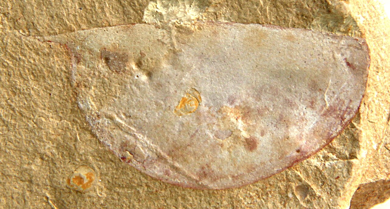
The Chengjiang Fossil Site (UNESCO 2012) covers 512 hectares in Chengjiang County, Yunnan Province, 52 kilometres south of Kunming by road or 30 minutes by high-speed rail. The site preserves soft-tissue fossils of marine animals from the early Cambrian period, dated to approximately 518 million years ago, in the fine-grained mudstone and siltstone of the Maotianshan Shale Formation. Since the first scientific collection in 1984 by palaeontologist Hou Xianguang, over 20,000 specimens representing 228 species have been documented from Chengjiang, including representatives of nearly every animal phylum known from the modern oceans.
From Cambrian limestone to living karst: the Stone Forest and the 500-million-year geological sequence near Kunming 100–200 km from Kunming by road
The South China Karst (UNESCO 2007, extended 2014) encompasses a serial inscription distributed across Yunnan, Guizhou and Guangxi provinces; the component most accessible from Kunming and the Chengjiang fossil site is the Shilin Stone Forest cluster in Shilin County, 85 kilometres southeast of Kunming (high-speed rail to Shilin from Kunming South Station, 30 minutes; or intercity bus from Kunming East Bus Station, 1 hour 30 minutes). The Shilin stone columns—limestone pinnacles between 2 and 40 metres tall, separated by narrow passages and small lakes—formed from shallow marine limestone deposited approximately 270 million years ago during the Permian period, then dissolved over the subsequent 200 million years by slightly acidic groundwater percolating through fractures in the rock. The process that shaped Shilin is thus a direct continuation of the geological story that Chengjiang begins: the shallow Cambrian sea in which Chengjiang’s animals died and were preserved under anaerobic conditions (518 million years ago) was replaced by later shallow seas in which coral reefs and carbonate sediments accumulated through the Ordovician, Silurian, Devonian and Permian; those carbonate sediments became the limestone that dissolution carved into the Stone Forest starting approximately 65 million years ago, after the Tibetan Plateau uplift began redirecting drainage patterns across Yunnan. Visiting Chengjiang and Shilin in sequence thus traces a 450-million-year chapter of the same geological landscape: the Maotianshan Shale in which the fossils are preserved underlies the Permian limestone at depth, and the regional topography visible today is the late product of the tectonic events set in motion during the same Cambrian period whose biology Chengjiang records. The Shilin inscription area covers 1,100 square kilometres and includes four landform types: the Naigu Stone Forest (black limestone pinnacles up to 35 metres, accessible by walking path), the Suogeyi Stone Forest (older, more eroded columns with a more open structure), the Zhiyun Cave (an active cave system with stalactites and underground lake), and the Changhu Lake (a shallow karst lake with exposed limestone formations at the water surface). The Sani people of the Yi ethnic group have inhabited the Shilin area continuously for approximately 1,000 years and use the stone forest as the setting for an annual Torch Festival (24th and 25th day of the 6th lunar month, typically July) that involves wrestling, bullfighting, and singing competitions among the pinnacles.
The Cultural Landscape of Honghe Hani Rice Terraces (UNESCO 2013) is 200 kilometres south of Kunming by road (2 hours 30 minutes by expressway to the Yuanyang area, with the most photographed terrace sections at Duoyishu and Bada). The terraces cover 16,603 hectares of steep hillside in the Ailao Mountains above the Red River (Honghe) valley, constructed and maintained by the Hani people over an estimated 1,300 years. The terrace system operates through a gravity-fed irrigation network in which water collected from montane forests above the villages flows down a sequence of channels through the inhabited terraces and eventually into paddy fields in the lowest zones; the entire system functions without pumps, with the forest canopy maintaining the water table that feeds the springs at the irrigation network’s source. The Hani agricultural calendar divides the year into five seasons corresponding to cultivation phases rather than meteorological seasons, and each phase is marked by collective rituals that regulate water allocation, seed selection and harvest timing across the 82 villages inscribed in the UNESCO area. The geological connection to Chengjiang runs through the Ailao Mountains themselves: the range is a major structural feature of the Yunnan metamorphic belt whose uplift—associated with the Cenozoic collision of the Indian and Eurasian plates, the same tectonics that pushed up the Tibetan Plateau—created the drainage conditions that both exposed the Chengjiang Maotianshan Shale at the surface and carved the Red River gorge system in which the Hani terraces sit.
Three Parallel Rivers and Lijiang: geology and culture of northwestern Yunnan 350–400 km northwest of Kunming by HSR and road
Three Parallel Rivers of Yunnan Protected Areas (UNESCO 2003) covers 1.7 million hectares in Yunnan’s northwest, where the Jinsha (upper Yangtze), Lancang (upper Mekong) and Nu (upper Salween) rivers run within 65 kilometres of each other through gorges 3,000 metres deep before diverging to flow into the Pacific, South China Sea and Indian Ocean respectively. The site is 400 kilometres northwest of Kunming (5 hours by road to the Lijiang or Shangri-La area, which serves as the practical base for entering the Three Parallel Rivers area). The parallel rivers phenomenon results from the same late Cenozoic tectonic uplift that is directly connected to the Chengjiang fossil site’s geological setting: before the Tibetan Plateau began its major phase of uplift approximately 25 million years ago, the Jinsha, Lancang and Nu rivers flowed in significantly different directions, draining a more gently sloping landscape. The progressive uplift of the plateau—now averaging 4,500 metres elevation and still rising at approximately 5 mm per year—reorganised the river systems, redirecting them southward into the parallel gorge configuration. The Three Parallel Rivers area spans an elevation range from 760 metres in the valley bottoms to 6,740 metres at the summit of Kawakarpo (Meri Snow Mountain), encompassing 20 different vegetation zones and containing approximately 25% of China’s total animal species diversity and 20% of the higher plant species in a single inscribed area. The Hengduan Mountains that form the gorge system are the world’s most species-diverse temperate region outside the tropics; the concentration results from the area’s role as a Pleistocene glacial refugium, where species survived ice ages in valley bottoms that remained ice-free while surrounding elevations were glaciated. The Chengjiang connection here is evolutionary rather than geological in the narrow sense: the animal phyla that appear for the first time in the Chengjiang fauna 518 million years ago are the ancestral lineages of the vertebrates, arthropods, molluscs and echinoderms that have since radiated into the Three Parallel Rivers’ extraordinary species diversity. The Chengjiang site records the moment of origin; the Three Parallel Rivers area records the present-day outcome of 518 million years of diversification.
The Old Town of Lijiang (UNESCO 1997) is the cultural heritage counterpart to Yunnan’s natural inscriptions, 350 kilometres northwest of Kunming (3 hours 30 minutes by high-speed rail from Kunming South to Lijiang on the Yunnan–Guizhou–Guangxi HSR network). Lijiang is the historic centre of the Naxi people, a Tibeto-Burman ethnic group whose traditional territory spans the Hengduan Mountains gorge country at elevations between 2,400 and 3,000 metres. The inscribed historic town covers the Dayan Quarter, a settlement of approximately 30,000 people built without a city wall (unique among Chinese historic towns at this scale) and arranged along a network of stone-paved lanes above three water channels diverted from the Yulong Snow Mountain watershed. The Naxi Dongba script—a pictographic writing system with approximately 1,400 symbols, the only pictographic script still in active use in the 21st century by a living community—is used to record the Naxi religious literature (dongba scriptures) that governs ritual practice. Lijiang was severely damaged by an M7.0 earthquake in February 1996, 14 months before its UNESCO inscription; the inscription was granted in 1997 partly in recognition of the reconstruction effort that restored traditional Naxi building techniques rather than replacing them with concrete construction. The town sits at 2,400 metres elevation with views of Yulong Xueshan (Jade Dragon Snow Mountain, 5,596 metres) to the north; altitude adjustment of 24–48 hours is advisable before vigorous walking if approaching from Kunming (1,895 metres) or sea level.
Practical information
The Chengjiang Fossil Site Museum (opened 2022, 40,000 square metres) is the primary visitor facility for the UNESCO inscription and is located adjacent to the excavation area in Chengjiang County. The museum holds approximately 16,000 fossil specimens on display, the largest collection of Cambrian soft-tissue fossils in a single institution. The site itself (the Maotianshan hillside excavation area) is accessible by guided visit from the museum; independent access to the active quarry zones is not permitted. From Kunming, the most convenient option is the high-speed rail to Chengjiang North Station (30 minutes from Kunming South) and taxi to the museum (15 minutes). By intercity bus from Kunming East Bus Terminal to Chengjiang town (1 hour 10 minutes), then taxi to the museum (10 minutes).
A logical three-day Yunnan UNESCO circuit from Kunming: Day 1—Chengjiang Fossil Site (half day) + Stone Forest Shilin (afternoon, 85 km southeast of Kunming); Day 2—Hani Rice Terraces at Yuanyang, arriving by overnight bus or early bus from Kunming (the Duoyishu terrace section is best photographed from the viewpoint at sunrise, approximately 6:30–8:00 am); Day 3—return to Kunming and HSR northwest to Lijiang (3h 30m). The Three Parallel Rivers area requires a separate 3–4 day extension from Lijiang or Shangri-La, with road transport into the gorge areas (no HSR).
Frequently Asked Questions
What exactly is the Cambrian Explosion and why does Chengjiang matter to the scientific understanding of it?
The Cambrian Explosion refers to the geologically rapid diversification of animal body plans in the early Cambrian period, approximately 541 to 510 million years ago. Before this interval, the fossil record contains evidence of microbial mats, single-celled organisms, and the soft-bodied organisms of the Ediacaran fauna (approximately 635–541 million years ago), which are of uncertain relationship to modern animal groups. In the early Cambrian, over a span of perhaps 20–25 million years, the fossil record begins to show the skeletal remains of representatives of nearly all modern animal phyla—the fundamental body-plan categories that include arthropods (which today includes insects, crustaceans, and spiders), molluscs, echinoderms (sea urchins, starfish), chordates (the phylum containing vertebrates), annelids and many others. The Chengjiang site matters because it preserves soft-tissue anatomy, not just the hard skeletal elements that most marine fossils record. Hard shells and mineralised skeletons are what normally fossilise; soft tissues—gills, gut structures, eyes, legs, and the general body outline—almost always decay before mineralisation can occur. Chengjiang’s fine-grained anoxic mudstone created conditions in which soft tissues were rapidly coated in iron minerals before bacterial decomposition could destroy them, producing fossils with preserved outlines of internal organs, appendage structure and body shape. This means that Chengjiang specimens can be assigned to phyla with much greater confidence than skeletal fossils, because the diagnostic features of each phylum often lie in soft-tissue anatomy rather than in the mineralised skeleton. The creature Haikouella, discovered at Chengjiang in 1995, shows evidence of a notochord (the precursor to the vertebral column), gill slits, a rudimentary brain, and segmented musculature consistent with the chordate body plan, placing it as a possible ancestor or close relative of the first vertebrates—making it one of the oldest specimens in the lineage that eventually produced fish, amphibians, reptiles, birds, and mammals.
How were the Chengjiang fossils formed, and what made preservation of soft tissues possible?
Soft-tissue preservation in the Maotianshan Shale occurred through a specific combination of depositional conditions that geologists call Burgess Shale-type preservation, named for the earlier-discovered Canadian site in British Columbia (UNESCO 1981, part of the Canadian Rocky Mountain Parks inscription). The Chengjiang animals lived in a shallow marine environment, probably at depths of 20–100 metres, on a seafloor of fine carbonate and siliciclastic sediment at the margin of a continental shelf. Death and burial appear to have occurred by rapid event sedimentation—periodic storms or turbidity currents that swept large volumes of fine sediment over the seafloor, burying organisms quickly enough to prevent the normal sequence of biological decay: scavengers consuming soft tissues, then bacterial decomposition reducing the remaining organic material to dispersed molecules. Once buried below the sediment surface in an anoxic (oxygen-free) environment, soft tissues were progressively replaced by thin films of clay minerals (primarily aluminium silicates) that replicated the tissue surfaces at submicron resolution. The resulting fossils are impressions rather than casts: the original organic material is gone, replaced by a thin, dark film of carbon and clay minerals that retains the shape, texture, and sometimes the cellular structure of the original tissue. Recovery of these specimens in the field requires careful splitting of the fine-grained rock along natural bedding planes; most Chengjiang collection has been done by hand with small hammers and chisels rather than mechanical equipment, because the fossils are thin-film impressions that a single careless blow can destroy. The site covers 512 hectares and excavation occurs in designated research zones; Chinese law prohibits the private collection of fossils at the site.
Can non-specialist visitors understand the Chengjiang site and museum, and what should they expect to see?
The Chengjiang Fossil Site Museum, opened in September 2022, was designed explicitly for general visitor access rather than specialist research use. The building, by Logon Architecture, is embedded into the Maotianshan hillside and its roof profile follows the slope gradient, minimising visual intrusion on the excavation landscape. The exhibition is organised chronologically from the Ediacaran precambrian period forward through the Cambrian, Ordovician and later periods, using large-format fossil displays, interactive reconstructions of Cambrian marine environments, and scale models of representative Chengjiang animals. Many of the most significant specimens on display are at eye level and lit to show the fine detail of preservation; magnifying glass stations are provided at key specimens. The reconstructions are based on peer-reviewed interpretations and are updated as new research revises the understanding of specific animals’ anatomy and ecology. Labels are bilingual (Mandarin and English). What visitors should realistically expect: the fossils themselves are subtle. Unlike dinosaur fossils—large, three-dimensional, immediately recognisable—Chengjiang specimens are typically small (5 to 80 mm long), two-dimensional impressions on dark grey or reddish stone. The aesthetic impact comes from understanding what you are looking at: a 5-millimetre shrimp-like creature preserved 518 million years ago with its feeding appendages and digestive tract intact. The museum’s interpretive approach is effective at providing this context. Allow 2–3 hours for the museum and a guided walk to the excavation viewpoint; the site is higher altitude than Kunming (1,895 metres) and the Maotianshan hillside is at approximately 2,000 metres, requiring normal fitness for the uphill path.
Sources
- S1 — UNESCO World Heritage Centre — Chengjiang Fossil Site (Ref. 1388) — https://web.archive.org/web/20230601000000/https://whc.unesco.org/en/list/1388/
- S2 — Chengjiang Fossil Site Natural Heritage Museum — https://whc.unesco.org/en/list/1388/
- S3 — Klein, Richard G. <em>The Human Career: Human Biological and Cultural Origins</em>. University of Chicago Press, 2009. ISBN: 978-0-226-43965-5.
Spotted an error? Write to editorial@culturalheritageonline.com and we correct it the same day.