
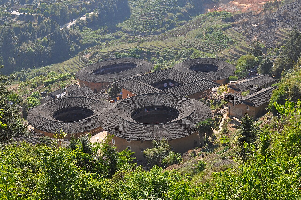
The Fujian Tulou were inscribed as UNESCO World Heritage in 2008, covering 46 earthen communal fortresses in three county clusters: Yongding, Nanjing and Hua’an in Fujian Province. The inscribed property documents construction by Hakka and Minnan communities from the 12th to the 20th century; the total number of surviving tulou across Fujian is approximately 20,000. The largest round tulou, Chuxi Tulou Cluster in Yongding’s Chuxi village, contains a circular building with an outer diameter of 73 metres housing approximately 600 residents across 18 concentric residential rings within a single outer wall 1.8 metres thick and 4 storeys high.
Northeast connections: Kulangyu/Gulangyu Island in Xiamen and West Lake of Hangzhou Gulangyu Island 200 km northeast, 3h bus+ferry from Yongding; West Lake Hangzhou 650 km north, 4h HSR from Xiamen
Kulangyu (Gulangyu Island) in Xiamen, Fujian Province, inscribed as UNESCO World Heritage in 2017, is approximately 200 kilometres northeast of the Yongding tulou cluster, reachable in approximately 3 hours by bus from Yongding County to Xiamen, followed by a ferry crossing of approximately 6 minutes from Xiamen’s Lunchang Ferry Terminal to Gulangyu. Alternatively, visitors can take a bus from the Nanjing tulou cluster to Zhangzhou (1 hour) and then a train or bus to Xiamen (1 hour further). Gulangyu is an island of 1.87 square kilometres designated as an International Settlement under multilateral agreement from 1903, with 13 countries maintaining concessions; the UNESCO inscription recognises its concentration of buildings mixing Chinese courtyard-house planning with European neoclassical, colonial and Art Nouveau architectural vocabularies. The thematic relationship between Gulangyu and the Fujian Tulou is direct: both are products of the same Fujian coastal communities’ engagement with the outside world. The Hakka builders of the Yongding tulou constructed inward-facing defensive communal fortresses in the inland mountain valleys as a response to centuries of social insecurity; their Minnan-speaking coastal counterparts in Xiamen and Zhangzhou built outward-facing hybrid buildings combining Chinese domestic organisation with foreign architectural imagery, financed by overseas trade and emigrant remittances. The Gulangyu inscription includes 931 historic buildings of which 53 are classified as significant monuments, among them the Bagua Building (Octagonal Building, 1907), the Huang Jia Huayuan villa complex (1913), the Roman-Catholic Cathedral of St. Francis of Assisi (completed 1917) and the Former British Consulate (1844). Gulangyu also holds the highest concentration of upright pianos per capita of any island in China, a consequence of European missionary music education programmes operating on the island from the 1880s onward; the island’s Gulangyu Piano Museum houses more than 100 historic instruments dating from the 18th to the 20th century. The contrast between the tulou’s communal round-wall architecture in the inland hills and Gulangyu’s urban treaty-port hybridity on a coastal island illustrates the two dominant modes of Fujian architectural response to external contact across roughly the same historical period.
The West Lake Cultural Landscape of Hangzhou, inscribed as UNESCO World Heritage in 2011, is approximately 650 kilometres north of the Fujian Tulou clusters and reachable in approximately 4 hours by high-speed rail from Xiamen North to Hangzhou East. The West Lake landscape covers 3,323 hectares around a freshwater lake 3.3 kilometres east to west and 3.2 kilometres north to south; its UNESCO inscription recognises the lake’s 1,000-year history of integration between natural landscape, hydraulic engineering works (the Su Causeway of 1089 CE, the Bai Causeway attributed to Bai Juyi’s governorship of 822–824 CE), built pavilions, island temples and pagodas into a single composed aesthetic landscape that subsequently influenced garden design across East Asia. The connection between West Lake and the Fujian Tulou is historical rather than geographic: both sites represent sustained human transformation of a natural environment over centuries through collective effort — the Song-dynasty engineers and governors who dredged, dammed and causewayed West Lake, and the Hakka communities who quarried, rammed and raised the earthen walls of the tulou over five centuries — but the resulting forms are at opposite ends of the spectrum between aestheticised landscape and defensive vernacular architecture. A combined Fujian–Zhejiang itinerary covering the Yongding tulou cluster, the Gulangyu International Settlement in Xiamen, and the West Lake landscape in Hangzhou, supplemented by the Classical Gardens of Suzhou (200 kilometres from Hangzhou by 1 hour HSR), covers five UNESCO inscriptions and approximately 1,000 years of Chinese and Sino-foreign architectural production within a practical 5-to-7-day trip circuit by rail and bus.
Southwestern circuits: Historic Centre of Macao and Kaiping Diaolou Historic Centre of Macao 400 km southwest, 4h bus via Guangdong; Kaiping Diaolou 500 km west, 4h bus via Guangdong
The Historic Centre of Macao, inscribed as UNESCO World Heritage in 2005, is approximately 400 kilometres southwest of the Fujian Tulou clusters and reachable in approximately 4 hours by bus from Yongding to Guangzhou (approximately 3 hours), then by ferry or bus to Macao (approximately 1 further hour from Guangzhou Nansha Ferry Terminal). The Macao inscription covers 25 historic buildings and 8 public squares on the Macao Peninsula and Taipa Island, reflecting the Portuguese colonial presence from 1557 to 1999. Key monuments include the ruins of St. Paul’s Church (Ba Cai, the 1602 CE Jesuit church façade surviving the 1835 fire), the Guia Fortress and lighthouse (completed 1865, the first modern lighthouse on the South China coast), the A-Ma Temple (a goddess-of-the-sea shrine dated to 1488 CE, predating the Portuguese arrival), and the Senate Square (Leal Senado) with its black-and-white wave-pattern limestone cobblestoning quarried and imported from Portugal. The Macao inscription represents a distinct mode of Sino-Western architectural interaction from either the Fujian Tulou or the Gulangyu settlement: in Macao, 442 years of Portuguese administrative dominance produced a built environment in which European Baroque and Neoclassical forms are the primary architectural language and Chinese spatial traditions are embedded within a European urban framework, rather than the reverse. The shared thread across the Fujian Tulou, Gulangyu and Macao inscriptions is the southern Chinese coastal and Hakka community’s long negotiation of contact with foreign powers and overseas migration over a period from the 16th to the 20th century, expressed in radically different architectural forms depending on geography, function and the power relationship between the communities involved. Macao’s casino economy since the 1990s has partially overwhelmed the historic fabric; the inscribed historic buildings are surrounded by modern hotel and gaming infrastructure, and visitors need to navigate deliberately to the Historic Centre’s 25 monuments rather than encountering them as a coherent urban zone.
The Kaiping Diaolou and Villages in Guangdong Province, inscribed as UNESCO World Heritage in 2007, are approximately 500 kilometres west of the Fujian Tulou clusters and reachable in approximately 4 hours by bus or car from Yongding via Guangzhou, with Kaiping approximately 140 kilometres southwest of Guangzhou. The Kaiping inscription covers 1,833 surviving fortified residential towers in four village clusters (Zili, Jinjiangli, Sanmenli and Majianglong), constructed between the 1880s and 1940s by Cantonese-speaking overseas Chinese emigrants returning from North America, Southeast Asia and Australia. The Kaiping Diaolou are in some respects the Guangdong counterpart to the Fujian Tulou: both are defensive-residential building types constructed by non-Mandarin-speaking Chinese communities in response to rural insecurity, combining inward orientation and strong perimeter walls with residential programme. The functional and material differences are significant: the tulou are communal (housing entire clan or village populations in a single building), constructed from rammed earth, and oriented around a central ceremonial hall; the diaolou are individually owned (one tower per emigrant family), constructed from reinforced concrete, and decorated with European architectural vocabularies drawn from the builders’ emigrant experience. The Kaiping towers were built at a later period (1880s–1940s versus the tulou’s 12th–20th century span) and reflect a specifically modern overseas-Chinese financial and cultural condition rather than a centuries-old communal building tradition. Combining the Yongding tulou with a Kaiping visit in a single Guangdong-Fujian circuit requires approximately 7 to 9 days allowing for travel by bus between the clusters and overnight stays at both sites.
Practical information
The Fujian Tulou clusters are not directly served by high-speed rail. The most practical access point is Xiamen, 200 kilometres to the northeast of the Yongding cluster: from Xiamen’s long-distance bus station (Huli Bus Station or Jimei Bus Station), buses run approximately every 2 hours to Yongding County town (approximately 3 hours), from which taxis or local buses connect to the tulou village clusters. Alternatively, high-speed rail runs from Xiamen North to Longyan (approximately 1 hour), from which buses connect to Yongding (approximately 1 further hour). The Chuxi and Hongkeng tulou clusters in Yongding are the most visited and have the most developed accommodation and restaurant infrastructure; the Tianloukeng cluster (five tulou forming one round, three round and one square arrangement, photographed from the adjacent hillside viewpoint) is 60 kilometres northwest of Yongding town. The Nanjing cluster (including the Tianyi Lou, a square tulou dated to 1308 CE and one of the oldest in the inscription) is approximately 80 kilometres west of Zhangzhou, reachable in approximately 1.5 hours by bus. Overnight accommodation inside or immediately adjacent to a tulou is available at several heritage guesthouses in the Yongding and Nanjing clusters; prices range from 150 to 400 CNY per night. Spring (March to May) and autumn (September to November) provide the most comfortable temperatures for walking between clusters; summer heat and humidity in the Fujian mountain valleys is significant but the tulou interiors remain cool. Entrance fees to individual tulou clusters range from 80 to 120 CNY.
Frequently Asked Questions
Why did the US government mistake Fujian Tulou clusters for nuclear weapons sites?
The identification of Fujian Tulou clusters as potential nuclear weapons installations by US satellite imagery analysts is reported in multiple journalistic accounts and was referenced in coverage around the 2008 UNESCO inscription. The precise intelligence context and the date of the misidentification are not consistently documented in publicly available sources, but the reported incident is attributed to the 1980s, during the Cold War period when US reconnaissance satellite programmes were systematically photographing Chinese territory. The round tulou clusters, photographed from directly overhead, presented a plan form that aerial photo interpreters apparently associated with missile launch sites or weapons storage facilities: a large circular perimeter wall with a single entrance, internal ring structures, and an open central courtyard resembling a launch pad or storage yard in plan. The misidentification was reportedly corrected through human intelligence or ground-level reconnaissance. The anecdote — whether precisely documented or partly embellished in its retelling — has become one of the most frequently repeated facts about the tulou in international media coverage, partly because it is inherently comic and partly because it illustrates how radically different the tulou are from expected Chinese vernacular building forms. Circular building plans are unusual in Chinese domestic architecture, which has historically favoured rectangular courtyard compounds; the tulou’s round form evolved from specific defensive requirements of the mountainous Fujian interior, where the circular perimeter allowed the same wall thickness to enclose a larger area than a square of equivalent wall length, maximising internal communal space while minimising the perimeter to be defended. The comparison with a weapons installation is doubly ironic given that the tulou’s round form is itself a sophisticated defensive engineering solution, though for pre-modern rather than nuclear-age threats.
What building materials and construction techniques were used in the Fujian Tulou, and how have they lasted several centuries?
The outer walls of the Fujian Tulou are constructed from rammed earth (hangtu), a building technique in which successive horizontal layers of dampened earth are compressed between temporary wooden formwork using heavy tampers, then allowed to dry before the next layer is added. The earth mix used in Yongding and Nanjing tulou construction incorporated local laterite clay (red iron-rich subsoil), sand and small stones as aggregate; historical accounts and analysis of surviving structures indicate that the binders added to the earth mix included glutinous (sticky) rice paste, brown sugar syrup, and raw egg white, all of which act as organic binders that improve the cohesion of the dried earth matrix. The combination of these organic binders with the high clay content of Fujian’s laterite soils produces walls that, once dried, resist water infiltration better than unfired brick and are significantly more earthquake-resilient than fired brick construction, because the rammed earth matrix deforms elastically under lateral loading rather than cracking. The outer walls of the largest tulou are typically 1.5 to 1.8 metres thick at the base, narrowing slightly toward the upper storeys; this mass provides thermal stability, maintaining cool interiors in summer and retaining heat in winter. The interior galleries and room partitions are constructed from timber (primarily Chinese fir, grown in the adjacent mountain forests), with the structural loads carried by the outer earth wall and a central timber column system supporting the roof. The oldest surviving inscribed tulou, Tianyi Lou in the Nanjing cluster, is dated by documentary sources to 1308 CE, making it approximately 700 years old; its outer earth wall survives substantially intact. The key vulnerabilities of rammed earth construction are prolonged roof leakage (water penetrating from above softens the earth) and rising damp from ground contact; tulou that have been inhabited and maintained continuously have survived; abandoned tulou without roof maintenance typically show accelerated decay in the upper storeys within decades.
Who were the Hakka people who built the Yongding tulou, and why did they need fortified communal buildings?
The Hakka (Kejia, meaning “guest families” in Mandarin) are a Han Chinese subgroup whose communities are distributed across Guangdong, Fujian, Jiangxi, Taiwan and overseas emigrant communities in Southeast Asia, the Americas and Australia. The Hakka are identified by their language (Hakka, a distinct variety of Chinese with approximately 80 million speakers) and by historical memory of a series of southward migrations from north and central China, attributed by Hakka historians to military pressure from non-Han dynasties (the Jurchen Jin dynasty in the 12th century, the Mongol Yuan dynasty in the 13th century) driving Han Chinese populations southward into the mountainous borderlands of Fujian, Guangdong and Jiangxi. The mountainous interior of Fujian, where the Yongding tulou are concentrated, was economically marginal compared to the coastal plains; Hakka communities settling in the Yongding river valley from the Song and Yuan dynasties onward faced both the physical challenges of mountain agriculture and social conflicts with pre-existing Minnan-speaking populations over land and water rights. The communal tulou building form evolved as a direct response to these conditions: by housing an entire clan (typically a single-surname lineage group of 40 to 80 family units) within a single defensible perimeter, the tulou concentrated the family’s economic resources (the clan’s granary, well and ceremonial hall are all contained within the inner courtyard) and provided mutual defence against bandit raids and inter-clan conflicts over agricultural territory. The round form of the yuanlou (round tulou), which developed as the dominant Yongding type from approximately the 16th century, has no hierarchical exterior: every family unit occupies an identical radial section of the building from ground to roof, with equal access to the central courtyard and the single entrance gate. This spatial egalitarianism within the clan unit is a physical expression of Hakka social organisation, in which the extended patrilineal clan functions as the primary economic and defensive unit.
Sources
- S1 — UNESCO World Heritage Centre — Fujian Tulou (Ref. 1113) — https://web.archive.org/web/20230601000000/https://whc.unesco.org/en/list/1113/
- S2 — Fujian World Cultural Heritage Center — https://whc.unesco.org/en/list/1113/
- S3 — Kuhn, Dieter. <em>The Age of Confucian Rule: The Song Transformation of China</em>. Harvard University Press, 2009. ISBN: 978-0-674-03661-1.
Spotted an error? Write to editorial@culturalheritageonline.com and we correct it the same day.


.jpg)