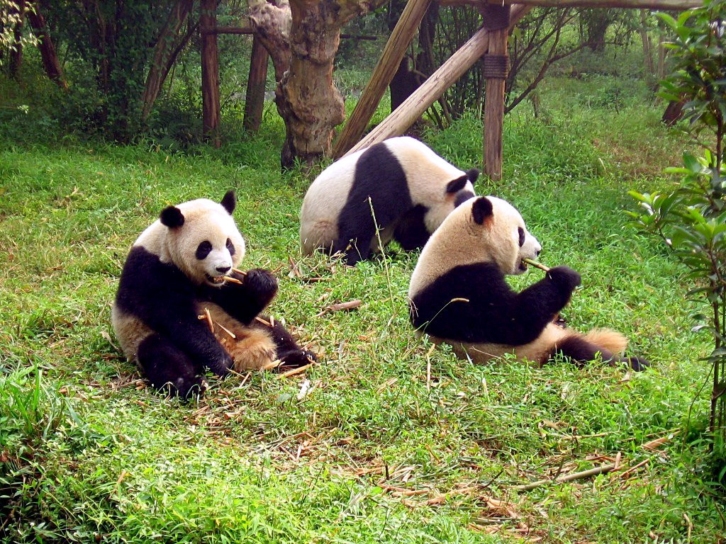
The Sichuan Giant Panda Sanctuaries were inscribed as a UNESCO World Heritage Site in 2006, covering 924,500 hectares across the Qionglai and Jiajin Mountain ranges of Sichuan Province, approximately 70 kilometres west of Chengdu. The inscribed area encompasses 9 nature reserves and 14 nature parks, and supports approximately 30% of the world’s wild giant panda population; the 2021 national census counted 1,864 wild giant pandas across Sichuan, Shaanxi and Gansu provinces, a figure that led the IUCN to reclassify the species from “endangered” to “vulnerable” in September 2021. Wolong National Nature Reserve (200,000 hectares), the largest single component of the inscription, is 130 kilometres west of Chengdu by road via the G350 highway through Yingxiu, a journey of approximately 2 hours.
East and south from Chengdu: an irrigation system and sacred Buddhist mountains 90–180 km, 2–2.5 hours by road or HSR
Mount Qingcheng and the Dujiangyan Irrigation System (UNESCO 2000) is the closest UNESCO-inscribed site to the Sichuan Giant Panda Sanctuaries: Dujiangyan city is approximately 90 kilometres east of Wolong by road through Yingxiu and the Longmen Shan fault zone, a journey of approximately 2 hours. The Dujiangyan dam complex on the Min River was designed by the Qin-dynasty engineer Li Bing around 256 BCE and has irrigated the Chengdu Plain for 2,270 years through a fixed channel-division geometry that requires no sluice gates, pumps or electricity; the Fish Mouth Levee (Yuzui) divides the Min River into inner and outer channels in proportions calibrated so that clean surface water flows to the irrigation network while sediment-laden bottom flow flushes down the outer diversion channel. The Min River originates in the same Qionglai and Minshan mountain ranges that the panda sanctuaries occupy; Li Bing’s 3rd-century BCE engineering works at the river’s exit from the mountains transformed a flood hazard into the irrigation source for the most productive agricultural plain in inland China, a plain that now supports a population of approximately 40 million. Mount Qingcheng (1,260 metres), 15 kilometres southwest of the Dujiangyan dam, is a Taoist sacred site associated with Zhang Daoling (34–156 CE), founder of the Celestial Masters school of Taoism; its forested karst landscape and stone-paved trail network provide a contrast to the panda sanctuary’s wilderness terrain. The Chengdu Research Base of Giant Panda Breeding, within Chengdu city (Chenghua District, 11 kilometres northeast of the city centre), is technically outside the UNESCO inscription boundary but is administratively linked to the Wolong breeding programme and provides the most reliable panda observation opportunity in the region; early morning visits (gates open at 7:30, feeding at approximately 8:00) are recommended before midday inactivity. Mount Emei Scenic Area, including Leshan Giant Buddha Scenic Area (UNESCO 1996), is approximately 180 kilometres south of Wolong by road, or approximately 2 hours by high-speed rail from Chengdu South to Emeishan or Leshan station. Mount Emei (3,099 metres), one of the four sacred Buddhist mountains of China, supports one of the largest concentrations of Buddhist temple architecture in Sichuan; the Baoguo Monastery at the mountain base, the Wannian Monastery mid-mountain and the Golden Summit (Jin Ding) complex at 3,077 metres (the principal summit, served by cable car from Leidongping) represent three distinct altitude zones of Buddhist devotional architecture. The summit hosts populations of Tibetan macaques that approach visitors for food along the cable car approach trail and at the summit viewing areas; the macaques, while entertaining, can be aggressive during food competition and the summit area’s visitor management documents warn against allowing direct feeding. The Leshan Giant Buddha, 33 kilometres from the Emei summit at the confluence of the Dadu, Qingyi and Min rivers, is a Tang-dynasty seated Maitreya figure 71 metres tall carved from a red sandstone cliff between 713 and 803 CE; at completion it was the tallest stone Buddha in the world and retained that status until 2008. The ecological corridor between the panda sanctuary and Mount Emei is not physically direct (the terrain separating Wolong from the Emei/Leshan area includes the Chengdu Plain), but the Buddhist veneration of wildlife in the Emei tradition and the conservation science of the panda sanctuary represent two historically distinct frameworks for the relationship between humans and mountain animal populations in western Sichuan.
Southwest and north: Yunnan parallel rivers and the Tibetan Plateau lakes 300–400 km, 6–8 hours
The Three Parallel Rivers of Yunnan Protected Areas (UNESCO 2003) cover 1,700,000 hectares in northwestern Yunnan Province, approximately 400 kilometres southwest of Wolong by road via the Sichuan–Yunnan highway through Kangding and Litang to Diqing (Shangri-La), a journey of approximately 6–8 hours by road. The inscription protects the upper reaches of three major rivers—the Nu (Salween), the Lancang (Mekong) and the Jinsha (upper Yangtze)—flowing parallel through deep north-south gorges separated by the Gaoligong, Nu and Yunling mountain ranges over a 170-kilometre section where the rivers are as close as 66 kilometres apart; above the gorges, ridgelines reach 6,740 metres at Kawagebo (Meili Snow Mountain), which is the highest peak in Yunnan and an active pilgrimage mountain for Tibetan Buddhist communities. The ecological overlap with the Sichuan Giant Panda Sanctuaries is significant: both inscription areas lie within the same east Himalayan biodiversity hotspot identified by Conservation International as one of the 25 richest and most threatened concentrations of plant life on Earth. The Three Parallel Rivers area contains approximately 7,000 plant species (approximately 25% of China’s total), 173 mammal species and 417 bird species; it is also the principal range of the black snub-nosed monkey (Rhinopithecus bieti, approximately 2,500 individuals), the species most closely related to the Sichuan golden snub-nosed monkey that inhabits the panda sanctuary area. Road conditions on the Sichuan–Yunnan border are subject to seasonal landslide closure (particularly July–September); the Chengdu to Shangri-La flight (approximately 1.5 hours, served by Chengdu Tianfu International Airport) is the reliable alternative and reduces the journey to a single day of transfer. Jiuzhaigou Valley Scenic and Historic Interest Area (UNESCO 1992) and Huanglong Scenic and Historic Interest Area (UNESCO 1992) are located approximately 300 kilometres north of Chengdu by road via the G213 highway through Mao County, approximately 5–8 hours drive (or 1 hour by flight to Jiuzhaigou/Huanglong Airport JZH). Both sites lie in the Minshan mountain range immediately north of the Qionglai range where the panda sanctuaries are located; the Min River that Dujiangyan diverts at the Chengdu Plain edge originates in these mountains and passes through or near both sites. Jiuzhaigou covers 720 square kilometres of lake, waterfall and tufa shoal terrain between 1,996 and 4,764 metres, with 118 named lakes whose calcium-carbonate-coloured water (the same chemistry as Huanglong’s pools) ranges from pale green to deep cobalt depending on depth, sediment load and seasonal temperature. The 2017 Jiuzhaigou earthquake (magnitude 7.0) altered several of the valley’s most photographed lakes and waterfall formations; the site reopened in 2019 with a daily visitor cap of 5,000. The panda sanctuary’s northern boundary in the Jiajin range is approximately 150 kilometres south of the Jiuzhaigou inscription boundary, separated by the Aba Tibetan and Qiang Autonomous Prefecture’s highland grassland terrain; the giant panda does not range into the Jiuzhaigou area, but the red panda (Ailurus fulgens, a separate species) and the Sichuan takin (Budorcas taxicolor tibetana) are present in both the panda sanctuary and the Jiuzhaigou catchment. The Chengdu to Jiuzhaigou/Huanglong flight provides the most efficient access; ground transfer from the airport to Huanglong (40 kilometres) takes approximately 40 minutes and to Jiuzhaigou (88 kilometres) approximately 1.5 hours.
Practical information
The Sichuan Giant Panda Sanctuaries are not a single visitable park but an aggregation of protected areas; the three most accessible visitor entry points are the China Giant Panda Conservation and Research Centre at Shenshuping in Wolong (130 km west of Chengdu, rebuilt after the 2008 earthquake and reopened 2013), the Chengdu Research Base of Giant Panda Breeding in Chenghua District (within Chengdu, open daily from 7:30), and the Bifengxia Giant Panda Base in Ya’an City (approximately 120 kilometres southwest of Chengdu, 2 hours by road). For visitors primarily interested in pandas in a naturalistic setting, Wolong’s Shenshuping centre provides the most expansive environment (500 hectares of semi-wild reserve) but requires a 2-hour road journey and overnight accommodation in Wolong town. For visitors with a single morning available, the Chengdu Research Base is the standard choice: it covers 100 hectares of landscaped habitat within the city and currently holds approximately 50 giant pandas. The best time to visit is October to April, when pandas are most active; during summer heat (June to August), pandas reduce activity significantly during the middle of the day. The Wolong–Dujiangyan route (G350 highway via Yingxiu) passes through the epicentre zone of the 2008 Sichuan earthquake; the Yingxiu earthquake memorial (the partially preserved ruins of the original Xuankou Middle School) is on the route and can be incorporated as a stop. Allow 3–5 days for a Chengdu-based circuit covering the panda base, Wolong, and Dujiangyan/Qingcheng; add 2 days for Leshan/Emei (HSR south from Chengdu); add 3–4 days for Jiuzhaigou/Huanglong (flight or road north). The Three Parallel Rivers in Yunnan require a separate trip of at least 5 days from Chengdu, most efficiently done by flying to Shangri-La (Diqing Airport) and travelling south through the gorge area.
Frequently Asked Questions
Why were giant pandas classified as “vulnerable” rather than “endangered” after the 2021 census and what does the distinction mean for conservation?
The IUCN (International Union for Conservation of Nature) reclassified the giant panda from “endangered” (population below 2,500 mature individuals and declining) to “vulnerable” (population below 10,000 mature individuals) in September 2021 on the basis of the Chinese National Survey of Giant Pandas published that year, which counted 1,864 wild individuals across the species’ range in Sichuan, Shaanxi and Gansu provinces, up from 1,596 in the 2003 survey. The reclassification reflects both the population increase and the expansion of protected area coverage: the number of nature reserves in the panda’s range grew from 13 in 1998 to 67 by 2021, and the Chinese government announced in 2021 the creation of the Sichuan Giant Panda National Park (covering approximately 2.7 million hectares across the Qionglai, Jiajin and other ranges), which will consolidate the existing fragmented reserve system into a continuous corridor. The “vulnerable” designation does not mean the species is out of conservation concern: the IUCN criteria place “vulnerable” below “endangered” and “critically endangered” but above “near threatened” and “least concern,” and the giant panda remains subject to the full international trade prohibitions of CITES Appendix I. The principal remaining threat is habitat fragmentation: the wild population is distributed across 33 isolated subpopulations separated by valleys, roads and agricultural areas, with 18 of those subpopulations containing fewer than 10 individuals—too small for long-term genetic viability without either natural corridor connection or managed transfer. The captive breeding programme (approximately 600 pandas in captivity worldwide as of 2023) provides a genetic insurance population but has had only limited success in returning captive-born pandas to the wild; of the several wild-release attempts conducted at Wolong, one panda (Xiang Xiang) died in 2008 after being attacked by wild pandas, and subsequent releases have required extended semi-wild training at facilities like the Shenshuping centre to reduce this risk.
What is the ecological significance of the Three Parallel Rivers area and how does it connect to the panda sanctuary region?
The Three Parallel Rivers of Yunnan (UNESCO 2003) occupy the geological transition zone where the Eurasian and Indian tectonic plates began colliding approximately 50 million years ago, pushing up the Tibetan Plateau and creating the deeply incised river gorges of northwestern Yunnan. The collision created a north-south orientation of mountain ridges and river valleys that allowed plant and animal species to migrate latitudinally during the Pleistocene ice ages: as glaciers advanced and retreated over the past 2 million years, species that would otherwise have been eliminated in their original range could shift their distribution north or south along the gorge corridors, using the deep valleys as ice-free refugia. This process produced the exceptional species diversity of the Three Parallel Rivers area (approximately 7,000 plant species, compared to approximately 5,000 in all of western Europe) and the extraordinary concentration of endemic species: approximately 20% of China’s plant species in an area covering approximately 0.4% of China’s land surface. The Sichuan Giant Panda Sanctuaries lie at the northern end of the same biodiversity corridor: the Qionglai range where Wolong sits is geologically continuous with the mountain ranges of the Three Parallel Rivers area, separated by approximately 400 kilometres of increasingly high and remote terrain through the Kangding and Litang highlands. The giant panda’s range does not extend into the Three Parallel Rivers area (the species is limited to the bamboo-forested mid-altitude zones of the Qinling and Minshan ranges), but the red panda (Ailurus fulgens) ranges across both inscription areas and serves as a biological link between the two systems. The three rivers themselves—Nu/Salween (draining to Myanmar and the Andaman Sea), Lancang/Mekong (draining to the South China Sea via Laos, Thailand, Cambodia and Vietnam) and Jinsha/Yangtze (draining through central China to the East China Sea)—originate on the Tibetan Plateau and represent three of Asia’s major river systems in a single 170-kilometre corridor.
What happened during the 2008 Sichuan earthquake and how did it affect the Wolong panda breeding programme?
The 2008 Sichuan earthquake (magnitude 7.9, epicentre at Wenchuan on the Longmen Shan fault, 12 May 2008) was the deadliest earthquake to strike China since the 1976 Tangshan earthquake, killing approximately 69,000 people and injuring 374,000 across Sichuan, Gansu and Shaanxi provinces. The epicentre at Yingxiu, in Wenchuan County, is approximately 25 kilometres east of the Wolong Nature Reserve boundary; the maximum intensity zone (Modified Mercalli Scale XI, “extreme”) included both Yingxiu and the Wolong valley. The China Giant Panda Conservation and Research Centre at Hetaoping, in the Wolong valley, suffered severe structural damage: buildings collapsed or were rendered structurally unsafe, enclosure fences were broken or buried by landslides, and one panda enclosure was completely covered by debris. Of the approximately 60 giant pandas resident at the centre at the time of the earthquake, 9 died (3 from direct trauma, 6 from subsequent injuries, stress-related complications or escape into the wild, including one panda named Mao Mao who was never recovered). Emergency evacuation of the surviving pandas to the Chengdu Research Base (22 pandas) and the Ya’an Bifengxia centre (29 pandas) was completed within 2 weeks, using a convoy route rerouted via Luding County after the main G350 highway through Yingxiu was blocked by landslides for an estimated 1 kilometre. The access road to Wolong (rebuilt by 2009) and the Hetaoping area itself were subsequently surveyed for landslide hazard; the new centre at Shenshuping, 2 kilometres upslope, was sited outside the identified hazard zone and designed with reinforced concrete seismic isolation to the current Chinese seismic design standard (Seismic Design Code GB 50011-2010, Zone 8 intensity rating for Sichuan). The earthquake also destroyed approximately 90% of the road network in the Wolong valley and damaged 2,000 hectares of forest habitat, altering the hydrology of several streams that the pandas used as water sources; habitat restoration was included in the reconstruction plan funded under the central government’s post-earthquake reconstruction budget.
Sources
- S1 — UNESCO World Heritage Centre — Sichuan Giant Panda Sanctuaries – Wolong, Mt Siguniang and Jiajin Mountains (Ref. 1213) — https://web.archive.org/web/20230601000000/https://whc.unesco.org/en/list/1213/
- S2 — Sichuan Forestry and Grassland Administration — https://whc.unesco.org/en/list/1213/
- S3 — Seidensticker, John. <em>Riding the Tiger: Tiger Conservation in Human-Dominated Landscapes</em>. Cambridge University Press, 1999. ISBN: 978-0-521-64835-6.
Spotted an error? Write to editorial@culturalheritageonline.com and we correct it the same day.