At a Glance
In the Andean foothills of north-western Argentina, straddling the provinces of San Juan and La Rioja, Ischigualasto Provincial Park and Talampaya National Park together protect the world’s most complete and uninterrupted continental fossil sequence from the Triassic period — the 37-million-year geological interval (245–208 million years ago) when the first dinosaurs evolved. UNESCO inscribed the combined site in 2000 (ref. 966) for its outstanding universal value to palaeontology, geology and our understanding of the origins of dinosaurs and Mesozoic life.
Palaeontological Significance
The Ischigualasto formation contains fossils from the Late Triassic (228–208 Ma), including some of the earliest known dinosaurs on Earth. Eoraptor lunensis — discovered here in 1991 — is one of the most primitive dinosaurs ever found, a small bipedal predator from approximately 231 million years ago. Herrerasaurus ischigualastensis, another Ischigualasto dinosaur, was larger and more derived. The site also yields exceptional specimens of early mammal-like reptiles (therapsids) and the giant amphibians and crurotarsal archosaurs that dominated the Triassic world before dinosaurs. The stratigraphic sequence at Ischigualasto and Talampaya spans the entire Triassic — no other single location on Earth offers such a complete record of this critical period in evolutionary history.
The Valle de la Luna
Ischigualasto’s popular name — Valle de la Luna (Valley of the Moon) — captures the extraordinary visual impact of its landscape: a broad enclosed basin of grey-blue Triassic clay (bentonite) eroded by wind and rain into mushroom-shaped hoodoos, spherical concretions called “bochas” (bowling balls), and dramatic ridges and gullies unlike any other landscape in South America. The clay is so fine and so devoid of vegetation that it gleams silver in sunlight and shifts colour dramatically through the day from grey-blue to terracotta at sunset. The almost complete absence of plants makes fossil discovery straightforward: bones simply erode out of the clay and appear on the surface.
Talampaya
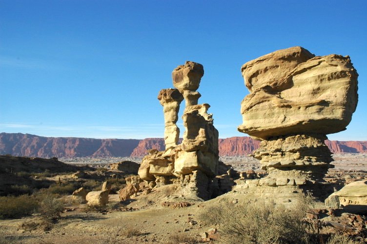
Talampaya National Park, adjacent to the south, protects an older geological sequence: spectacular red Triassic sandstone cliffs and canyons up to 150 metres high, carved by the Talampaya River. The canyon walls bear over 1,500 petroglyphs made by pre-Columbian indigenous peoples (Ciénaga and Aguada cultures, 500–1000 AD), making Talampaya significant for both geological and cultural heritage. The sandstone formations — “La Biblioteca” (The Library), “El Totem”, “La Catedral” — are named for their extraordinary sculptural shapes.
What to See
At Ischigualasto, guided vehicle tours (compulsory; 2–3 hrs) circuit the bochas field, the Valle Pintado ridgelines and the main fossil sites; a small museum at the entrance displays dinosaur casts and geological exhibits. At Talampaya, guided 4WD tours traverse the canyon and approach the petroglyphs; bicycle circuits are available in the less remote sections. Both parks operate sunrise and sunset tours in high season (July–September).
Visiting Conditions
The parks are in an arid high desert (altitude 1,200–1,600 m). Summers (December–February) are extremely hot (40°C+) and prone to flash floods that close access roads. The best visit season is April–October. Both parks require advance booking for guided tours in July–August. Water, sun protection and warm layers for the evening are essential.
Practical Information
Ischigualasto is 330 km north of San Juan city (4 hrs by road). Talampaya is 60 km north of Ischigualasto, off Route 150. The nearest airport is San Juan (SJK); a domestic flight from Buenos Aires takes 1.5 hrs. Car hire is essential for independent access. GPS (Ischigualasto): 29.800° S, 67.830° W.
Nearby
The city of San Juan has a good Museo de Ciencias Naturales with Ischigualasto dinosaur originals. The wine region of the Zonda Valley is 15 km west of San Juan. The Andes border crossing to Chile at Paso Agua Negra (3,900 m) is 240 km west — one of the most dramatic Andean passes in Argentina.
Find it on the map
See this place and what’s around it →📷 Diventa un fotografo di Cultural Heritage Online
Condividi le tue foto dei luoghi: restano pubblicate con la tua firma come autore. Più vengono viste, più ti fai conoscere — e presto un concorso premierà le foto più apprezzate.
Accedi o registrati gratis per aggiungere una foto