Parco Nazionale del Teide (sito naturale): il vulcano-gigante delle Canarie
Si alza a 3.715 metri, la cima più alta della Spagna e dell’Atlantico: il Teide, vulcano e simbolo di Tenerife. Attorno alla sua mole si apre un’immensa caldera lunare di lave colorate, coni e rocce contorte, un paesaggio così alieno da essere usato per simulare la superficie di altri pianeti.
At a glance
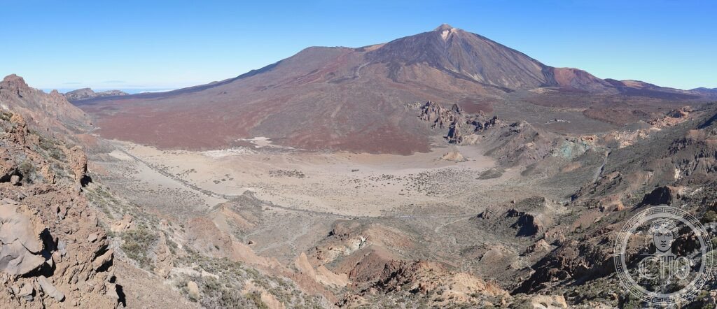
Teide National Park, on the island of Tenerife in the Canaries, surrounds Mount Teide, at 3,715 m the highest peak in Spain and in the whole Atlantic. The great volcano rises from the vast Las Cañadas caldera, a high plain of multicoloured lava flows, cinder cones, twisted rock and craters that forms one of the most spectacular volcanic landscapes on Earth — so otherworldly it is used to test planetary-exploration equipment. It was inscribed by UNESCO in 2007.
Key facts
- UNESCO: World Heritage since 2007 (Teide National Park)
- Highest in Spain: Mount Teide rises to 3,715 m
- Highest in the Atlantic: the tallest peak of any Atlantic island
- Las Cañadas: a vast caldera of coloured lava and cinder cones
- Active volcano: dormant but not extinct
- Otherworldly: the lava fields stand in for other planets in tests
History
Teide is the visible summit of a huge volcano built up over millions of years on the ocean floor, the third-tallest volcanic structure on Earth when measured from its base. Its eruptions shaped Tenerife and were witnessed and recorded in historic times, the last on its flanks in the early 20th century; the volcano is dormant but monitored.
For the indigenous Guanches the peak was sacred, the home of a power that held up the sky, and they feared and revered it. Naturalists and travellers later climbed it to study its rocks, plants and the strange caldera. Protected as a national park in 1954, Teide was inscribed by UNESCO in 2007 for its geology and the beauty of its volcanic landscape.
What you see
A road crosses the Las Cañadas caldera, where lava flows in red, black and ochre, cinder cones and weathered rock formations spread beneath the cone of Teide. A cable car climbs near the summit, from which, on clear days, the view reaches across Tenerife to the neighbouring islands. Endemic plants such as the red tajinaste bloom among the rocks in spring.
The contrast of the snow-streaked peak, the coloured lava desert and the clouds far below is unforgettable.
Practical information
- Park: free access by road; a cable car runs near the summit
- Summit: the final climb to the crater needs a free permit
- Time needed: half a day to a day
- Note: high altitude and strong sun; bring warm clothing and water
Getting there
Teide National Park occupies the centre of Tenerife, in the Canary Islands, Spain, reached by road from the coastal resorts and the cities of Santa Cruz and La Laguna. GPS: 28.272° N, 16.6425° W.
Nearby
- La Laguna — the UNESCO historic town of Tenerife
- La Orotava — a fine old town on the volcano’s slopes
- La Gomera and Garajonay — the neighbouring island and forest
Sources
- UNESCO World Heritage Centre — “Teide National Park” (ref. 1258)
- Organismo Autónomo Parques Nacionales (Spain) — official body
- Encyclopaedia Britannica — Pico de Teide
Find it on the map
See this place and what’s around it →📷 Diventa un fotografo di Cultural Heritage Online
Condividi le tue foto dei luoghi: restano pubblicate con la tua firma come autore. Più vengono viste, più ti fai conoscere — e presto un concorso premierà le foto più apprezzate.
Accedi o registrati gratis per aggiungere una foto