Mont-Saint-Michel (X–XVI sec.): l’abbazia benedettina sull’isola di marea
Sospesa tra cielo, sabbia e acqua, l’abbazia del Mont-Saint-Michel sembra crescere dalla roccia stessa. Per secoli i pellegrini hanno attraversato a piedi la baia dalle maree più potenti d’Europa per raggiungere questo “monte San Michele”, uno dei luoghi sacri più celebri d’Occidente.
At a glance
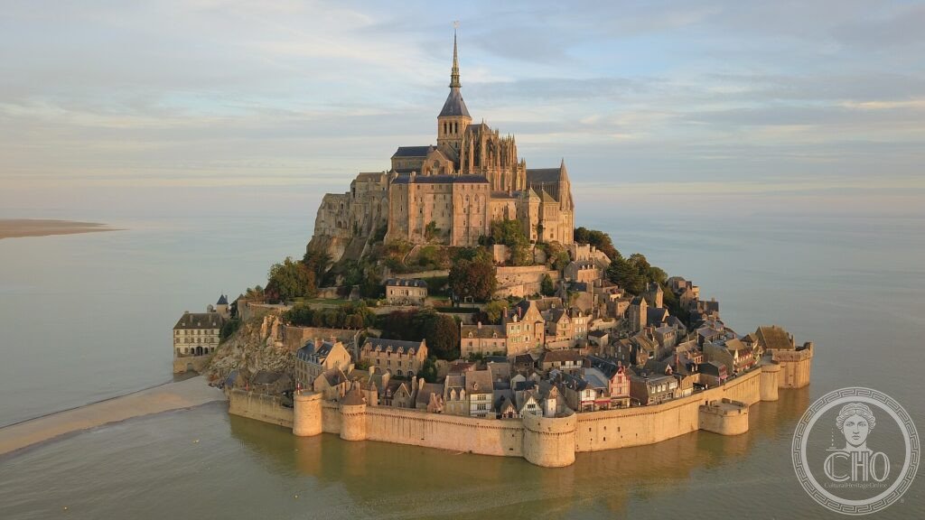
Mont-Saint-Michel is a rocky tidal island in Normandy crowned by a Benedictine abbey, one of the most visited monuments in France. Founded as an oratory in the 8th century and developed from 966 by Benedictine monks, the abbey rose in successive Romanesque and Gothic campaigns into a vertical masterpiece called “La Merveille”. The bay around it has some of the highest tides in continental Europe, historically cutting the mount off from the mainland twice a day. Mont-Saint-Michel and its bay were inscribed by UNESCO in 1979.
Key facts
- UNESCO: World Heritage since 1979 (Mont-Saint-Michel and its Bay)
- Abbey founded: Benedictine community established in 966; oratory on the rock from the 8th century
- La Merveille: the Gothic monastic buildings on the north face, built in the early 13th century
- Tides: the bay has among the largest tidal ranges in Europe (up to about 14 m)
- Pilgrimage: a major medieval destination, the “Mont Saint-Michel au péril de la mer”
- Spire: topped by a gilded statue of Saint Michael, about 156 m above sea level
History
According to tradition, the bishop of Avranches founded an oratory on the rock in 708 after a vision of the Archangel Michael. In 966 Benedictine monks settled there, and over the following centuries the abbey grew through Romanesque and then Gothic building campaigns, culminating in the early 13th century with La Merveille, a stack of monastic halls clinging to the steep north slope.
The mount became one of the great pilgrimage centres of medieval Europe and, protected by its tides, an unconquered fortress during the Hundred Years’ War. After the Revolution the abbey was closed and used as a prison until 1863. Restoration began in the late 19th century, and in 2014 a new bridge restored the island’s tidal character by replacing the old causeway.
What you see
A single street climbs from the fortified gate past medieval houses to the abbey at the summit. The church sits on a platform built over crypts that carry its weight on the narrow rock. La Merveille reveals the monks’ refectory, cloister and scriptorium stacked one above the other, an engineering feat in stone.
From the ramparts the bay stretches out in shifting patterns of sand and water; at the highest tides the sea returns to surround the mount.
Practical information
- Access: a free shuttle or a walk crosses the bridge from the mainland car park
- Abbey: admission charged; the village streets and ramparts are free
- Tides: check tide times; guided bay crossings on foot must go with a licensed guide
- Time needed: half a day, longer to walk the bay
Getting there
Mont-Saint-Michel sits on the border of Normandy and Brittany. The nearest stations are Pontorson (with a bus link) and Rennes or Villedieu-les-Poêles, connected by coach. By car, park on the mainland and take the shuttle. GPS: 48.6361° N, 1.5115° W.
Nearby
- Saint-Malo — the corsair walled city on the Breton coast, about 50 km west
- Bayeux — home of the famous medieval embroidery, about 120 km north-east
- Normandy D-Day beaches — the 1944 landing sites along the coast
Sources
- UNESCO World Heritage Centre — “Mont-Saint-Michel and its Bay” (ref. 80)
- Centre des monuments nationaux — Abbaye du Mont-Saint-Michel, official site
- Encyclopaedia Britannica — Mont-Saint-Michel
Find it on the map
See this place and what’s around it →📷 Diventa un fotografo di Cultural Heritage Online
Condividi le tue foto dei luoghi: restano pubblicate con la tua firma come autore. Più vengono viste, più ti fai conoscere — e presto un concorso premierà le foto più apprezzate.
Accedi o registrati gratis per aggiungere una foto