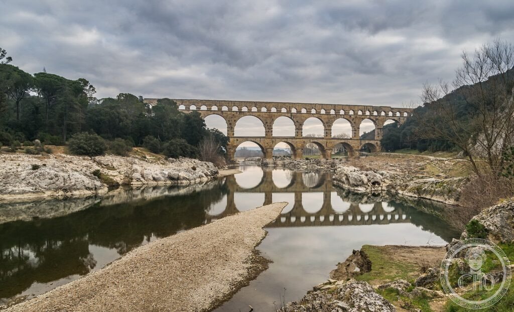
Pont du Gard (I sec. d.C.): l’acquedotto romano a tre ordini di arcate che portava l’acqua a Nîmes
Quasi cinquanta metri d’altezza, tre ordini di arcate, cinquantamila tonnellate di pietra montate senza una goccia di malta: il Pont du Gard è il punto in cui l’acquedotto romano di Nîmes scavalca il Gardon. Diciannove secoli dopo, è ancora lì — e l’intera condotta scendeva di appena dodici metri in cinquanta chilometri.
At a glance
The Pont du Gard is the most spectacular surviving stretch of the Roman aqueduct that carried water some 50 km from a spring near Uzès to the city of Nîmes (ancient Nemausus). Built in the middle of the 1st century AD, the bridge spans the river Gardon in three superimposed tiers of arches and stands almost 49 m high — the tallest of all surviving Roman aqueduct bridges. It was raised in dressed limestone fitted without mortar, a feat of engineering and proportion that has made it, since antiquity, a symbol of Roman building genius. UNESCO inscribed it in 1985.
Key facts
- UNESCO: World Heritage since 1985
- Function: the showpiece of a ~50 km aqueduct supplying Roman Nîmes from the Eure spring near Uzès, built in the mid-1st century AD
- Dimensions: about 49 m high and some 275 m long, in three tiers — 6 arches below, 11 in the middle, 35 small arches carrying the water channel on top
- Construction: some 50,000 tonnes of shelly limestone, cut and laid without mortar; projecting stones once supported the scaffolding
- Precision: over its whole 50 km the aqueduct fell only about 12 m — an average gradient of roughly 25 cm per km — delivering thousands of cubic metres of water a day
- Afterlife: used as a toll road bridge in the Middle Ages, which helped preserve it; restored from the 18th century onward
History
Nemausus — modern Nîmes — was a flourishing Roman colony that outgrew its springs, and in the 1st century AD its engineers built an aqueduct to bring fresh water from the hills near Uzès. The route had to cross the gorge of the Gardon, and there the builders raised the Pont du Gard, stacking three rows of arches to carry the covered water channel at the necessary height. The whole conduit was a masterpiece of surveying: its tiny, almost imperceptible gradient kept the water flowing by gravity across the entire distance.
The aqueduct supplied Nîmes for centuries before silting up and falling out of use after the Roman period. The bridge survived because later ages found it useful as a river crossing; tolls were charged to maintain it, and from the 18th century it was deliberately preserved and restored as a monument of antiquity — Rousseau among the travellers who stood beneath it in awe.
What you see
From the visitor area on either bank the bridge appears between the trees in its full three-tier height, the honey-coloured stone reflected in the green Gardon below. You can walk across the lowest tier (a road bridge added in the 18th century alongside the Roman arches) and look up at the massive piers, the projecting blocks that carried the scaffolding, and the still-visible mason’s marks. On guided visits it is possible to reach the top tier and look into the specus, the covered channel down which the water ran.
A museum and interpretation centre tell the story of the aqueduct and Roman hydraulics, and footpaths follow stretches of the buried conduit through the surrounding garrigue.
Practical information
- Visiting: the site (museum, paths, river area) is ticketed per vehicle/visitor; the bridge itself is freely seen from the banks
- Activities: swimming and canoeing on the Gardon below in summer; the garrigue trails follow the ancient aqueduct
- Time needed: 1.5–2 hours, more with the museum and river
Getting there
The Pont du Gard is between Nîmes and Avignon, near Remoulins and Vers-Pont-du-Gard (Gard). By car from Nîmes (25 km) or Avignon (25 km); bus services run from both cities in summer. GPS: 43.9471° N, 4.5356° E.
Nearby
- Nîmes — the Roman city with its amphitheatre (Arènes) and the Maison Carrée (itself UNESCO, 2023)
- Uzès — the elegant ducal town near the aqueduct’s source
- Avignon — the Palais des Papes, 25 km east
Sources
- UNESCO World Heritage Centre — “Pont du Gard (Roman Aqueduct)” (ref. 344)
- Site du Pont du Gard — official (pontdugard.fr)
- Encyclopaedia Britannica — Pont du Gard
Find it on the map
See this place and what’s around it →📷 Diventa un fotografo di Cultural Heritage Online
Condividi le tue foto dei luoghi: restano pubblicate con la tua firma come autore. Più vengono viste, più ti fai conoscere — e presto un concorso premierà le foto più apprezzate.
Accedi o registrati gratis per aggiungere una foto