Portici di Bologna — 40 km di Arcate Storiche
The most extensive system of arcaded walkways in the world — 62 km in the historic centre alone, 40 km of which are inscribed by UNESCO — built from the twelfth century onward as extensions of private houses projecting over the public street, creating a continuous covered route through an entire city: Bologna’s portici are not an ornamental addition to its streets but the structure of its public life, the reason the city’s intellectual and commercial activity concentrated on foot rather than in carriages, and the most direct possible demonstration that architecture can constitute the social fabric of a place.
At a glance
Bologna has more arcaded walkways per capita — and in absolute terms — than any other city in the world. The historic centre alone contains approximately 62 km of portici; the UNESCO inscription (2021, ref. 1650) covers 12 sections totalling approximately 40 km, chosen to represent the full chronological and typological range of the building type: medieval wooden porticoes (Via dell’Archiginnasio), Renaissance brick arcades (Piazza Maggiore and surroundings), Baroque corridors (Via dell’Indipendenza), the covered route to the Santuario di San Luca (3.8 km, the longest arcaded route in the world), and the nineteenth-century glass-and-iron galleries (Galleria Cavour).
The portico in Bologna is not a decorative element but a structural fact: from the twelfth century, the city’s medieval municipal statutes required that new constructions at street level include a covered walkway at a minimum height of 7 Bolognese feet (approximately 2.25 metres) for public passage. The upper storeys of the building extended outward over the street, supported by wooden or brick columns, creating a continuous covered lane at ground level. The medieval portici were wooden; from the fourteenth century, brick construction became mandatory for fire-resistance; from the fifteenth, stone columns and brick vaults became the standard.
Key facts
- Total extent: ~62 km in the historic centre of Bologna; ~40 km in the UNESCO inscription
- UNESCO inscription: 2021, ref. 1650 — “The Porticoes of Bologna,” 12 inscribed sections
- Earliest portici: XII century; originally wooden; mandatory by municipal statute from early medieval period
- Portico di San Luca: 3.796 km; 666 arches; longest arcaded route in the world; built 1674–1793 to connect the city to the Santuario di San Luca on the hill of the Guardia
- Piazza Maggiore arcades: XIV–XV century; the defining visual element of Bologna’s civic centre
- GPS (Piazza Maggiore): 44.4939, 11.3438 — Google Maps
History
The portico is an ancient form — Vitruvius describes the Greek stoa, the Roman forum colonnade, the medieval communal loggia — but Bologna developed it into something unique: a mandatory urban infrastructure imposed by law on every property owner, creating a continuous covered network rather than the occasional covered square or colonnade. The earliest municipal statutes requiring portici date from the late eleventh and early twelfth centuries; by the thirteenth century, when Bologna had become one of the largest cities in Europe (population c. 50,000–70,000, with 10,000 students at the University of Bologna, the oldest university in the Western world founded 1088), the portico system was already the defining feature of the city’s street life.
The University of Bologna’s presence drove a specific type of demand: students and faculty needed to move between buildings in all weathers, carry books and instruments, and conduct the kind of informal intellectual exchange that happens between people walking and talking. The portici made Bologna’s streets suitable for precisely this activity — covered, level, continuous, connecting the university buildings, the market squares, the churches, the palaces, and the gates of the city in a single walkable network. The Archiginnasio (the university’s main building from 1562) was built with a double arcade of particularly fine proportions; the Via dell’Archiginnasio portico is the canonical image of Bologna for all its visitors.
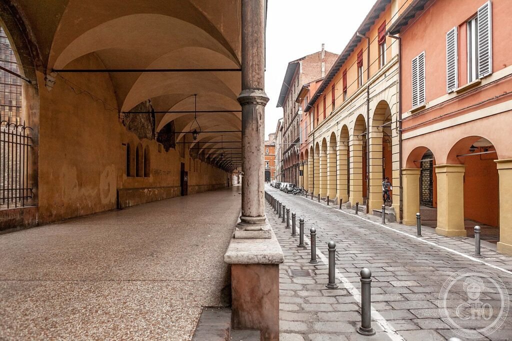
What you see
The portici are most legible from the outside: standing in the middle of any major street and looking along the covered lane, you see the rhythm of arches receding to a vanishing point — in brick, in stone, in iron-and-glass depending on the period. In via Saragozza, the arches are high and wide, in Quattrocento brick, with the Via San Luca portico beginning at the Porta Saragozza and continuing visibly up the hill. In via Zamboni (the university quarter), the arches are lower and more varied, some wooden-beamed, some vaulted, with the department buildings of the university behind them. Piazza Maggiore itself is defined by the arcades of the Palazzo dei Banchi and the Palazzo del Podestà — you walk under them and the piazza opens on your left.
The Portico di San Luca (3.8 km, 666 arches, built 1674–1793): the longest arcaded route in the world ascends the Guardia hill from Porta Saragozza to the Santuario di San Luca. Walking the full route in one direction takes approximately 45 minutes; the gradient is steady; the views from the upper section over the Po plain are panoramic. The santuario at the top contains a Byzantine icon of the Virgin attributed to St Luke.
Gallery
Practical information
- The portici are public space: free and always open (they are the streets themselves).
- Portico di San Luca: free; allow 2 hours for the full round trip on foot (7.6 km). Bus 20 from Piazza Maggiore if you prefer one-way.
- Guided walks: the Bologna tourist office runs regular “Portici” themed walks (~€15) in Italian and English — recommended for understanding the typological variety.
- Best time: rain — when the portici show their function most clearly, and the rest of the city is quiet.
- Via dell’Archiginnasio: the canonical portico route; 10-minute walk from Piazza Maggiore.
Getting there
Bologna is the railway hub of northern Italy: high-speed trains from Milan (1h), Florence (35 minutes), Rome (2h10), Venice (1h35). The high-speed station is Bologna Centrale, 20 minutes on foot from Piazza Maggiore or 10 minutes by bus. By car: A1 (Milan–Rome) and A14 (Venice–Taranto) both pass through Bologna; the historic centre is ZTL restricted — park outside the Viali (ring road) and walk or use public transport. Bologna Guglielmo Marconi airport: 10 km from the centre, connected by the Aerobus shuttle (20 minutes, €6) or taxi (20 minutes, ~€25).
Nearby
- Piazza Maggiore e Basilica di San Petronio — the civic and religious centre of medieval Bologna; San Petronio (begun 1390) was intended to be the largest church in the world (it was left unfinished); the Meridiana (sundial) on the floor is the longest in the world
- Archiginnasio — the university’s main building (1562); the Anatomical Theatre (1637, entirely in wood and carved figures) is the most remarkable university interior in Italy
- Due Torri (Torre degli Asinelli e Torre Garisenda) — the defining image of medieval Bologna; the Asinelli (97m, begun 1109) can be climbed; the Garisenda (48m, leaning) cannot; both are visible from most of the city centre
Sources
- UNESCO: whc.unesco.org/en/list/1650
- Wikipedia EN: Porticoes of Bologna
- Grandi, Renzo (ed.): I portici di Bologna, Bologna, 2002
- Touring Club Italiano: Bologna, TCI, 2021 (updated UNESCO edition)
Find it on the map
See this place and what’s around it →📷 Diventa un fotografo di Cultural Heritage Online
Condividi le tue foto dei luoghi: restano pubblicate con la tua firma come autore. Più vengono viste, più ti fai conoscere — e presto un concorso premierà le foto più apprezzate.
Accedi o registrati gratis per aggiungere una foto