
Su Nuraxi di Barumini
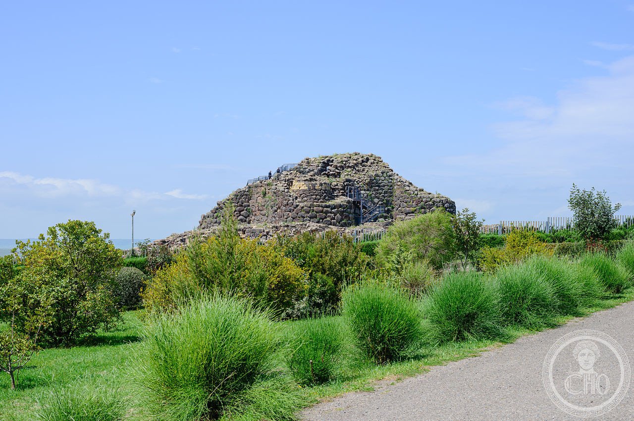
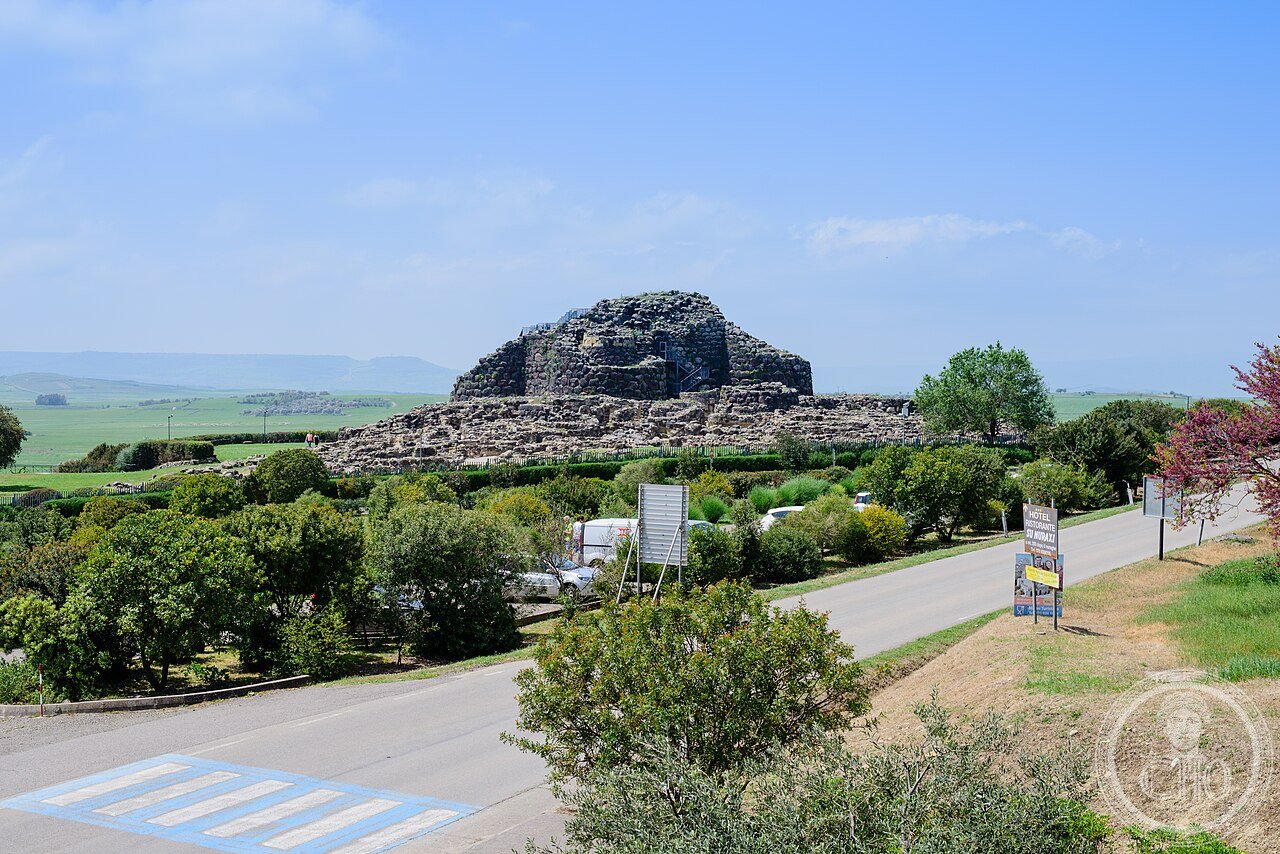
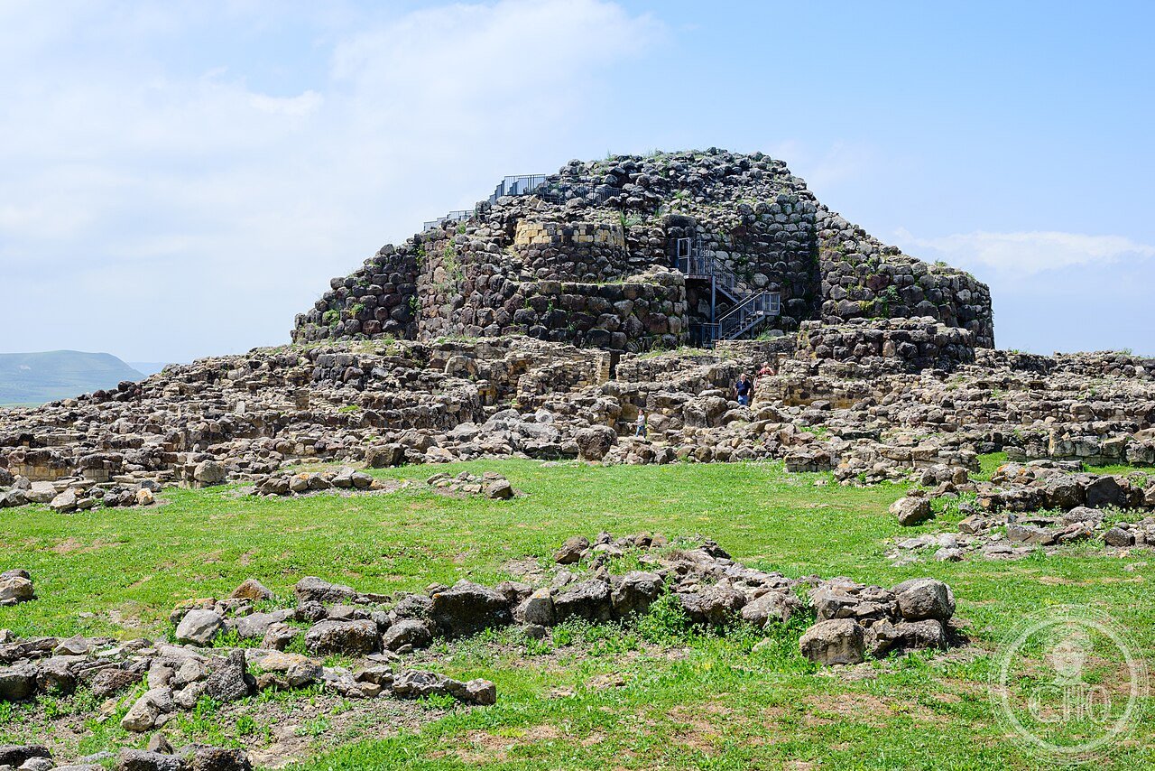
Su Nuraxi di Barumini (UNESCO 1997) is the most important Bronze Age monument in the Mediterranean outside the Aegean — a dry-stone nuraghe tower (c.1500 BCE) surrounded by a 7th-century BCE village of 200 circular huts that represents the full sequence of Nuragic civilization (1800–238 BCE), whose 7,000 surviving towers are the most dense concentration of prehistoric monuments in Europe.
At a glance
Su Nuraxi di Barumini (the most precisely Nuraxi zone Barumini Sardegna Italy 39.7069 N 8.9927 E UNESCO WHS 1997 reference 833: the nuraghe (the name: “Su Nuraxi” in Sardinian means “the nuraghe” — the local word for the Bronze Age stone towers; the Sardinian nuraghi (plural) number approximately 7,000 surviving examples on the island, giving Sardinia the highest density of prehistoric monument types in Europe; the specific form: the typical nuraghe is a circular truncated cone built from dry stone blocks (no mortar; the weight of the stone holds the structure); the interior contains a tholos-vaulted chamber (a corbelled stone vault in which each course of stones overlaps inward until the opening closes); the larger nuraghi (the “polylobe” type) add secondary towers linked by walls around the primary central tower; Su Nuraxi is a polylobe nuraghe of the most elaborate type: the central tower (c.1500 BCE) + 3 secondary towers (c.1200 BCE) + 1 additional secondary tower (c.800 BCE) + a village of approximately 200 huts + an outer wall with 5 bastions; the Giovanni Lilliu excavation (1949–1956 CE: the Italian archaeologist Giovanni Lilliu (1914–2012 CE; “the father of Nuragic archaeology”) conducted the first systematic excavation of Su Nuraxi; the excavation revealed the village layout under accumulated debris of 2 meters in some areas; the finds (now in the Cagliari Archaeological Museum) include bronze figurines (bronzetti), ceramics, metal tools, and the evidence of the continuous use of the site from c.1500 BCE to the Punic period (c.5th century BCE)); the Nuragic civilization (c.1800–238 BCE: the Nuragic culture (named after the nuraghi) occupied Sardinia from approximately 1800 BCE (Late Bronze Age) to 238 BCE (Roman conquest); the 3 phases of nuraghe construction: (1) the proto-nuraghe (simple rectangular chambers, c.1800–1600 BCE); (2) the tholos nuraghe (circular plan, corbelled vault, c.1600–1200 BCE: the majority of the 7,000 surviving nuraghi); (3) the polylobe nuraghe (central tower + secondary towers, c.1200–800 BCE: the most elaborate and the most debated typologically — the secondary towers may have been clan residences or defensive bastions or both)).
Key facts
- The tholos vault of the Su Nuraxi central tower and what it tells us about Sardinian Bronze Age architectural knowledge: the vault structure (the specific construction: the tholos vault is formed by placing horizontal courses of stone so that each course extends slightly inward beyond the course below until the opening narrows to a point at the top; this is the corbelled vault — not a true arch (a true arch uses wedge-shaped voussoir stones and transfers load laterally; the corbelled vault transfers load downward through the wall mass); the advantage: a corbelled vault can be built without centering (without a temporary wooden formwork inside); the disadvantage: the corbelled vault can only span a limited width (the diameter of the Su Nuraxi ground-floor chamber is 5.5 m; this is the maximum practical span for a dry-stone corbelled vault); the specific height (the original central tower height of approximately 18.6 m (now 14.9 m) is estimated from the diameter of the base and the known constructional geometry; the base diameter is 13 m; the taper angle is 8–10 degrees; the mathematics gives the original height range)); the bronze figurines (bronzetti; small bronze votive figures (5–20 cm) cast in the lost-wax (cire-perdue) method; the most characteristic Nuragic artwork; subjects: warriors, archers, boxers, mother-goddess, animals, ships, nuraghi in miniature; the ships in miniature are evidence that the Nuragic people were seafarers; they have been found in Etruscan and Mycenaean contexts outside Sardinia — evidence of Bronze Age Mediterranean trade connections)
- GPS (Su Nuraxi): 39.7069° N, 8.9927° E
History
From the Bronze Age tower to the Carthaginian domination to the Roman conquest to Lilliu’s discovery (the most precisely Nuraxi zone history: the construction phases (c.1500 BCE: the central tholos nuraghe (the first construction campaign); c.1200 BCE: the 3 secondary towers and the connecting walls (the “bastion” construction); c.1000–800 BCE: the village (approximately 200 huts in a spiral layout radiating outward from the central tower)); the Carthaginian period (c.540–238 BCE: the Carthaginians (the Phoenician colony of Carthage in modern Tunisia) dominated the coastal and lowland areas of Sardinia from approximately 540 BCE; the Nuragic population retreated to the island interior; the village at Su Nuraxi shows evidence of Carthaginian-period reuse: Punic-style ceramics and bronze objects in the later occupation layers); the Roman conquest (238 BCE: Rome took Sardinia from Carthage without a battle (the Carthaginians surrendered the island as part of the First Punic War settlement; the precise circumstances are disputed); the island was the first Roman province outside the Italian peninsula; the Nuragic population continued in the interior as “the Sardi Pelliti” (the Sardinians in animal skins, as the Roman sources describe them, meaning the non-Romanized mountain people)); the archaeological recovery (1949–1956 CE: Giovanni Lilliu’s 8-year excavation at Su Nuraxi; the site had been known (the tower was visible above ground) but had not been systematically excavated; Lilliu found the village covered under 2 m of accumulated debris; the bronzetti collection (now in the Cagliari Museo Archeologico Nazionale; approximately 3,000 figurines from Nuragic sanctuaries across Sardinia)); 1997 CE UNESCO inscription reference 833.
What you see
The central tower, the 3 secondary towers, the village huts, and the Museo Civico di Barumini (the most precisely Nuraxi zone visit (1.5 hours on site + Museo)): the site (the entrance to the site is the Barumini tourist office; open daily 9 AM–5 PM (winter) / 9 AM–7 PM (summer); admission €12 (guided tour only; no self-guided entry; tours in Italian, English, and French at scheduled times: 9 AM, 10:30 AM, 12 PM, 2 PM, 3:30 PM, 5 PM (summer); the guided tour (45 min): the 3 bastion towers (the visitor can enter the chamber of the NE secondary tower; the tholos vault is visible from inside; the corbelling technique is clearly visible in the construction); the central tower (the ground-floor chamber: the tholos vault at 5.5 m spans the maximum corbelling diameter; the staircase in the wall thickness leads to the now-partially-collapsed first floor); the village huts (circular plan, dry stone walls, the entrance door jamb stones clearly visible; the hut floors are rock-cut or packed earth; the hearth position in the center of each hut)); the Museo Civico “Giovanni Lilliu” (Via San Giovanni, Barumini; open daily; €5; combined ticket with Su Nuraxi €15; the bronzetti originals (6 figurines); the ceramics and metalwork from the site; the reconstruction models of the tower construction sequence)).
Practical information
- Getting to Barumini from Cagliari and combining with the Marmilla archaeological landscape: from Cagliari (the Sardinian capital; 55 km north of Barumini): ARST regional bus (45 min; from Cagliari Piazza Matteotti; 3 buses per day (morning and afternoon); check arst.sardegna.it for current timetable); or car (SS197; 50 min; the road passes through the Marmilla plateau — the landscape of low hills with basalt outcrops is visible on the drive); the Marmilla extension (the area around Barumini contains approximately 80 nuraghi within 20 km; the most notable: the Nuraghe Is Paras at Isili (40 km north: the largest free-standing tholos chamber in Sardinia: 13.7 m high and 11 m wide interior — the widest corbelled vault in the world; closed for restoration 2024–2026)); the photography (the best light at Su Nuraxi is morning (9–10 AM) when the sun is from the east and the texture of the basalt blocks is visible; the late afternoon (5–7 PM in summer) is the second best (the site is backlit but the warm light on the west faces of the towers is dramatic); midday is the worst (flat overhead light))
Getting there
ARST bus from Cagliari Piazza Matteotti (45 min, 3/day). Car: SS197, 50 min. Guided tours only, €12. Open 9am-7pm (summer). GPS: 39.7069, 8.9927.
Nearby
- Cagliari — 55 km south (the Sardinian capital; Museo Archeologico Nazionale (the largest Nuragic bronzetti collection in the world: 3,000 figurines from all phases of Nuragic civilization); the Castello quarter (medieval Pisan walls; the Cathedral; the Roman amphitheatre (2nd century CE; carved into the rock of the Cagliari hill))
- Gennargentu e Golfo di Orosei — 80 km northeast (the highest mountain range in Sardinia; the Gorropu Gorge (the deepest gorge in the Mediterranean — 500 m deep, 5–8 m wide); the Cala Luna and Cala Goloritzé beaches (boat access only); the nuraghe Arrubiu at Orroli (5 secondary towers — the most complex polylobe nuraghe in Sardinia))
Gallery
Sources
- Wikipedia, Su Nuraxi di Barumini; Nuraghe; Nuragic civilization; Giovanni Lilliu, accessed June 2026
- UNESCO, Su Nuraxi di Barumini, WHS reference 833, inscribed 1997
- Lilliu, Giovanni. La Civiltà dei Sardi dal Neolitico all’étà dei nuraghi. Torino: ERI, 1967 (the foundational monograph of Nuragic archaeology)
Find it on the map
See this place and what’s around it →📷 Diventa un fotografo di Cultural Heritage Online
Condividi le tue foto dei luoghi: restano pubblicate con la tua firma come autore. Più vengono viste, più ti fai conoscere — e presto un concorso premierà le foto più apprezzate.
Accedi o registrati gratis per aggiungere una foto