Portici di Bologna
The porticoes of Bologna (UNESCO WHS 2021) constitute the most extensive system of covered public walkways in the world — 38 surviving kilometres of continuously vaulted arcades that have linked every point in the city centre for 900 years, allowing the entire urban population to move through the city in any weather without exposure; and the single Portico di San Luca (3.796 km long; 666 arches) is by itself the longest continuous porticoed street in the world.
At a glance
Portici di Bologna (the most precisely PorticiBologna single Bologna Emilia-Romagna Italy 44.4985 N 11.3426 E UNESCO WHS 2021 reference 1650 the portico system (the etymology: “portico” derives from the Latin porticus, a covered colonnade; the Italian use of the term for the specifically Bolognese urban covered passageway is distinct from the ancient Roman architectural type; the Bolognese portici are a vernacular building type evolved from the 11th century practice of extending the upper floor of a timber-framed building over the public street to gain floor area; the extension was regulated by municipal law from 1288 CE onwards, which required all new portico construction to be built at a minimum height of 2.66m (7 feet Bolognese measure — a height sufficient for a mounted soldier to pass) and at a standardized column spacing; these regulations created the visual uniformity of the Bologna street despite the portico bays being built by different private owners over 9 centuries): 62 km of portico were built in Bologna between the 11th and 20th centuries; 38 km survive; the UNESCO inscription covers 12 separate groups of portico rather than all 38 km; the 12 groups were selected to represent different types (the medieval wooden-column type (rare surviving examples in Via Musei); the 12th–13th century stone-column type (the main type, via dell’Indipendenza, Strada Maggiore); the 14th–15th century brick-pier type; the colonnaded arcades of Piazza Maggiore; the Portico di San Luca) and different social functions (the university district; the market area; the pilgrimage route).
Key facts
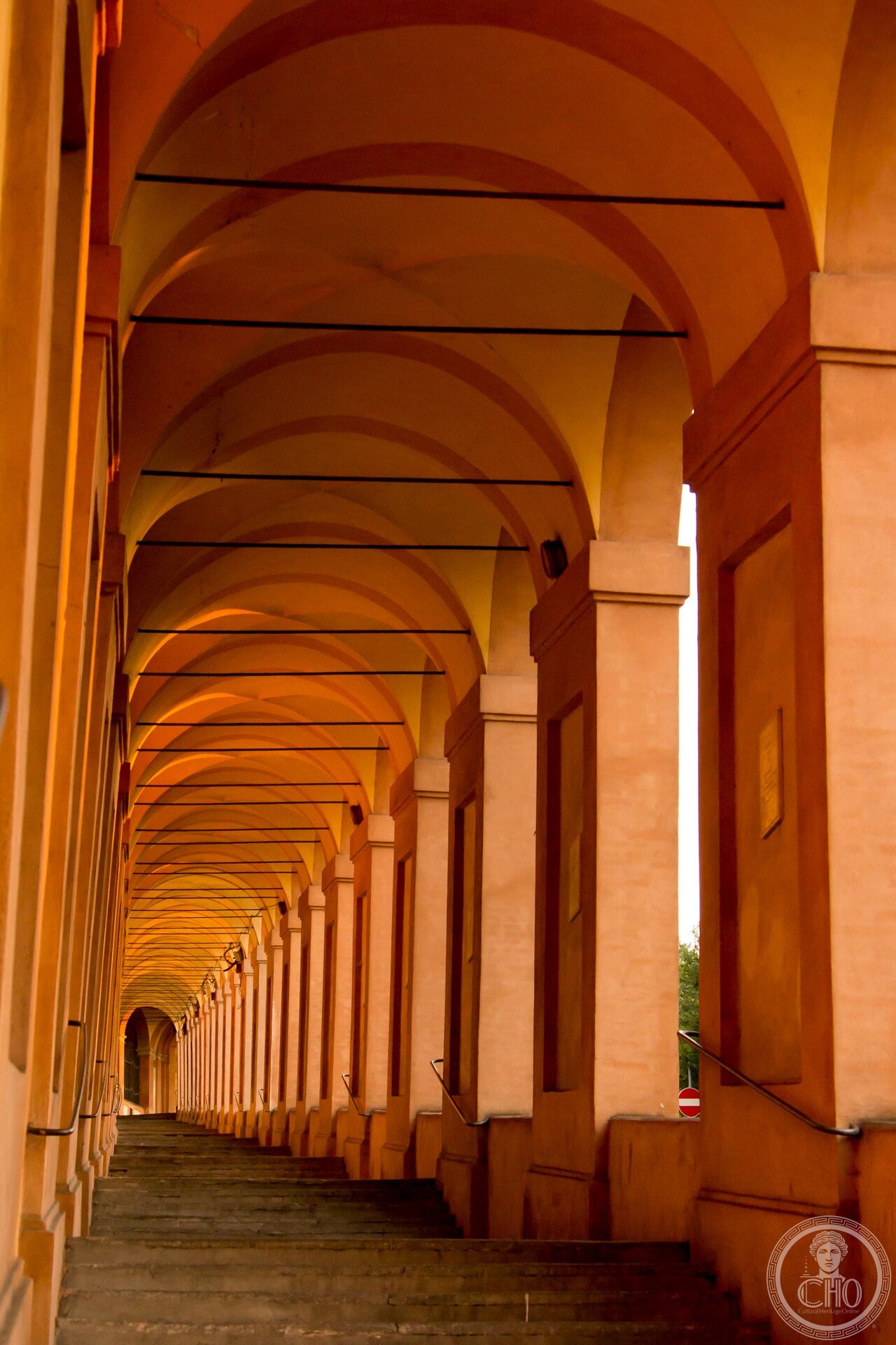
- The Portico di San Luca and why its 666 arches are the most counted-per-walk architectural detail in Italy: the Portico di San Luca (3.796 km; 666 arches; rise from the Porta Saragozza city gate at 56m elevation to the Sanctuary of the Madonna di San Luca at 289m elevation; the longest uninterrupted porticoed pathway in the world) was built between 1674 and 1739 CE; the specific construction organization: the portico was divided into sections financed by individual guilds, noble families, and confraternities (religious brothrohoods) — each section sponsor paid for the arches bearing their family arms or guild symbols; the result is that each arch patron is documented by a cartouche at the crown of the arch (the documentation is still complete: you can read who paid for each of the 666 arches in the archival records held at the Archiginnasio library); the 666 arches figure: the number 666 is documented in multiple sources as the intended count (the Biblical resonance of the number of the Beast was noticed and debated in the 18th century; the scholarly consensus is that 666 was the result of measurement-driven planning rather than symbolic choice; but the Bolognesi have historically given the number a mythological interpretation); the physical experience: walking the full 3.8 km is a 45-minute walk at moderate pace; the portico is used by Bolognesi as a training ground for the Procession of the Madonna (the icon of the Madonna di San Luca is carried in procession from the Sanctuary to the Cathedral of San Pietro every spring — the Ascension Thursday procession; the icon is the most important religious object in Bologna; the procession has been continuous since 1433 CE)
- GPS Piazza Maggiore: 44.4940° N, 11.3428° E
- GPS Porta Saragozza (start San Luca): 44.4952° N, 11.3224° E
History
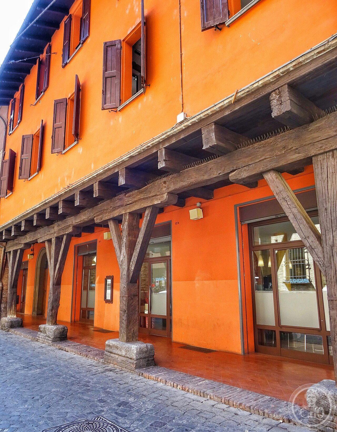
From medieval timber extensions to regulated stonework to UNESCO recognition (the most precisely PorticiBologna single 11th CE century origins: the earliest portico building in Bologna dates to c.1040–1060 CE (the precise dating is contested; the Bolognese municipal chronicles (Cronaca A; early 13th century compilation) refer to portico construction as an established practice before 1100 CE); the construction method: the upper floor of a timber-framed house was extended over the public street on wooden beams supported by wooden posts; the extension gained the building owner approximately 1.5–2m of additional floor area per bay at minimum cost; the posts occupied public pavement but did not block the street; the practice spread rapidly because it was immediately imitated and because Bologna was the site of the oldest university in Europe (the University of Bologna; founded 1088 CE; the student population required intensive housing construction and the timber-portico extension was the fastest way to add student accommodation above street-level commercial space) 1162 CE the first municipal regulation: the Consulate of Bologna issued ordinances governing portico construction standards — minimum height, mandatory public access; 1288 CE the definitive statute: height standardized at 2.66m Bolognese; the material transition: the 13th century saw the gradual replacement of timber columns with stone; the stone column type became standard after the 1272 CE fire that destroyed significant timber construction; 1674–1739 CE Portico di San Luca built; 1800–1900 CE the demolition phase: significant portico demolition occurred in the 19th and early 20th centuries when Bologna modernized; 24 km of the original 62 km was demolished; the surviving 38 km is primarily in the historic centre 2021 CE UNESCO inscription reference 1650 (the most recent Italian UNESCO inscription; the file was submitted in 2019 CE).
What you see
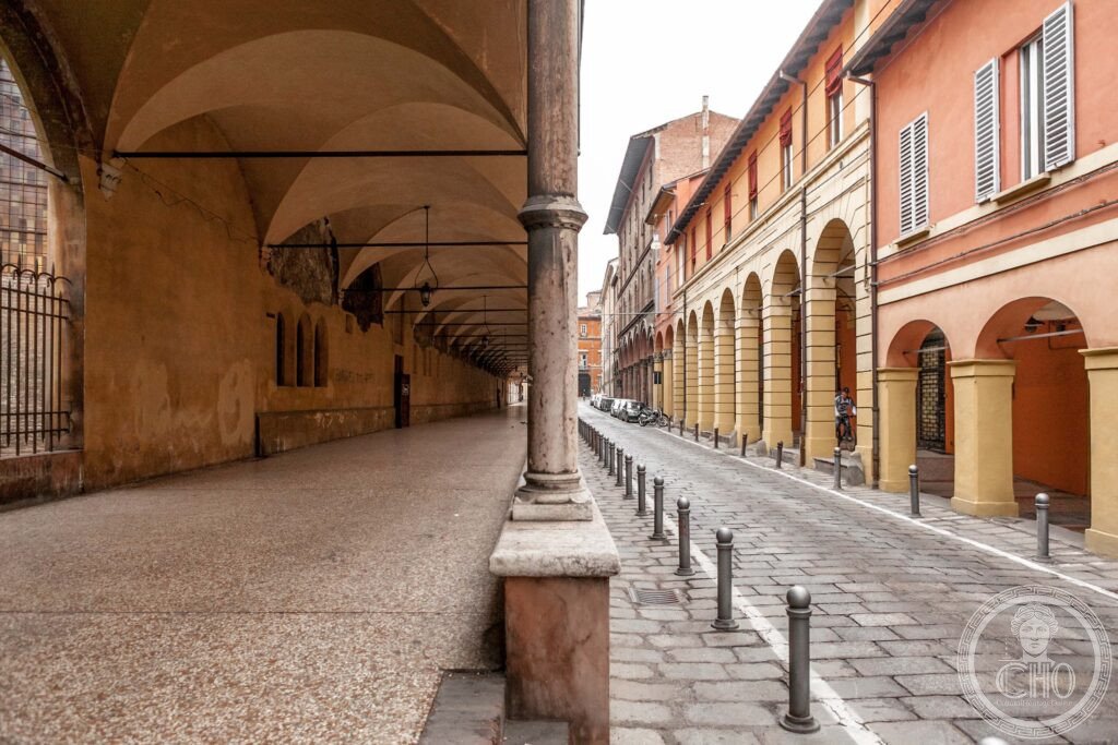
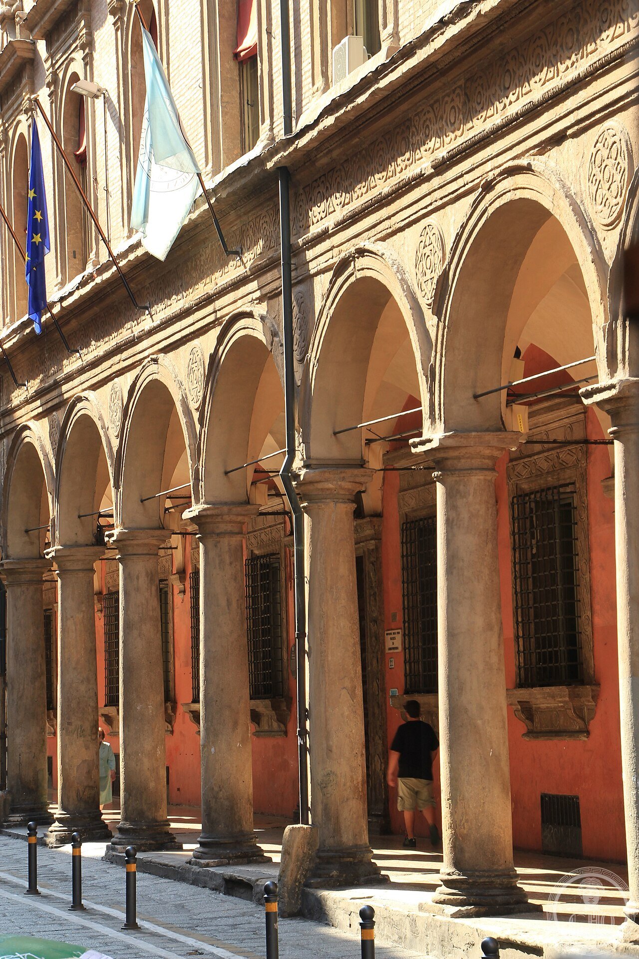
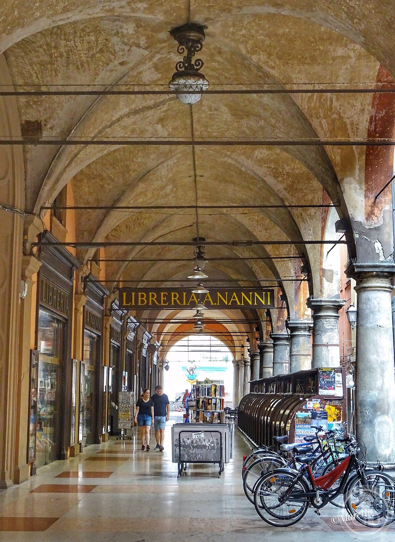
The varieties of Bolognese portico and the circuits that show them (the most precisely PorticiBologna single 4 main types: Type 1 wooden columns (the rarest surviving type; best example: Via Musei 8-14; 3 surviving bays of 12th century timber posts with stone capitals; the only complete surviving example of the earliest portico type; the posts are 23cm square section — very slender relative to the load; the stone capitals are carved with grotesque faces and foliage in the Lombard-Romanesque style); Type 2 stone columns (the most common type; the Via dell’Indipendenza circuit; tall round columns in red Verona marble (the standard Bologna portico column material is either the local sandstone or the imported Verona red marble; the red marble columns are the luxury version used on the most important commercial streets; the stone column portico bays are typically 3–5m wide and 5–7m deep, covering the full width of the sidewalk and the outer portion of the building ground floor); Type 3 brick piers (14th–16th century; the Strada Maggiore and Via Santo Stefano; the heavier pier replaces the column because the upper floors were now in brick rather than timber; the Piazza di Porta Ravegnana — the Two Towers — has the densest brick-pier portico fragment in Bologna); Type 4 colonnaded piazza arcades (Piazza Maggiore; the Palazzo del Podestà (1201 CE; rebuilt 1483–1494 CE by Aristotele Fioravanti — the same architect who built the Dormition Cathedral in Moscow for Ivan III; the portico of the Palazzo del Podestà on all 4 sides is the most architecturally significant portico in Piazza Maggiore; the massive single columns at the corner pilasters are 5m tall — the largest single column shafts in any Bologna portico); the 2-hour circuit: Porta Saragozza → Portico di San Luca (first 5–10 arches and back, or full 45-min walk to the Sanctuary and return) → Piazza Maggiore → Via dell’Indipendenza → Via Musei (wooden columns; 10 min) → Via Rizzoli → Due Torri).
Practical information
- Walking the porticoes and the food that goes with it: the Bolognese portico circuit is self-guided (no tickets; the porticoes are public space at all hours; the UNESCO heritage site has no entry fee by definition); the recommended sequence: start at Piazza Maggiore (the Basilica di San Petronio (begun 1390 CE; the largest church in the world measured in volume at the time of its construction — still the 5th largest; the facade was never completed; the interior is a late-Gothic nave of unusual austerity broken by chapels; the Chapel of the Magi (north aisle) has a fresco cycle by Giovanni da Modena (1410 CE) that was cited by Dante scholars as a source for the Inferno (the specific painting: a map of Hell showing Muhammad being tortured — it generated an attempted attack by Islamist activists in 2002 CE and now has permanent police protection)) → Piazza del Nettuno (the Neptune fountain (1566 CE; Giambologna; the most famous sculptural fountain in Italy after the Trevi; the standard guidebook description of the main figure’s provocative gesture is apocryphal but persistent) → Via dell’Indipendenza (north portico walk to the train station; 15 min under cover; the best rainy-day walk in Bologna) → return via Via Manzoni to the University district (the Archiginnasio; 1563 CE; the original university building; now the municipal library with the anatomical theatre (1637 CE; a wooden anatomy lecture room with full-body carved figure displays; destroyed in 1944 WWII bombing and restored 1948–1950 CE using original fragments); the Palazzo Poggi (now the university museum complex)) → Piazzola del Nettuno lunch at one of the central salumerie (the Tamburini delicatessen (Via Caprarie 1; open since 1932 CE) is the standard introduction to Bolognese food (mortadella per etti; tortellini in brodo; tagliatelle al ragù — the ragù is legally trademarked: the official recipe was deposited with the Bologna Chamber of Commerce in 1982 CE by the Accademia Italiana della Cucina; it calls for beef + pork + pancetta + wine + milk + tomato in specific proportions; no cream))
Getting there
Bologna Centrale: 2h10min from Milan, 2h15min from Florence (Alta Velocità). From the station: 20 min walk via Via dell’Indipendenza (the porticoed main street). Portico di San Luca starts at Porta Saragozza (30 min walk or bus 20 from Piazza Maggiore). San Luca Sanctuary open 7:30-12:30, 14:30-19:00 daily. GPS Piazza Maggiore: 44.4940, 11.3428.
Nearby
- Ferrara — 50 km east (UNESCO WHS 1995; the Este Renaissance city; the Addizione Erculea (1492–1505 CE; Biagio Rossetti; the planned Renaissance expansion of Ferrara — the only surviving complete medieval city with a planned Renaissance extension; the straight Corso Ercole d’Este was the widest and most regular street in Renaissance Italy at the time of its construction); the Castello Estense (1385 CE; moated; the Este court prison where Parisina Malatesta and Ugo d’Este were executed for adultery in 1425 CE — the incident cited by Byron in his poem “Parisina”))
- Ravenna — 75 km east (UNESCO WHS 1996; the 6 early Christian mosaics; the Mausoleum of Galla Placidia (430 CE; the oldest surviving late antique dome mosaic in the world; the ceiling starfield mosaic (1,800 individual gold-background tesserae stars) is the most photographed ceiling in Ravenna))
Gallery
Sources
- Wikipedia, Porticoes of Bologna; Portico di San Luca; University of Bologna; Piazza Maggiore, Bologna, accessed June 2026
- UNESCO, Porticoes of Bologna, WHS reference 1650, inscribed 2021
- Hubert, Hans W. “I portici di Bologna.” In L’architettura a Bologna dal Medioevo al Novecento. Bologna: Istituto per i Beni Culturali della Regione Emilia-Romagna, 2001
Find it on the map
See this place and what’s around it →📷 Diventa un fotografo di Cultural Heritage Online
Condividi le tue foto dei luoghi: restano pubblicate con la tua firma come autore. Più vengono viste, più ti fai conoscere — e presto un concorso premierà le foto più apprezzate.
Accedi o registrati gratis per aggiungere una foto