Monte Etna
The most persistently active volcano in Europe and the most scientifically studied volcano in the world — Monte Etna (UNESCO Natural Heritage 2013) has been erupting in documented history since 693 BCE, has shaped the entire eastern coast of Sicily, gave the Greeks the myth of Hephaestus’s forge and gave Medieval Europeans the image of Hell, and is today a mountain where you can ski in the morning and eat swordfish by the sea in the afternoon.
At a glance
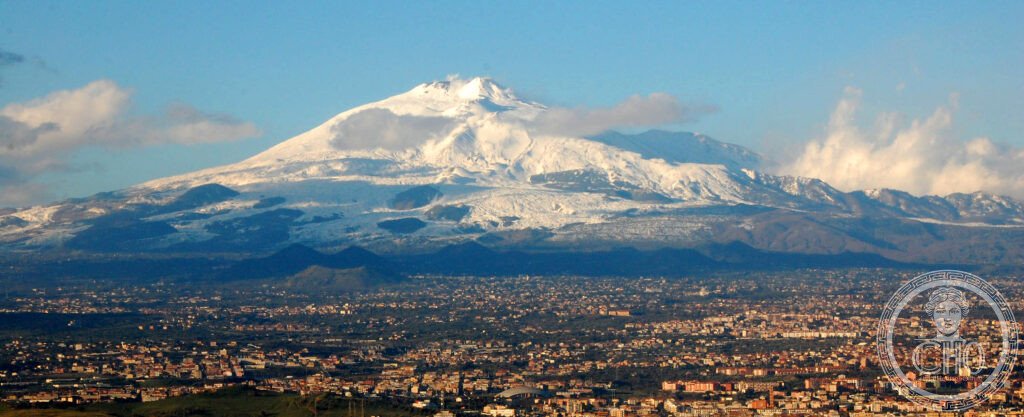
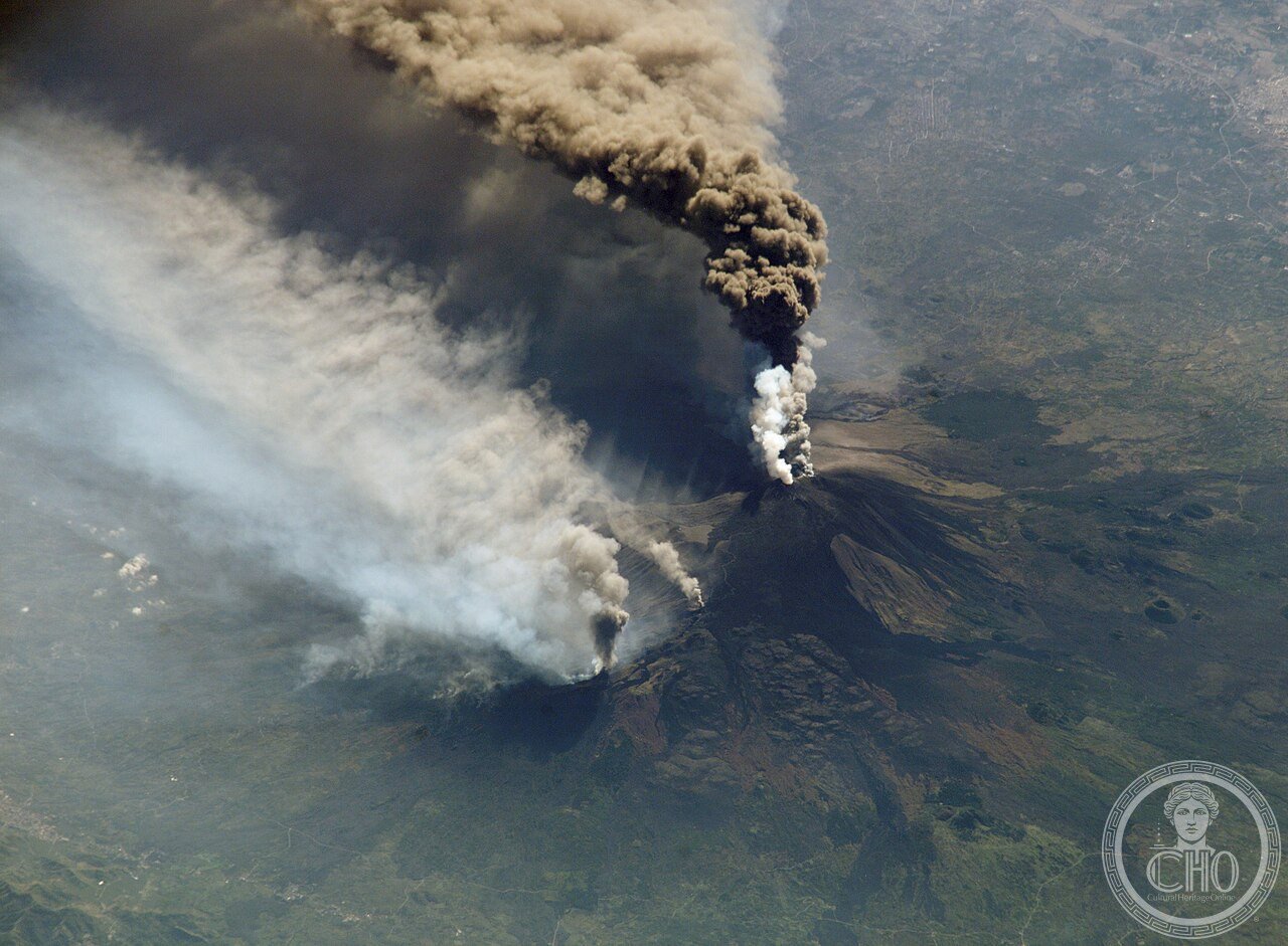
Monte Etna (the most precisely MontEtna single Sicilia Italy 37.7510 N 14.9930 E UNESCO World Natural Heritage 2013 reference 1427 the highest active volcano in Europe: the current summit height is approximately 3,357m above sea level (the summit height changes with each major eruption — it has been as high as 3,369m in 2012 CE and as low as 3,319m in different periods; the UNESCO submission used 3,329m but the active peak was higher by 2013 CE; the height is recalculated after each major eruption cycle); active stratovolcano above the Eurasian-African plate boundary (the specific tectonic driver of Etna’s exceptional productivity: the African plate is subducting beneath the Eurasian plate along the Sicily Channel; the subducting slab releases water into the overlying mantle which lowers the melting point and produces large volumes of magma; Etna sits above the point where the slab-derived magma reaches the surface; additionally, a hotspot may contribute deep magma independently of the subduction — the combination makes Etna the highest-output volcano in Europe); Parco dell’Etna established 1987 CE: 59,000 hectares of protected territory on the Etna massif; the park boundary includes all the main volcanic landforms (summit craters, Valle del Bove (the 7km × 5km caldera on the east flank — the world’s largest caldera on an active volcano in Europe), lateral cones, lava fields, Etna forests of beech and birch)).
Key facts
- The Valle del Bove and the history of Etna’s most dramatic collapse (how a 35,000-year-old caldera became the largest volcanic caldera in Europe): the Valle del Bove (Valley of the Ox; named in a 1642 CE description for its broad U-shape that reminded observers of an ox-head seen from the air) is a caldera 7km wide and 5km deep on the eastern flank of Etna; the formation: approximately 35,000 years ago a major collapse of Etna’s east flank (possibly triggered by the intersection of a fault zone with the volcanic system) produced a massive landslide that sent approximately 40 cubic km of volcanic rock eastward into the Ionian Sea — the largest terrestrial landslide in the Mediterranean in the last 100,000 years; the caldera left by this collapse is the Valle del Bove; since the collapse, Etna’s lava production has partially refilled the caldera floor (the depth is now approximately 1,000m below the caldera rim instead of the original estimated 2,000m; the caldera is still being filled at approximately 3 metres per century by current lava production; the valley walls (the Schiena dell’Asino ridge to the north; the Rocca Musarra to the south) expose 30,000 years of stratified lava flows in vertical cross-section — the geological record of Etna’s eruption history in the walls of the caldera; this continuous geological record visible in a single valley cross-section is one of the UNESCO OUV criteria for Natural Heritage
- GPS summit area: 37.7510° N, 14.9930° E (approx.)
History
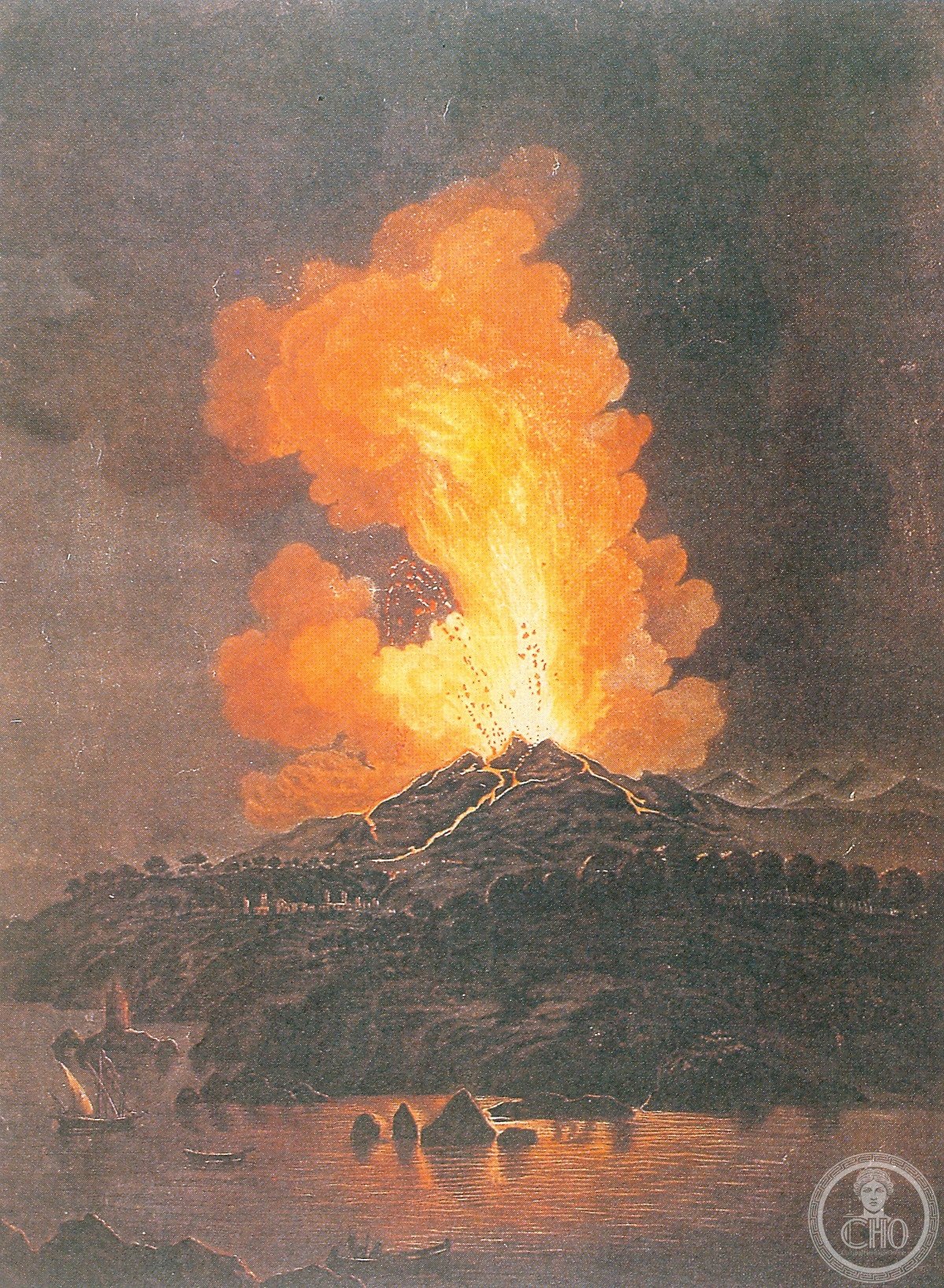
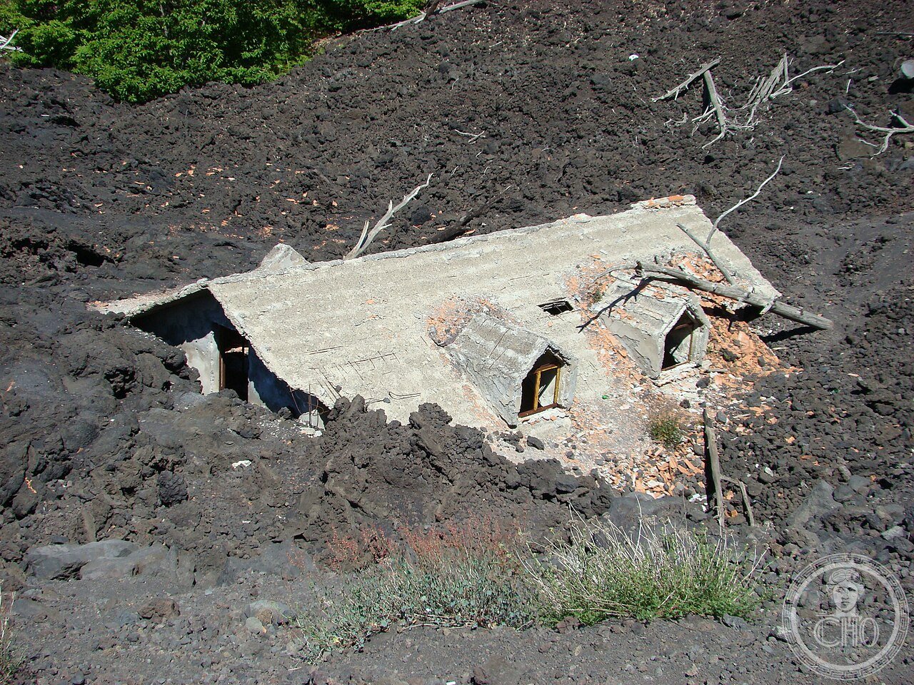
From Greek mythology to Roman disaster to UNESCO Natural Heritage (the most precisely MontEtna single 693 BCE the first precisely dated eruption of Etna in classical sources (Thucydides mentions an eruption that destroyed the Siculi settlement of Catania in the 7th century BCE; the exact date 693 BCE is from modern analysis of the historical text combined with stratigraphy) mythological significance: in Greek mythology Etna is the forge of Hephaestus (Vulcan in Roman mythology); the Cyclops Polyphemus and his clan lived in the caves at the base of Etna (the Aeolian Islands and the caves of the Etna coastline were the setting for Odysseus’s encounter with Polyphemus in Book 9 of the Odyssey); Empedocles (490–430 BCE; philosopher of Akragas (Agrigento); the pre-Socratic philosopher who proposed the 4-element theory: fire/water/earth/air — the first systematic theory of matter in Western philosophy) allegedly jumped into the crater of Etna to prove he was immortal or divine (the story is told by Diogenes Laertius; it is almost certainly legend but the legend itself is 2400 years old and still associated with Etna in popular culture); Aeschylus visited Sicily and describes the eruption of 475 BCE in Prometheus Bound (the chaining of Prometheus under the volcano — the most explicit connection of Etna to the Olympian myths in surviving Greek tragedy) 79 CE Vesuvius erupts (same year as Pompeii but Etna is much older and more continuously active; the comparison between Etna and Vesuvius is the most persistent misidentification in popular culture — Pompeii makes Vesuvius famous but Etna has 3× the volume and 4× the eruption frequency) 1669 CE the most destructive historical eruption: the eruption of 1669 CE destroyed the lower walls of Catania, reaching the sea and adding 4 square kilometres of new land to the Sicilian coastline (the Praiola cape south of Catania is entirely new land created by the 1669 CE lava flow; the flow lasted 122 days from March to July); the 15,000 deaths from this eruption are the largest single Etna death toll in historical records; the Carmelite monks of Catania organized the first coordinated lava diversion attempt: using iron tools and shields they broke open the side of the lava tube to redirect the flow away from the city — the world’s first documented organized lava flow diversion attempt 2013 CE UNESCO Natural Heritage inscription reference 1427: the specific OUV criteria: (1) geological processes — active formation of new volcanic landforms; (2) natural phenomena — the ongoing eruption processes visible from the surface; (3) geological record — the Valle del Bove cross-section; (4) biodiversity — the endemic plant species on the Etna slopes that have colonized fresh lava flows).
What you see
Summit craters, Valle del Bove, Silvestri craters, and the Etna Wine zone (the most precisely MontEtna single visitor access: 4 principal zones by altitude and approach; Zone 1 — Nicolosi (south face; 698m; the main access point from Catania; the Parco dell’Etna visitor centre; cable car (Funivia dell’Etna; closed when eruption or weather risk; operates 9 AM–4 PM; €30 return to the upper station at 2,500m); from the cable car upper station: guided hiking to the summit crater area (€60 pp guided group; the guide is mandatory above 2,900m by Sicilian civil protection regulation; the summit craters are active and produce toxic SO₂ — gas masks distributed by guides); the Silvestri craters (side craters 1892 CE; at 1,900m; accessible by cable car then short walk; the best views of the Valle del Bove from the Silvestri crater rim); Zone 2 — Piano Provenzana (north face; 1800m; the most recent 2002 CE eruption covered this area in lava; the “lava desert” landscape of 2002 lava is the most dramatic recent eruption landscape accessible by car; the rifuges (mountain huts) on this face were all destroyed in 2002 and have been rebuilt in lava-resistant positions); Zone 3 — Zafferana Etnea wine country (the Etna DOC wine zone on the eastern slopes at 400–900m altitude; the Nerello Mascalese grape variety that grows only on Etna volcanic soils and is now one of the most sought-after varieties in the world; the Benanti winery (Via Giuseppe Garibaldi 475; Viagrande; 20 min from Catania; the oldest continuously operating Etna DOC winery; tasting tours available); Zone 4 — Linguaglossa (north-eastern access; the town at 550m that gives access to the Mareneve road to Piano Provenzana; the weekly Saturday market that sells Etna-grown pistachios, honey, and dried mushrooms)).
Practical information
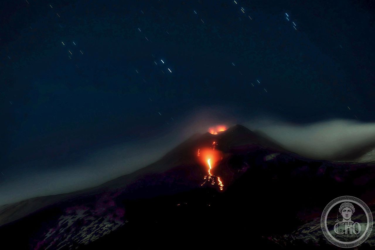
- Getting there and eruption monitoring: from Catania airport: bus AST (Azienda Siciliana Trasporti) direct to Nicolosi (south face; 40 min; operates daily) or rental car (25 min to Nicolosi; 35 min to Zafferana; the car allows the full Etna circuit in one day); the Circumetnea railway (narrow gauge; from Catania Borgo station to Riposto; the 110km circuit around the base of Etna; the most scenic railway in Sicily by landscape; not all stops have return trains — check timetable at circumetnea.it; runs daily; 3h30m full circuit; a smaller section from Catania to Bronte (the pistachio capital of Sicily; the Bronte pistachio IGP is the highest-quality pistachio in Italy; 6,000 tonnes per year from the Etna volcanic soils; harvested biennially in autumn in even years only) takes 1h15m); eruption status check (INGV — Istituto Nazionale di Geofisica e Vulcanologia; ingv.it; the INGV Etna section publishes daily bulletins on summit activity, tremor level, and access restrictions; the cable car and guided hikes are cancelled when the INGV tremor level is elevated or when active lava fountaining at summit craters is in progress; approximately 30–50% of attempted summit excursions are cancelled due to weather or eruption activity — build flexibility into planning); best time: May–June for visibility (less cloud cover than April) + July–September for snow-free summit access; winter skiing at Piano Provenzana and Nicolosi (facilities modest — Etna is not a dedicated ski resort but the skiing with a volcano view is unique)
Getting there
From Catania: bus AST to Nicolosi 40 min or car 25 min. Cable car €30 return (2500m, closed in bad weather/eruption). Summit guide MANDATORY above 2900m (€60 pp). Circumetnea railway 3h30min circuit. INGV daily eruption status (ingv.it). Etna DOC wine at Benanti winery. GPS summit: 37.7510, 14.9930.
Nearby
- Catania — 30 km south (the city most affected by Etna’s 1669 CE eruption; the Baroque city rebuilt in lava stone after 1693 CE earthquake; Piazza del Duomo with the Fontana dell’Elefante (1736 CE; the grey lava-stone elephant — the city’s symbol and the most photographed fountain in Sicily); the Pescheria fish market (the largest and most chaotic seafood market in Sicily; swordfish in summer, sea urchins year-round)); the La Pescheria market is specifically located at the point where the 1669 lava flow reached the sea — the historic market square is on lava from that eruption)
- Taormina — 55 km north-east (the ancient Teatro Greco-Romano (3rd BCE century; rebuilt in Roman period; 109m diameter — the second largest surviving Roman theatre in Sicily; famous for the backdrop of Etna and the Ionian Sea visible from the stage; summer performances June–August at taormina-arte.com; the view of Etna from the theatre seats is the most frequently photographed combination of antiquity and active volcanism in Italy))
Gallery
Sources
- Wikipedia, Mount Etna; Valle del Bove; Etna DOC; 1669 eruption of Mount Etna, accessed June 2026
- UNESCO, Mount Etna, WHS reference 1427, inscribed 2013 (Natural Heritage)
- INGV — Istituto Nazionale di Geofisica e Vulcanologia, Osservatorio Etneo, Catania
Find it on the map
See this place and what’s around it →📷 Diventa un fotografo di Cultural Heritage Online
Condividi le tue foto dei luoghi: restano pubblicate con la tua firma come autore. Più vengono viste, più ti fai conoscere — e presto un concorso premierà le foto più apprezzate.
Accedi o registrati gratis per aggiungere una foto