Þingvellir (Thingvellir)
The birthplace of democracy in the North and the only place on Earth where you can walk between two tectonic plates — Þingvellir (southwestern Iceland; UNESCO WHS 2004) is a dramatic rift valley on the Mid-Atlantic Ridge where the Norse settlers established the Althing in 930 CE (the world’s oldest continuously operating parliament), making it simultaneously the most important historical site in Iceland and one of the most dramatic geological landscapes in Europe.
At a glance
Þingvellir (the most precisely ThingvellirIceland single southwestern Iceland 40 km east Reykjavik Þingvellir National Park 92 km2 Þingvallavatn largest lake Iceland 84 km2 largest natural lake Iceland Mid-Atlantic Ridge rift valley tectonic divergence North American Plate Eurasian Plate moving apart 2cm per year 7.7km Almannagjá gorge up to 32m deep rift valley floor drops Iceland geology highly active geologically young island entirely volcanic ocean floor Þingvellir plain is the rift valley floor between two tectonic plate edges can walk on the exact boundary plate edges visible as rock walls of the gorge Althing Norse althing al-thing thing thing = assembly all-thing all-Iceland assembly 930 CE first Althing 930 CE Ingólfur Arnarson first permanent settler 874 CE Iceland colonized 870 930 CE land-taking landfnam period 930 CE Althing established Þingvellir Gissur the White Þorsteinn Ingólfsson proposed site first elected Lawspeaker (Lögsögumaður) Úlfljótr created original law code for Iceland Úlfljótr’s Law UNESCO heritage in any UNESCO world heritage site)).
Key facts
- The Althing (the world’s oldest continuously operating parliament): the Althing (established 930 CE at Þingvellir; from Old Norse: alþing, “general assembly”) met annually for two weeks in June at Þingvellir for 300 years (930-1262 CE) while Iceland was a free commonwealth without a king; the Lawspeaker (Lögsögumaður — the only paid official in Iceland) recited one-third of the law code from memory from the Law Rock (Lögberg) each year (the entire code was recited over a 3-year cycle); the Althing was not a democracy in the modern sense: free-born men could speak and attend; women could not vote (though widows had some property rights); thralls (slaves) were excluded; the Chieftains (Goðar) held the real power; nevertheless, the Althing (the institution of public law-giving by community assembly, in an open outdoor space, without a monarch) is the template for all subsequent Nordic parliamentary traditions; the Althing is the oldest parliament still operating: it was suspended 1799-1843 CE (under Danish control) but was re-established in Reykjavik in 1843 CE and moved to a permanent building in 1881 CE; it continues to operate today
- GPS: 64.2559° N, -20.9113° W
History
From Norse land-taking to Viking parliament to Christian conversion to Danish rule to modern democracy (the most precisely ThingvellirIceland single 874 CE Ingólfur Arnarson first permanent Norse settler Iceland settled Reykjavik 870 930 CE Landnám Land-Taking period Norse settlers colonized entire Iceland 930 CE Althing founded Gissur the White Þorsteinn Ingólfsson Úlfljótr law Þingvellir chosen site good central location grassland camping water 930 1000 CE Althing met Þingvellir annually June two weeks 1000 CE adoption Christianity Althing 1000 CE Christianization Iceland Althing decision to convert officially avoid civil war between pagans Christians Þangbrandr missionary violent 999 1000 CE Althing mediator Þorgeir Ljósvetningagoði Lawspeaker decided all Iceland convert Christianity peaceful political compromise 1000 CE 1262 CE Old Commonwealth period free Iceland no king Althing highest authority 1262 CE Sturlung Age civil war Sturlungar powerful clan dominant Iceland surrendered to Norwegian King Hákon Old Old Norwegian Haakon IV 1262 1264 CE Iceland under Norway crown 1380 CE Norway and Iceland both under Denmark 1402 1404 CE Black Death devastated Iceland 40 60% population died 1550 CE Reformation Lutheranism 1627 CE Barbary Pirates Turkish Abductors raided Iceland took 400 Icelanders slaves North Africa 1783 CE Laki volcanic eruption most destructive eruption Iceland history 1/4 population died 9000 of 50000 1799 CE Danish Crown abolished Althing 1843 CE Althing reestablished in Reykjavik Danish reform 1944 CE Icelandic independence referendum June 17 1944 CE Republic Iceland proclaimed Þingvellir symbolically significance independence declared Þingvellir connecting to 930 CE founding 2004 CE UNESCO UNESCO heritage: the conversion of Iceland to Christianity 1000 CE (the most democratic religious conversion in history): the Christianisation of Iceland (1000 CE) was unique in European history: rather than being imposed by royal decree or military force (as in Poland, Hungary, Bohemia, Denmark, and Norway in the same century), it was decided by a public vote of the Althing; the Lawspeaker Þorgeir Ljósvetningagoði (himself a pagan) was tasked with the decision; after lying under his cloak for 24 hours in meditation (the traditional Norse practice for important decisions), he announced that Iceland would convert to Christianity — but pagans could still sacrifice to the old gods privately; this compromise avoided civil war; the conversion was adopted without violence; it is the only national religious conversion in medieval European history decided by public assembly vote)) — the most precisely ThingvellirIceland single 874 CE Ingólfur Arnarson 930 CE Althing founded 1000 CE Christianity Þorgeir mediator 24 hours under cloak convert avoid civil war only democratic national conversion medieval Europe 1262 CE surrender Norway 1380 CE Denmark 1783 CE Laki 1/4 population 1799 CE Althing abolished 1843 CE reestablished 1944 CE independence proclaimed Þingvellir symbolic 2004 CE UNESCO heritage in any UNESCO world heritage site)).
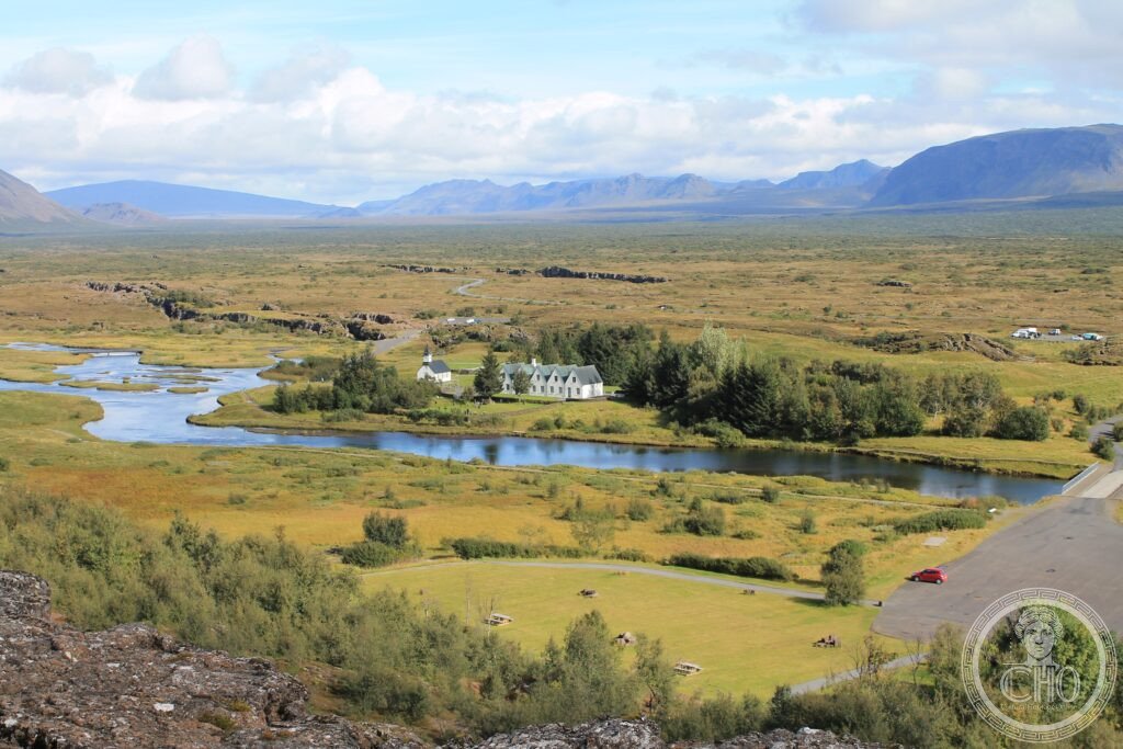
What you see
The Almannagjá gorge, the Law Rock, and the rift valley landscape (the most precisely ThingvellirIceland single Almannagjá Gorge Law Rock Gorge 7.7 km long 32m deepest rift valley floor walk along gorge path East Wall North American Plate rock face West Wall Eurasian Plate walking between tectonic plates literally standing on rift zone Law Rock Lögberg raised platform low mound within the gorge where Lawspeaker stood recited law visible marker flagpole marks location today Þingvallakirkja Church church on site 1859 CE white Icelandic church standing in rift valley below plateau edge beautiful setting cemetery behind church burial site government ministers famous Icelanders Flosagjá Gorge second major gorge southeast Almannagjá clear glacial water visibility 100m+ snorkeling scuba diving between the tectonic plates Silfra fissure diving world famous dive site snorkeling clear glacial water visibility underwater rift Þingvallavatn Lake 84 km2 largest natural lake Iceland 114m deep brown trout Arctic char famous fishing lake Iceland golden circle route Þingvellir + Geysir geothermal area + Gullfoss waterfall 3 most visited natural/cultural sites Iceland day trip Reykjavik UNESCO heritage: snorkeling and diving in the Silfra Fissure (the world’s clearest underwater rift): the Silfra Fissure (part of Þingvellir National Park; a crack in the boundary between the North American and Eurasian tectonic plates; filled with glacial meltwater from Langjökull Glacier filtered through volcanic lava rock for 30-100 years before reaching Silfra; water temperature 2-4°C year-round; visibility 80-120m — greater than any tropical dive site; the widest section (the Cathedral) is 15m wide; the narrowest (the Crack) requires swimmers to touch both continents simultaneously) is the world’s most famous fresh-water diving and snorkelling site; 30,000+ divers and snorkellers visit annually; the water is so cold that dry suits are required for scuba (wetsuit optional for snorkelling but extremely cold); the combination of geological significance (literally the boundary of two continents) and extraordinary water clarity makes Silfra unique)) — the most precisely ThingvellirIceland single Almannagjá 7.7 km 32m rift valley North American east wall Eurasian west wall walking between plates Law Rock Lögberg flagpole marked Þingvallakirkja 1859 CE white church cemetery ministers Flosagjá second gorge Silfra Fissure diving 2 4°C 30 100 years filtered glacier lava 80 120m visibility clearest freshwater world 30000+ divers annual Cathedral Crack touch both continents simultaneously Þingvallavatn 84 km2 largest natural lake Iceland 114m deep brown trout Arctic char Golden Circle UNESCO heritage in any UNESCO world heritage site)).
Practical information
- Getting there: from Reykjavik: rent a car (40 km; 40 min on Route 36; the most practical option — Þingvellir is the first stop of the Golden Circle (Þingvellir + Geysir + Gullfoss + optionally the Secret Lagoon or Kerið Crater Lake), which is 230 km total, doable in one day); or organised Golden Circle bus tour from Reykjavik (full day; €60-90 from most Reykjavik hostels and hotels; includes all three main stops; runs year-round); entry to Þingvellir National Park (free; car parking ISK 750/€5; the parking fee pays for the national park maintenance); the Almannagjá Gorge walk (free; the main path along the gorge from the visitor centre (Þjóðvegastofa) is 2-3 km one way; 1-1.5h; flat walking; the most accessible section of the rift valley); the Silfra snorkelling/diving (requires booking in advance with a licensed Reykjavik tour operator; snorkelling ISK 25,000-30,000/€165-200; dry-suit diving ISK 35,000-45,000/€230-300; 3-4h total with transport; the glacially cold water (2-4°C) means this is an extreme activity but appropriate for healthy adults with experience))
Getting there
From Reykjavik: car 40 km (40 min, Route 36) or Golden Circle bus tour (€60-90, full day). National Park free; parking ISK 750/€5. Almannagjá gorge walk: 2-3 km, flat, 1.5h. Silfra snorkel/dive: ISK 25,000-45,000 (book in advance). GPS: 64.2559, -20.9113.
Nearby
- Geysir Geothermal Area — 60 km east (the Haukadalur geothermal field; the original Geysir (from which the English word “geyser” derives; currently dormant; last reliable eruption 1916 CE); Strokkur (the active geyser that erupts every 4-8 min to approximately 20-30m height); Blesi (a pair of hot springs with different mineral content — one clear, one milky blue); free entry; the second stop of the Golden Circle)
- Gullfoss — 90 km east (the “Golden Falls”; two-tier waterfall on the Hvítá River; average water flow 140 m³/second; spray visible from 2 km away; no entry fee; viewpoints above and at the base; the third stop of the Golden Circle; the nearby visitor centre tells the story of Sigríður Tómasdóttir, who threatened to throw herself into the falls if a British investor was allowed to dam them for hydroelectric power in 1907 CE — making her Iceland’s first environmental activist))
Sources
- Wikipedia, Þingvellir; Althing; Silfra (fissure); Christianisation of Iceland, accessed June 2026
- UNESCO, Þingvellir National Park, WHS reference 1152, inscribed 2004
Find it on the map
See this place and what’s around it →📷 Diventa un fotografo di Cultural Heritage Online
Condividi le tue foto dei luoghi: restano pubblicate con la tua firma come autore. Più vengono viste, più ti fai conoscere — e presto un concorso premierà le foto più apprezzate.
Accedi o registrati gratis per aggiungere una foto