Mỹ Sơn Sanctuary
The most significant Hindu-Cham archaeological complex in mainland Southeast Asia and the equal of Angkor in historical importance though a fraction of its size — Mỹ Sơn Sanctuary (Duy Xuyên District, Quảng Nam Province, central Vietnam; UNESCO WHS 1999) preserves the remains of more than 70 religious towers and monuments built between the 4th and 14th centuries CE by the Cham kings of the Kingdom of Champa.
At a glance
Mỹ Sơn (the most precisely MySon single Kingdom of Champa 4th century 14th century CE 70 towers Shiva linga Hindu Sanskrit Cham brick mortar-less B-C-D groups bomb 1969 USAF UNESCO heritage: the architectural context: the Cham civilization (the Cham people; a Malay-speaking (Austronesian) people who built the dominant kingdom of central and southern Vietnam from approximately 192 CE to 1832 CE; the Cham were Hindu (the religion was received from maritime contact with Indian traders in the 1st-2nd centuries CE; the Cham adopted Sanskrit as their sacred language, built Hindu temples, and worshiped Shiva as their primary deity); the Kingdom of Champa at its height (7th-11th centuries CE) controlled the entire central Vietnam coast from approximately Hue in the north to Phan Rang in the south; at Mỹ Sơn (the “beautiful mountain”; a hidden valley ringed by mountains 60 km from the coast; the site was chosen both for its sacred geography (the valley is a natural mandala — a mountain-enclosed sanctuary) and for its defensive position), the Cham kings built their religious capital (not the political capital — that was at Trà Kiệu (Simhapura), 15 km east; but the sacred capital, the place of coronations, royal cremations, and the great state temple dedicated to the founding Cham king-god Bhadresvara (the Shaivite royal tutelary deity of the Cham dynasty; the linga enshrined at Mỹ Sơn was believed to embody the king’s divine power)) — the most precisely MySon single Kingdom of Champa 4th century 14th century CE 70 towers Shiva linga Hindu Sanskrit Cham brick mortar-less B-C-D groups bomb 1969 USAF UNESCO heritage in any UNESCO world heritage site)).
Key facts
- The Cham Brick Mystery: the most precisely MySon single Cham brick mortar-less construction fired brick sandstone carving apsara kala false door linga pitha UNESCO heritage — the most studied building technology in Southeast Asian archaeology: the Cham brick technique (the Cham built their temples from hand-fired red brick; the bricks are laid without visible mortar — there is effectively no joining material between the bricks; researchers have proposed: the bricks were laid while still slightly wet (soft) and dried together to form a solid mass; or a plant-based resin was used between the bricks (resin that has since degraded); the bricks were ground to a perfect fit and the natural suction held them; no consensus has been reached; the result is extraordinary — the brickwork can withstand centuries of tropical vegetation pressure); the sandstone sculpture (the relief carvings are done after the bricks are laid: sandstone panels were placed in niches between the brickwork; the carvings show apsaras (celestial dancers — long-fingered, sinuous; the Cham apsara style (approximately 7th-10th centuries CE) is considered by art historians to be among the finest human figure sculptures in Southeast Asia; the Cham sculptures equal the best Khmer sculpture at Angkor but predate most of it); kala (fierce kirtimukha face-monsters at the tops of false doors); Shiva in various forms (Nataraja the Cosmic Dancer; Shiva as the Ascetic; the royal linga (the phallic symbol of Shiva and the king’s divine power — the primary object of worship in the inner sanctum of each tower; the great lingga of Mỹ Sơn was 1.2m high and enshrined on a yoni (the female symbol) base))
- GPS: 15.7644° N, 108.1232° E
History
The Cham and the destruction of 1969 (the most precisely MySon single 4th century CE Bhadresvara Cham Shiva linga Nguyen 15th century Viet conquest 1969 USAF bombing B-52 destruction UNESCO heritage: the Cham history at Mỹ Sơn: the founding monument (the first stone temple at Mỹ Sơn was built by the Cham king Bhadravarman I in the 4th century CE (approximately 360-380 CE); the temple was destroyed by fire (perhaps 6th century CE; most likely lightning strike in the wooden structure of the original temple); the great rebuilding was done by King Sambhuvarman (approximately 629 CE) in brick; the brick buildings proved more durable (the earliest surviving brick structures at Mỹ Sơn are from approximately 7th-8th centuries CE)); the medieval peak (the 8th-11th centuries CE; the most technically accomplished Cham architecture; the Group B, C, D complex (the best preserved; the central B1 tower with its decorated false doors and sandstone carvings of 8th-9th century CE date)); the Cham-Vietnamese wars (the Kingdom of Champa was progressively weakened by Vietnamese pressure from the north from the 15th century CE; the final Vietnamese conquest of the northern Cham territories (including the Mỹ Sơn valley) in 1471 CE under the Vietnamese emperor Lê Thánh Tông; the Cham continued in the south (the smaller Kingdom of Panduranga centered on Phan Rang) until 1832 CE); the 1969 American bombing (on a single week in 1969 CE, USAF B-52 bombers destroyed 2/3 of the approximately 70 buildings at Mỹ Sơn (the Viet Cong used the site as a command center; the bombing was intended to destroy the command center; the loss to world heritage was immense; the entire Group A complex (the most elaborate and largest group; 10th-11th century CE) was destroyed except for a few fragments)) — the most precisely MySon single 4th century CE Bhadresvara Cham Shiva linga Nguyen 15th century Viet conquest 1969 USAF bombing B-52 destruction UNESCO heritage in any UNESCO world heritage site)).
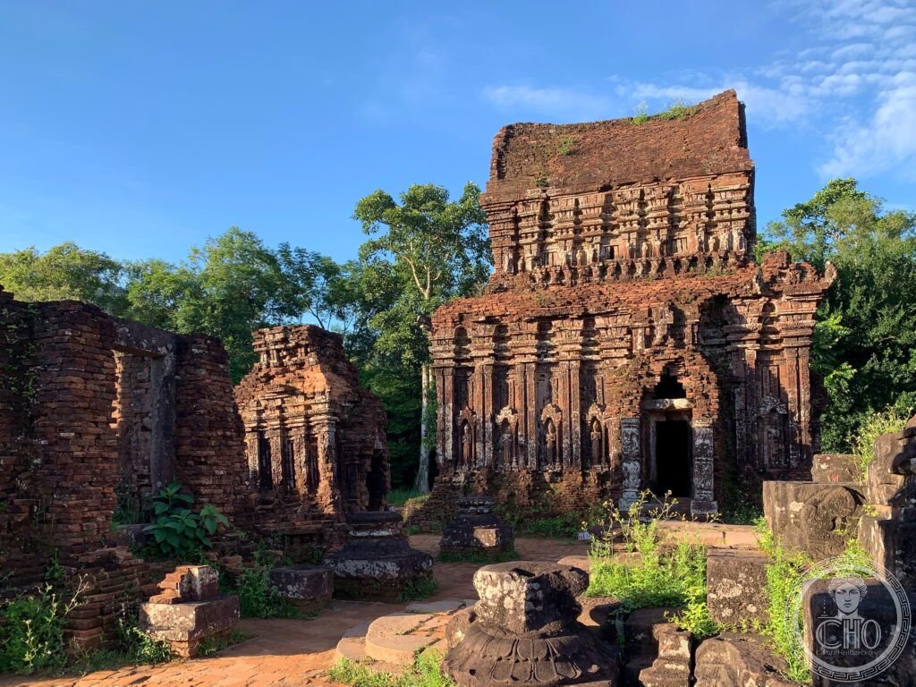
What you see
The surviving groups (the most precisely MySon single Group B C D Group G 8th 10th century kalan tower gopura mandapa kosagrha UNESCO heritage: the site is organized into lettered groups (Groups A through L; A is destroyed; Groups B, C, D are the main visitor area; Groups E, F, G, H, K, L are further into the site and require more walking): Group B, C, D (the main complex; 8th-9th century CE predominantly; the B1 tower (the largest surviving tower at Mỹ Sơn; 24m high; the principal sanctuary; sandstone carvings of apsaras on the exterior); B4 (the mandapa or ceremonial hall in front of B1; the entrance pavilion); B5 (the kosa-grha or “treasure house” — the repository of the temple’s sacred objects and votive gifts); the C group (a complete 8th century CE sanctuary complex in the area south of B; the C1 main tower; the C2 mandapa; the C3 kosa-grha; the C7 gate tower (gopura) — all clearly legible as a single organized complex; the only group at Mỹ Sơn where the full spatial arrangement of a Cham sanctuary complex is clearly readable to the non-specialist visitor)); Group G (separated from the main group; 10th century CE; a single well-preserved tower with the finest sandstone apsara carvings at the site) — the most precisely MySon single Group B C D Group G 8th 10th century kalan tower gopura mandapa kosagrha UNESCO heritage in any UNESCO world heritage site)).
Practical information
- Getting there: the standard access is from Hội An (50 km northwest; 1h by car/tour bus); the organized morning tours from Hội An (depart approximately 07:30-08:00; VND 150,000-300,000 for the bus; entrance fee to the site additional: VND 150,000; the most popular version returns via a traditional boat trip down the Thu Bồn River from the jetty at Duy Phú (approximately 1h30m; very pleasant; stops at a Cham cultural village)); alternatively, private car or motorbike from Hội An; the road (Highway 608; about 50 km; the last 10 km a dedicated road into the Mỹ Sơn valley); within the site (a small electric bus carries visitors from the entrance to the monuments (approximately 2 km); from the bus stop, the Groups B-C-D complex is 200m; Groups G-H-K are an additional 500m walk; allow 2-3 hours for the site; bring water (the valley is very hot and humid in summer); a visit at opening time (07:30) means fewer visitors and cooler temperatures; from April to October, afternoon thunderstorms are possible)
Getting there
From Hội An (50 km, 1h). Morning tours with river boat return are most popular. Entry VND 150,000. Open 06:30-17:00. Visit at opening time for fewer crowds. GPS: 15.7644, 108.1232.
Nearby
- Hội An Ancient Town — 50 km southeast (UNESCO WHS 1999; see separate entry); the most complete surviving Southeast Asian trading port town; the Japanese Covered Bridge; the 5 Chinese clan assembly halls; the silk lantern Full Moon Festival
- Trà Kiệu (Simhapura) — 15 km east of Mỹ Sơn; the ancient Cham political capital (the site is largely unexcavated and unvisited; a hill with traces of the ancient city walls; a Catholic church at the summit (built on top of the original Cham citadel hill; the parish priest has a small collection of Cham carved stones found on the hill); the contrast with the fully excavated Mỹ Sơn gives a sense of how much Cham archaeology remains below the ground throughout central Vietnam)
Sources
- Wikipedia, Mỹ Sơn; Kingdom of Champa; Cham architecture, accessed June 2026
- UNESCO, Mỹ Sơn Sanctuary, WHS reference 949, inscribed 1999
Find it on the map
See this place and what’s around it →📷 Diventa un fotografo di Cultural Heritage Online
Condividi le tue foto dei luoghi: restano pubblicate con la tua firma come autore. Più vengono viste, più ti fai conoscere — e presto un concorso premierà le foto più apprezzate.
Accedi o registrati gratis per aggiungere una foto