
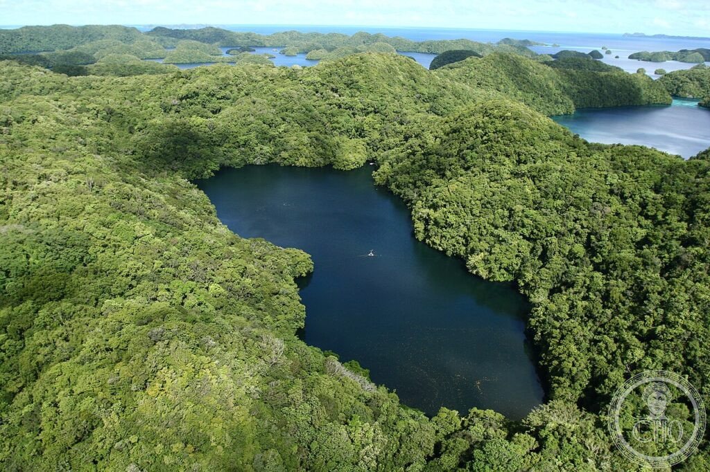
Some 445 uninhabited limestone islands rise mushroom-shaped from a turquoise lagoon in Palau, sheltering one of the most biodiverse marine ecosystems in the Pacific. Beneath the emerald canopy lie marine lakes, coral walls thick with sharks and turtles, and the wrecks of the Pacific War, all bound together by centuries of Palauan tradition.
At a glance
The Rock Islands Southern Lagoon lies within Koror State in the Republic of Palau, Micronesia. Around 445 uninhabited limestone islands are scattered across a lagoon of roughly 100 square kilometres, each island undercut at the waterline by wave erosion and topped with a closed canopy of forest growing straight from the rock. The lagoon was inscribed by UNESCO in 2012 as a mixed natural and cultural World Heritage Site, recognising both its marine biodiversity and the living Palauan traditions tied to it.
The enclosed waters act as a nursery for species that have declined on more exposed reefs elsewhere, supporting some 700 species of fish and around 400 species of coral, along with sharks, dugongs, saltwater crocodiles, and nesting green and hawksbill turtles. Water clarity on the outer reef walls is exceptional, often exceeding 40 metres of visibility.
Key facts
- Extent: around 445 uninhabited limestone islands across a 100 km² lagoon
- Status: UNESCO Mixed World Heritage Site, inscribed 2012
- Marine lakes: roughly 200 landlocked saltwater lakes within the islands, including Jellyfish Lake
- Marine life: around 700 fish species and 400 coral species, the largest coral diversity recorded in the Pacific
- War heritage: more than 60 Japanese and American wrecks from the 1944 Palauan Campaign
- Coordinates: 7.1200° N, 134.3600° E
History
The islands began as coral reefs during the last interglacial period, when sea levels stood several metres higher than today. As the sea later fell and the land was lifted by tectonic movement, a combination of freshwater erosion from above and saltwater erosion at the base carved the reefs into their present mushroom form. Left largely undisturbed, most islands developed a dense forest cover that survives to this day.
In 1944 the surrounding waters and the nearby island of Peleliu became the setting for one of the bloodiest engagements of the Pacific War, as American forces fought to take the island from its Japanese defenders. The conflict left dozens of wrecked ships and aircraft scattered across the lagoon floor, now among the most significant wreck-diving sites in the region.
The cultural dimension of the World Heritage listing reflects long-standing Palauan practices tied to the lagoon, including the traditional bai meeting house, the most elaborate style of building in Micronesia, and the bul, a customary system of fishing taboos that closes specific reefs during spawning seasons and remains in use today.
What you see
Divers and snorkellers come above all for Jellyfish Lake, a landlocked lake connected to the sea only through fissures in the limestone, home to millions of golden jellyfish that lost most of their sting after their population became isolated from the ocean thousands of years ago. Because the lake’s deeper waters are anoxic, only snorkelling is permitted there.
On the outer reef, Blue Corner draws grey reef sharks, napoleon wrasse, barracuda and tuna to a current-swept point where experienced divers use reef hooks to hold their position. The Blue Holes offer a series of vertical chimney caves descending through shafts of light to a sandy floor where marble rays rest, while Ulong Channel functions as a natural cleaning station for bumphead parrotfish, lionfish and white-tip sharks. Wreck dives reach sunken freighters, fighter aircraft and a former destroyer resting at depths of fifteen to thirty-five metres.
Practical information
- Access: entry into the Rock Islands lies within a protected marine sanctuary; a permit is required, and Jellyfish Lake needs a separate permit issued alongside it. Current arrangements and any charges should be checked with the Koror State authorities or local dive operators before travel.
- Best season: October to May brings drier conditions and the clearest water, with all dive sites accessible; the wetter months from June to September see lower visibility but Jellyfish Lake often at its most crowded with jellyfish.
- Base: most visitors stay in Koror, the main town, from where boats run out to the Rock Islands.
Getting there
Koror/Airai International Airport serves Palau with connections from Manila, Guam, Tokyo Narita, Seoul Incheon and Taipei. Under Palau’s Compact of Free Association with the United States, US citizens do not require a visa, and most other nationalities are issued a 30-day visa on arrival. From Koror, the Rock Islands are reached by boat.
Nearby
- Peleliu Island — a short boat journey south; site of the 1944 battle, with a museum in the former Japanese command building, the Orange Beach landing sites, the Bloody Nose Ridge cave system and a memorial to those killed in the fighting.
- Babeldaob Island — a short boat journey north; Palau’s main island, home to the Airai Bai, the country’s oldest traditional meeting house dating from the 15th century, the Ngardmau Waterfall, the largest in Micronesia, and the ancient stone monoliths of Badrulchau, Palau’s largest archaeological site.
Sources
- Wikipedia, Rock Islands Southern Lagoon
- Wikipedia, Jellyfish Lake
- Wikipedia, Battle of Peleliu
- UNESCO, Rock Islands Southern Lagoon, WHS reference 1386
Find it on the map
See this place and what’s around it →📷 Become a Cultural Heritage Online photographer
Share your photos of places: they stay published under your name as the author. The more they're seen, the more you get noticed — and soon a contest will reward the most appreciated photos.
Log in or sign up free to add a photo