
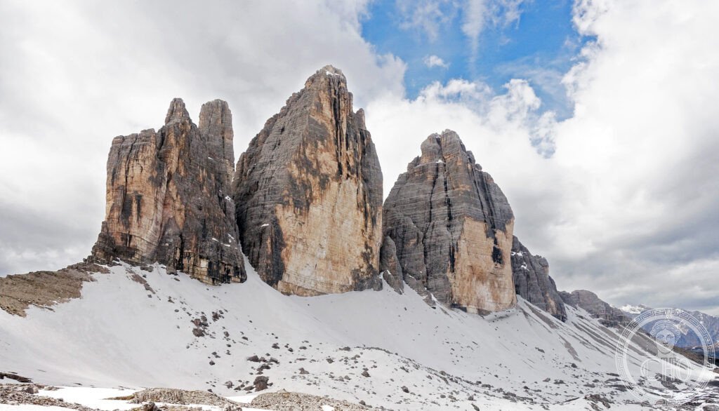
Pale limestone towers that were once a tropical coral reef now catch the sunset in a rose-orange glow the locals call Enrosadira. Between the sheer faces of Tre Cime di Lavaredo and the glacier of the Marmolada lies a landscape shaped by geology, war and a language, Ladin, spoken nowhere else on earth.
At a glance
The Dolomites stretch across Trentino-Alto Adige, Veneto and Friuli Venezia Giulia in northeast Italy, a range of pale limestone peaks that owes both its colour and its name to the mineral dolomite, first described by the French geologist Déodat Gratet de Dolomieu in 1791. The rock began as a tropical coral reef some 250 million years ago, and the collision of the African and Eurasian plates over the last 80 million years pushed it skyward into the jagged towers seen today.
UNESCO inscribed nine of the most spectacular Dolomite massifs, covering 141,903 hectares across the three regions, as a natural World Heritage Site in 2009. The mountain valleys are also home to Ladino speakers, whose language, Ladin, descends from Vulgar Latin and stands apart from Italian, French and Spanish.
Key facts
- Highest peak: Marmolada, 3,343 metres, known as the Queen of the Dolomites and home to the range’s largest glacier.
- Landmark formation: Tre Cime di Lavaredo, three limestone pinnacles reaching 2,999 metres at Cima Grande.
- Enrosadira: the alpenglow that turns the rock faces pink and then orange-red around sunset and sunrise.
- UNESCO status: inscribed in 2009 under natural criterion VIII, covering nine massifs across three regions.
- Local culture: the Ladino-speaking valleys preserve a Rhaeto-Romance language distinct from neighbouring tongues.
History
The rock of the Dolomites formed as a coral reef in a warm Triassic sea around 250 million years ago, long before the Alps existed. The same tectonic forces that built the wider Alpine chain later thrust these reef deposits upward, producing the pale, sheer-sided peaks that give the range its character.
During the First World War the Dolomites became a high-altitude front between the Italian and Austro-Hungarian armies, with fighting recorded at altitudes near 3,000 metres in extreme cold. At Lagazuoi the Italians drove some 12 kilometres of tunnels through the rock to mine Austrian positions, and traces of trenches, barbed wire and military structures still survive on several summits.
The mountaineer Reinhold Messner, born in South Tyrol and credited with climbing all fourteen of the world’s eight-thousand-metre peaks, later founded a network of mountain museums across the region devoted to Alpine history and culture.
What you see
The three towers of Tre Cime di Lavaredo, Cima Grande, Cima Occidentale and Cima Piccola, rise close together above the Sexten Dolomites; the north face of Cima Grande drops some 600 metres and is regarded as one of the classic Alpine climbs. A circular trail of around ten kilometres from Rifugio Auronzo takes walkers around all three peaks with close views of the rock faces.
Four long-distance routes, the Alta Via trails numbered AV1 to AV4, cross the range from north to south, linking a network of rifugi, mountain huts that offer meals and shelter at altitude and in many cases date back to the late nineteenth century. Alta Via 1, running from Lago di Braies to Belluno, is the best known, passing beneath the Tre Cime and through the Civetta and Pelmo massifs. At Marmolada a cable car climbs from Malga Ciapela to Punta Rocca, giving panoramic views across the range; the glacier below has visibly retreated in recent decades, and in July 2022 a large ice collapse from it killed eleven hikers.
Practical information
- Best season for walking: summer months, when the high trails and rifugi are open; many close between the ski and hiking seasons.
- Skiing: the Dolomiti Superski network links a dozen ski areas across the range; check current opening dates and conditions with the operator before travelling.
- Getting around: a car is effectively essential, as many trailheads and viewpoints lie well outside towns.
- Coordinates for Tre Cime: 46.4102° N, 11.8440° E.
Getting there
Venice’s Marco Polo airport is the usual gateway from most European cities, with Cortina d’Ampezzo around 160 kilometres away and Bolzano, convenient for Alpe di Siusi and the northern Dolomites, around 290 kilometres away. A hire car is the practical way to reach trailheads, rifugi and viewpoints scattered across the range.
Nearby
- Venice — around 160 km south; a UNESCO World Heritage Site since 1987, with the Grand Canal, Piazza San Marco and the Doge’s Palace.
- Innsbruck, Austria — around 100 km north; the Tyrolean capital, home to the fire-gilded Golden Roof and twice host of the Winter Olympics, in 1964 and 1976.
- Verona — around 130 km south; a UNESCO World Heritage Site since 2000, with its first-century Roman arena still used for opera and the setting Shakespeare gave to Romeo and Juliet.
Sources
- Wikipedia, Dolomites
- Wikipedia, Tre Cime di Lavaredo
- Wikipedia, Marmolada
- Wikipedia, Enrosadira
- UNESCO, The Dolomites, World Heritage Site reference 1237
Find it on the map
See this place and what’s around it →📷 Become a Cultural Heritage Online photographer
Share your photos of places: they stay published under your name as the author. The more they're seen, the more you get noticed — and soon a contest will reward the most appreciated photos.
Log in or sign up free to add a photo