Torres del Paine National Park
The most dramatic mountain landscape in the Southern Hemisphere and the trekking destination that has come to define adventure travel in South America — Torres del Paine, in Chilean Patagonia, gathers three vertical granite towers, turquoise proglacial lakes, and the largest glacier in the southern Andes outside Antarctica into a single national park that 100,000 trekkers a year describe as the most beautiful place they have ever been.
At a glance
Torres del Paine National Park (UNESCO Biosphere Reserve 1978; the park is not yet inscribed as a World Heritage Site but has been on the Chilean tentative list since 1994 — the most frequently anticipated UNESCO inscription in South America that has not yet materialised; the area (1,813 km²; the most concentrated vertical relief per km² of any national park in South America; the geology (the Paine Massif is composed of two geological elements that are unique in combination: an older black hornfels and shale (the dark igneous cap of the Cuernos del Paine — the most structurally complex mountain silhouette in Patagonia: the two “horns” are capped by black rock while the exposed granite core below is pale yellow, creating a two-toned mountain profile unlike any other in South America); the pale granite (the younger intrusive granite laccolith injected into the dark hornfels and then exposed by 2 million years of Patagonian glaciation — the most spectacularly exposed granite intrusion in the southern Andes)); the climate (the most unpredictable weather in any popular trekking destination: the Westerlies (the roaring forties and furious fifties — the most violent sustained wind system in the Southern Hemisphere) bring weather changes of 4 seasons in a single hour; the most reliable forecast in Torres del Paine is “the forecast is wrong”; the best months: November–March (the Southern Hemisphere summer); the most photographically productive months: November (wildflowers) and February–March (stable light, autumnal colours)).
Key facts
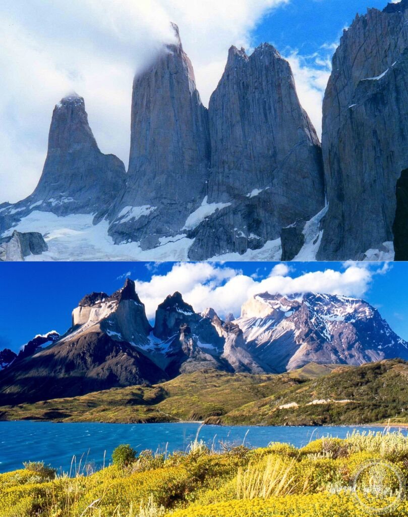
- The Torres del Paine — the three granite towers: the most iconic mountain silhouette in South America — Las Torres (the three granite pillars: the South Tower (Torre Sur; 2,850 m), the Central Tower (Torre Central; 2,800 m), the North Tower (Torre Norte; 2,500 m); together rising 1,600–1,800 m above Laguna Torres (the lake at their base); the first ascent (the South Tower (Torre Sur): first climbed by Armando Aste and a team of Italian climbers in 1963 — the most significant Italian mountaineering achievement in South America; the Central Tower (Torre Central): first climbed by the British expedition led by Chris Bonington and Don Whillans in 1963 — the same Bonington who later organised the first ascent of the South Face of Annapurna (1970) and the first British ascent of Everest (1975); the most celebrated individual climber-pair to both first-ascend separate towers of the same massif in the same season in the history of mountaineering)); the free climbing (the most technically challenging single-day rock climbing objective in Patagonia: the Eastpillar of Torre Sur (the most demanded single line on the massif for modern free climbers)); the Laguna Torres viewpoint (the most photographed single landscape moment in South America: the sunrise reflection of the three towers in the lake; reached from Refugio Las Torres (the main base camp) by a 2h uphill hike; the dawn (the most attended dawn in any national park in South America: in high season, 50–80 people stand at the lake edge waiting for the first light to hit the towers at 6–7am))
- The Cuernos del Paine and the glaciers: the full landscape of the massif — Cuernos del Paine (the Horns of Paine; the central massif rising to 2,600 m (Torre Cuerno Principal); the most visually complex mountain silhouette in South America: the characteristic two-toned profile (black hornfels cap / yellow granite base) visible from Lago Pehoe (the turquoise proglacial lake in the centre of the park); the view from Lago Pehoe (the most widely reproduced Torres del Paine photograph after the towers themselves: the turquoise-blue water, the Cuernos above, the Andes horizon behind)); the Grey Glacier (the largest glacier in the park; terminates in Lago Grey; the calving glacier (iceberg calving; the turquoise lake dotted with white icebergs — the finest accessible iceberg landscape outside Antarctica; the glacial kayak tours (the most extreme accessible water activity in the park)); the Southern Patagonian Ice Field (the largest temperate ice field in the Southern Hemisphere outside Antarctica: 16,800 km²; shared between Argentina and Chile; the most important freshwater reservoir in South America; Torres del Paine sits on its eastern flank)
- The W Trek and the O Circuit: the two defining trekking routes — the W Trek (the most popular multi-day trek in South America: the 72-km, 4-day route that follows the W shape through the most spectacular sections of the park (Laguna Torres — the towers; Valle del Francés — the hanging glaciers; Lago Grey — the glaciers and icebergs); approximately 70,000+ trekkers per year; the most internationally diverse single trekking event in South America (trekkers from 50+ countries on a peak-season week); the infrastructure (the refugios (mountain huts with beds, meals, and showers) make the W Trek the most comfortably served multi-day wilderness trek in South America; the most frequently booked-out refugio network in all of South America in January–February); the O Circuit (the full 115-km, 8–9-day circuit; the most complete single trekking experience in Torres del Paine; the Paso John Gardner (the most dramatic single mountain pass on the O Circuit: a 1,241-m pass over the Paine massif with the Southern Patagonian Ice Field on one side and the park’s eastern steppe on the other — the most geographically dramatic single pass on any popular South American trek))
- Heritage: UNESCO Biosphere Reserve, Torres del Paine National Park, designated 1978
- GPS: -51.0000° N, -73.0000° E
History
Indigenous peoples (the Tehuelche (Aónikenk) people — the most southerly hunter-gatherer culture in the Americas; they inhabited the Patagonian steppe including the area of Torres del Paine from approximately 10,000 BCE to the 19th century; the Tehuelche were nomadic hunters of guanaco (the most important prey animal in the Patagonian steppe; the ancestor of the llama; the most distinctively Patagonian large mammal); European exploration (Ferdinand Magellan became the first European to see the Patagonian coast in 1520 (the most important single European expedition in South American coastal geography)); the colonisation of Chilean Patagonia (19th century; the estancias (the sheep farms that replaced the indigenous people across the Patagonian steppe in the late 19th century — the most economically productive use of the Patagonian land in the European period; but the most ecologically damaging: the introduced sheep damaged the native steppe grasses and replaced the guanaco as the dominant grazing animal); the national park (established 1959 by the Chilean government — the most important single conservation decision in the history of Chilean natural heritage); UNESCO Biosphere Reserve 1978).
What you see
The Torres del Paine experience (the essential sequences: the W Trek (described in Key Facts); the day hike to Laguna Torres (the single best non-overnight hike in the park: 8h round trip from the park entrance; the 2h final uphill push to the lake; the towers at dawn); the Mirador Cuernos hike (a day walk to the best view of the Cuernos del Paine above Lago Nordenskjöld); the Grey Glacier boat tour (the most accessible glacier viewing: the Catamaran Grey crosses the lake and approaches within 100 m of the glacier face); the wildlife (the pumas (Torres del Paine has the highest density of pumas accessible to the public in South America; the best viewing is in the eastern steppe (the Amarga area) in the winter months (June–August) when the pumas follow the guanaco herds to lower elevations; the guanacos (approximately 4,000 in the park — the most densely populated wild camelid in a South American national park; the largest guanaco in the Paine massif area are the most photographed South American large mammals after the llamas of the Altiplano); the Andean condors (up to 3 m wingspan; the most reliably sighted large raptor in the park: the condors ride the thermal updrafts along the Paine massif from 10am onward).
Practical information
- Getting there: Punta Arenas Airport (PUQ; 330 km south; 4h 30min drive via Puerto Natales; the main international gateway for Torres del Paine; daily flights from Santiago de Chile (3h; LAN Chile and Sky Airline; the most frequent Chilean domestic route to Patagonia); from Buenos Aires (3h to Punta Arenas or fly to El Calafate (4h) and cross the border by bus (3h) to Puerto Natales)); Puerto Natales Airport (PMC; 110 km south; smaller; seasonal flights from Santiago and Punta Arenas; the most convenient gateway); by bus from Puerto Natales (2h 30min; Buses El Pingüino and other operators; the cheapest approach); the entrance fee (the most frequently changed fee in Chilean national park tourism: as of 2026, approximately USD 31,000 CLP (approximately USD 35) for foreigners in peak season; the most expensive Chilean national park entry fee); the refugios (the most important logistical fact: W Trek and O Circuit refugio and camping places MUST be booked months in advance for November–February; the most over-subscribed trekking reservation system in South America; the Vertice Patagonia and CONAF systems fill by February for the following November–March season)
- El Chaltén and the Fitz Roy massif (Argentina): the other side of the Patagonian mountain coin — El Chaltén (300 km north-east via Ruta 40 across the Argentine steppe; the Argentine counterpart to Torres del Paine; the most dedicated mountain trekking village in Argentina (population 2,000; the entire village exists for the Fitz Roy trek)); Cerro Torre (3,128 m; the most technically demanding single peak in Patagonia; first climbed by Cesare Maestri in 1959 — the most disputed first ascent in the history of alpinism; Maestri’s claim has never been fully accepted; the most contentious summit dispute in South American mountaineering history); the Fitz Roy (3,359 m; the most technically demanding summit in Patagonia for free climbers; the granite needle that defines the horizon east of Torres del Paine; the Patagonia clothing brand’s logo is a photograph of Fitz Roy — the most commercially reproduced single mountain silhouette in outdoor sportswear)
- Ushuaia and Tierra del Fuego: the southernmost city on Earth — Ushuaia (750 km south-east of Torres del Paine; 1h 30min flight from Punta Arenas (or 10h road via Río Gallegos); the most southerly city in the world (Ushuaia officially; Puerto Williams in Chile is more southerly but is a village not a city — the most precisely contested geographic superlative in the southern hemisphere); the Beagle Channel (named after the HMS Beagle (the ship that brought Charles Darwin to Tierra del Fuego in 1832–1833 — the most consequential single research voyage in the history of biology; Darwin’s observation of the Fuegian people and the Patagonian landscape contributed to the development of the theory of natural selection)); the Tierra del Fuego National Park (the most southerly national park in the world accessible by road; the end of the Ruta Nacional 3 (the Pan-American Highway at its southernmost point; the most southern highway terminus on Earth))
Getting there
Punta Arenas Airport (PUQ) 330 km (4h 30min) or Puerto Natales (PMC) 110 km. Bus Puerto Natales → park 2h 30min. Book W Trek refugios months in advance. Best months: November–March. GPS: -51.0000, -73.0000.
Nearby
- El Calafate and the Perito Moreno Glacier (UNESCO WHS 1981) — 250 km north-east via Río Turbio (3h 30min drive); the most accessible large advancing glacier in the world and the finest single-day natural heritage experience in Patagonia — Perito Moreno (the most famous glacier in South America: 30 km long; 5 km wide; 60 m high ice face; the only major glacier in Patagonia that is not retreating (the most frequently cited exception to global glacier retreat in climate change discussions; Perito Moreno advances approximately 2 m per day at the ice face — the most measurable single glacier advance in the southern Andes); the rupture (every 2–5 years, Perito Moreno blocks the Brazo Rico arm of Lago Argentino, building up until the ice dam breaks in a spectacular rupture — the most reliably scheduled natural spectacle in Patagonia; the last rupture (March 2023) attracted 50,000 spectators — the most attended single natural event in Argentine Patagonian history))
- The Magallanes Strait and Punta Arenas — 330 km south; the most historically significant strait in the history of navigation — the Strait of Magellan (the navigational passage between the Atlantic and the Pacific; discovered by Ferdinand Magellan in October–November 1520 (the most consequential single navigational discovery in the Age of Exploration; the Strait opened the Pacific to European navigation and changed the global trade routes for the next 350 years until the Panama Canal)); Punta Arenas (the most southerly city in continental South America; the hub for penguin colony visits (the Monumento Natural Los Pingüinos on Isla Magdalena: 200,000 Magellanic penguins — the most accessible large penguin colony in South America; 1h ferry from Punta Arenas); the cemeteries of Punta Arenas (the most elaborate 19th-century immigrant cemetery in South America: the Croat, German, British, and Spanish settlers who built the city at the bottom of the world left behind monumental mausoleums of the highest quality of any provincial cemetery in Chile))
- Isla de Chiloé and the Chilean Lake District — 1,000 km north (2h 30min flight from Punta Arenas to Puerto Montt); the finest island archipelago in Chile and the most architecturally distinctive heritage landscape in Patagonia — Chiloé (the Chiloé National Park + the traditional wooden palafitas (stilt houses) on the water + the UNESCO-inscribed wooden churches (2000; 16 Jesuit-built 18th-century wooden churches — the most unusual collection of wooden sacred architecture in South America; the Church of Achao (the oldest surviving wooden church in Chile); the curanto (the most elaborate single dish in Chilean regional cuisine: a stew of shellfish, sausages, smoked meats, and potato dumplings cooked over hot stones in a pit — the most earth-oven-cooked celebratory meal in Chilean culture))
Sources
- Wikipedia, Torres del Paine National Park; Patagonia; Cuernos del Paine, accessed June 2026
- UNESCO, Torres del Paine Biosphere Reserve, designated 1978
- Patrick Symmes, Patagonia: A Cultural History, Signal Books, 2009
Find it on the map
See this place and what’s around it →📷 Diventa un fotografo di Cultural Heritage Online
Condividi le tue foto dei luoghi: restano pubblicate con la tua firma come autore. Più vengono viste, più ti fai conoscere — e presto un concorso premierà le foto più apprezzate.
Accedi o registrati gratis per aggiungere una foto