Amalfi Coast
The most beautiful coastal landscape in Europe and the definitive image of southern Italian beauty — the Amalfi Coast (Costiera Amalfitana), a 40-kilometre sweep of Campania coastline where the Lattari Mountains drop almost vertically into the Tyrrhenian Sea, is a cultural landscape in which medieval villages, ancient lemon terraces, and Baroque churches are draped on cliffs above some of the most intensely blue water in the Mediterranean.
At a glance
The Amalfi Coast (UNESCO WHS 1997; “an outstanding example of a Mediterranean landscape, with exceptional cultural and natural scenic values resulting from its dramatic terrain and the historical process of human settlement” — the UNESCO inscription statement that most concisely describes the coast’s dual character); the 13 villages (the towns and villages of the Costiera Amalfitana: Vietri sul Mare; Cetara; Maiori; Minori; Atrani; Amalfi (the historic capital); Conca dei Marini; Praiano; Positano; and the hill villages above — Ravello, Scala, Tramonti, Furore); the cultural landscape (the most important concept at the heart of the Amalfi Coast WHS inscription: the landscape is not primarily natural but is the result of a continuous 2,000-year process of human modification of an extreme terrain; the terracing system (the fasce: narrow terraces supported by dry-stone walls cut into the cliff face to create horizontal surfaces for cultivation; the most extensive surviving terracing system on any Mediterranean sea cliff; the terraces support lemon groves, olive trees, and vineyards on slopes that would otherwise be bare cliff); the architecture (the buildings of the Amalfi Coast towns: the Arab-Norman style that reflects the coast’s medieval trade connections with North Africa and the Arab world; the distinctive vaulted cisterns under every building; the majolica tiles (the most colourful architectural ceramic tradition in Italy; the church domes tiled in green and yellow majolica that contrast with the white walls against the blue sea — the most frequently reproduced church dome silhouette in Italian travel photography)).
Key facts
- The Republic of Amalfi: the first Italian maritime republic and the inventors of the maritime compass rose — the Republic of Amalfi (the Duchy of Amalfi; the most historically significant polity in the history of the Amalfi Coast; the first Italian maritime republic (established before Venice, Genoa, and Pisa — the 4 Italian maritime republics that dominated Mediterranean trade in the medieval period); the peak period (9th–11th century CE; the city of Amalfi had a population of approximately 70,000 — larger than London or Paris at the same time — and traded across the entire Mediterranean from Egypt to Byzantium; the most influential single city in the history of Italian maritime commerce in the early medieval period); the Tabula Amalfitana (the codified maritime law of Amalfi, in force across the Mediterranean from the 11th to the 16th century — the most widely applied medieval maritime legal code; the document is held in the Museo Civico in Amalfi; the Flavio Gioia legend (the Italian inventor of the maritime compass (the most frequently attributed and the most frequently disputed technological invention in Italian history; the traditional narrative holds that Gioia of Amalfi invented or perfected the compass in the 14th century; the historical evidence suggests the compass was transmitted from China via the Arab world, but the Amalfitan sailors were among the first to use it in the Mediterranean; the most diplomatically handled disputed invention in Italian maritime history); the Duomo di Sant’Andrea (the most important building on the Amalfi Coast: the Cathedral of Saint Andrew the Apostle; the Arab-Norman facade (the 9th-century foundations; the 13th-century facade remodelled in the 19th century; the striped marble arches and mosaics are the finest example of Arab-Norman architecture in the Campania region); the crypt (the relics of St. Andrew the Apostle — the 14th-century marble sarcophagus and the bones themselves, which were said to exude a fragrant oil called the “Manna of St. Andrew” (the most fragrant relic phenomenon in any Italian cathedral crypt))
- Positano: the most vertical and most photographed village on the coast — Positano (the most photographed village on the Amalfi Coast and the most visited; the cascade of buildings from the clifftop (320 m) to the beach (0 m) in a single visual fall; the beach (the Spiaggia Grande; the main beach; 300 m of grey-black pebbles; the pebble colour (the volcanic origin of the pebbles from the Vesuvian eruption sediments reworked by the sea; the most mineralogically interesting beach sand on the Amalfi Coast); the access (Positano is accessible by road (the most terrifying 20-minute bus journey on the Amalfi Coast from Amalfi to Positano: hairpin turns with 1 cm of clearance between the bus and the cliff edge) and by sea (the ferry from Amalfi; the most relaxed approach; 30 min)); the shops (the Positano fashion (the cotton resort wear of Positano (the cotton dresses and separates made of the local mussola di Positano — a traditional lightweight cotton; the “Positano style” that became internationally fashionable in the 1960s after John Steinbeck wrote a Harper’s Bazaar article in 1953 describing Positano as “a dream place that isn’t quite real when you are there and becomes beckoningly real after you have gone” — the most influential single piece of American travel writing about any Italian coastal town)
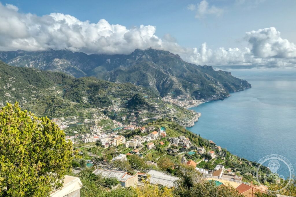
- Ravello and the gardens of the Villa Rufolo and Villa Cimbrone: the finest garden views in Italy — Ravello (the most elevated of the Amalfi Coast towns; perched 350 m above the sea on a spur of the Lattari Mountains; the finest town for panoramic views over the coast and for cultural tourism away from the beach); the Villa Rufolo (13th century; the gardens (the most famous garden view in Italy: the Belvedere of Infinity from the garden terrace (the terrace at the very edge of the cliff with an unobstructed 180° view over the Tyrrhenian Sea; the most frequently reproduced single garden view in Italy; Richard Wagner visited Ravello in 1880 and was so struck by the Villa Rufolo gardens that he set the second act of Parsifal in the garden of Klingsor — the most direct architectural inspiration for a major Wagnerian opera setting; the annual Ravello Festival (July–August; classical music performances held in the Villa Rufolo garden with the sea as backdrop — the most dramatically situated music festival in Europe)); the Villa Cimbrone (the most theatrical garden in Ravello; designed in the early 20th century by Lord Grimthorpe; the Belvedere of Infinity at the end of the garden (a long terrace of classical busts looking straight out over the Tyrrhenian Sea to the horizon; the finest single static view from any garden in Italy; Greta Garbo and Leopold Stokowski famously photographed here in 1938 when hiding from the press — the most romantic refugee episode in any Italian villa garden history))
- Heritage: UNESCO World Heritage Site, Amalfi Coast, inscribed 1997
- GPS: 40.6334° N, 14.6029° E
History
Ancient origins (the Greek and Roman use of the coast: villas (the most fashionable residential coast for the Roman elite from the 1st century BCE; the Emperor Augustus owned an estate on the coast; Tiberius preferred Capri, but the Amalfi coast towns served the imperial court via the harbour at Salerno); the Duchy of Amalfi (the most important period in Amalfi Coast history: the 9th–11th centuries CE; the maritime republic; the Tabula Amalfitana; the trade with Byzantium and the Arab world; the hospital in Jerusalem (the most important humanitarian institution in Crusader Palestine was founded by Amalfitans — the Hospital of Saint John in Jerusalem (1023 CE), which became the Knights Hospitaller, the most important military religious order in the history of the Crusades; an Amalfi merchant foundation is thus the origin of the Knights Hospitaller — the most consequential act of Italian merchant philanthropy in the medieval Mediterranean); the Norman conquest of the Duchy of Amalfi (1073 CE; the Norman armies of Robert Guiscard captured Amalfi; the end of the independent republic; the subsequent centuries of decline relative to its great medieval period)); the medieval period (the architecture: the Duomo di Sant’Andrea (Byzantine foundation; Arab-Norman facade; the Chiostro del Paradiso (the paradise cloister; 1268; the most beautiful cloister in Campania; the interlaced arches and palm trees)); the paper manufacture (the most important industry of the coast from the 13th century: Amalfi was the first city in Europe to manufacture paper (traditionally dated to 1231 CE; the most important single industrial innovation to arrive from the Arab world via the Italian maritime republics; Amalfi made paper of a specific kind — the Fabriano tradition (the Amalfi mills used hemp and linen rags; the finest paper in medieval Italy; the paper archives of the Vatican and major Italian archives were made of Amalfi paper); the Paper Museum in Amalfi (the Museo della Carta; the only museum in Italy dedicated to medieval paper manufacture; the operational mills demonstrating the traditional process); UNESCO WHS 1997.
What you see
The Amalfi Coast visit (the key route: the S.S. 163 Amalfitana (the state road between Vietri sul Mare and Positano; the most famous road in Italy; 40 km; approximately 2h by car without stops (the distance is short but the hairpin turns and traffic make it slow — and the views make it slower); the bus (the SITA bus from Amalfi to Positano or Amalfi to Salerno; the most hair-raising public transport in Italy; the bus drivers navigate hairpins at speeds that suggest they consider the cliff edge a mere aesthetic detail; the most discussed bus service in Italian travel writing)); the towns (Amalfi (the historic capital; the Cathedral; the paper museum; the harbour; the shopping street (Via dei Dogi; the most concentrated shopping street in the Campanian coast towns)); Positano (the cascade; the beaches; the fashion shops; the ferry connections); Ravello (the gardens; the festival; the most elevated and most tranquil town on the coast)); the Sentiero degli Dei (the Path of the Gods; the most dramatic walking trail on the Amalfi Coast: 7.8 km from Bomerano to Nocelle (above Positano); the coastal panorama (the view of the entire Amalfi Coast from above: the most comprehensive single terrestrial view of the coastline); duration: approximately 3h 30min; the most rewarding half-day activity on the coast for the physically fit).
Practical information
- Getting there: Naples Airport (NAP; Capodichino; 60 km north of Salerno (1h); the closest international airport; direct flights from the main European hubs and from the USA (Alitalia and Neos; New York JFK → Naples 9h 30min; the only direct transatlantic service to a south Italian airport)); the train to Salerno or Vietri (30 min from Naples Centrale by high-speed train to Salerno; then SITA bus along the S.S. 163 to Amalfi (1h) and Positano (1h 30min); the ferry (from Salerno or Naples to Amalfi by hydrofoil (SNAV or Caremar); 35 min from Salerno; 1h 30min from Naples; the most comfortable and most scenic approach to the coast)); the car (the most flexible approach but the most stressful: the S.S. 163 is extremely narrow; parking in Positano and Amalfi is extremely limited and expensive; the largest town to park and take the bus from is Maiori (the most practical parking base on the coast for day-trippers with cars)); the season (the most important decision for any Amalfi Coast visit: peak season (June–September) has traffic jams and queues that make the S.S. 163 impassable on weekends; the best visiting periods (May and October: warm enough to swim, uncrowded enough to drive; the most frequently recommended months in all Italian travel guides; November–April: the lemons are harvested; the tourists are absent; the towns are quiet; the light is extraordinary; the most local-authentic experience of the coast))
- Pompeii and Herculaneum (UNESCO WHS 1997): the most important Roman ruins in the world, 40 km north of Amalfi — Pompeii (the most visited archaeological site in the world after the Colosseum; 3 million visitors per year; the eruption of Vesuvius 79 CE (the most precisely dated catastrophe in classical antiquity: Pliny the Younger described it in two letters to Tacitus that are the most important first-hand account of a natural disaster in antiquity; the ash (the city was buried under 4–6 m of volcanic ash and pumice; the most perfectly preserved Roman city (streets, shops, bakeries, brothels, thermopolia (fast-food restaurants), private houses — all frozen in 79 CE; the most complete surviving snapshot of daily life in any Roman city)); Herculaneum (3 km from Pompeii; smaller but better preserved; the wooden elements (the roofs, beds, furniture, and carbonised food that survived at Herculaneum but were obliterated at Pompeii — the most complete organic material record of any Roman city; the eruption vapour (the Villa dei Papiri (the library of Hellenistic philosophical texts — the only surviving ancient library; the scrolls were carbonised by the 400°C pyroclastic surge; the papyri are being read by X-ray fluorescence tomography in 2026 — the most technologically advanced ancient text recovery project currently active))
- Paestum (UNESCO WHS 1998): the finest Greek temples in the world outside Greece — Paestum (80 km south of Amalfi; 1h 30min by car; the ancient Greek colony of Poseidonia (founded c.600 BCE; the most intact Greek temple precinct in the world outside Greece); the three temples: the Temple of Hera I (the “Basilica”; c.550 BCE; the oldest; 18 columns on the long sides; 9 at the ends); the Temple of Hera II (the “Temple of Neptune”; c.460–450 BCE; the finest Doric temple in the world: 6×14 columns; the entasis (the slight bulge of the columns — the correction for the optical illusion that makes straight columns look concave from a distance; visible to the naked eye at Paestum; the finest example of the Doric correction in any surviving Greek temple); the Temple of Athena (Ceres; c.500 BCE; mixed Doric-Ionic; the most transitionally stylistically interesting temple at Paestum); the museum (the most important collection of South Italian Greek art in Italy: the Tomb of the Diver (c.480 BCE; the only surviving Greek figural painted wall-tomb in the world — a unique fresco showing a banquet and a diver leaping into the sea from a diving board; the most discussed single archaeological painting in Magna Graecia; a mystery of interpretation (banquet = the symposium of the afterlife; the diver = the leap from life to death; the most poetic and most disputed funerary image in Greek art))
Getting there
Naples Airport (NAP) 60 km. Train to Salerno (30min from Naples), then SITA bus to Amalfi (1h) or Positano (1h 30min). Ferry from Salerno (35min). Best months: May and October. GPS: 40.6334, 14.6029.
Nearby
- Pompeii and Herculaneum (UNESCO WHS 1997) — 40 km north (1h by car or 45min by high-speed train Naples→Pompei Scavi); the most important Roman archaeological sites in the world — described in the Practical section; the essential Campania combination: 2 nights Amalfi Coast + 1 day Pompeii + 1 night Naples (the finest pizza in the world: the Vera Pizza Napoletana; the Associazione Verace Pizza Napoletana (AVPN) certifies that only 11 pizzerie in Naples use the original method; the pizza Margherita (created at the Pizzeria Brandi in 1889 for Queen Margherita of Savoy; the most royally celebrated street food in European history))
- Capri — 25 km offshore (40 min by hydrofoil from Sorrento; 1h from Positano by ferry; the finest island in the Bay of Naples); the Blue Grotto (Grotta Azzurra; the sea cave accessible only by rowboat through a 1-m-high entrance at low tide; the bioluminescence effect (the sunlight enters through an underwater opening and is refracted to create an extraordinary turquoise-blue glow on all surfaces inside the cave — the most celebrated optical phenomenon in any Italian sea cave; accessible only for 2h around low tide; the most unpredictable visit in Campania (if the swell is above 20 cm, the entrance is closed; the most frequently cancelled Italian heritage experience)); the Villa Jovis (the villa of Emperor Tiberius (r. 14–37 CE); the most important single Roman imperial ruin on any Italian island; the cliff (the Salto di Tiberio: the 333-m cliff from which Tiberius allegedly threw his enemies — the most violent reputation of any scenic viewpoint in Italy; the historical evidence for the throwing is weak but the view is excellent)
- Cilento National Park (UNESCO WHS 1998) — 80 km south of Amalfi (1h 30min by car); the most biodiverse national park in southern Italy and the landscape associated with the Mediterranean Diet (UNESCO Intangible Cultural Heritage) — the Cilento (the most remote inhabited landscape in Campania; 181,000 ha of national park; the Alburni Mountains (the finest karst landscape in southern Italy; the Castelcivita Caves (the most extensive cave system in Campania; 4,800 m of mapped passages)); the Paestum temples (at the northern edge of the Cilento; described in the Practical section); the Vallo di Diano (the archaeological park including Padula Monastery (the Certosa di San Lorenzo; the second-largest Carthusian monastery in the world; the Egg Frittata (the most unusual monastic kitchen record: on Easter 1534, the Certosa kitchen made a single omelette using 1,000 eggs to celebrate the visit of the Holy Roman Emperor Charles V — the most extravagant single egg preparation in any monastery record))
Sources
- Wikipedia, Amalfi Coast; Republic of Amalfi; Positano; Ravello, accessed June 2026
- UNESCO, Amalfi Coast, WHS reference 830, inscribed 1997
- Carlo Crispo Moncada, La Costa d’Amalfi: storia e cultura, Editore D’Amico, 1998
Find it on the map
See this place and what’s around it →📷 Diventa un fotografo di Cultural Heritage Online
Condividi le tue foto dei luoghi: restano pubblicate con la tua firma come autore. Più vengono viste, più ti fai conoscere — e presto un concorso premierà le foto più apprezzate.
Accedi o registrati gratis per aggiungere una foto