Purnululu National Park
The most extraordinary geological landform in Australia and one of the most visually spectacular natural landscapes in the world — the Bungle Bungle Range in Purnululu National Park in the East Kimberley of Western Australia, a vast field of rounded orange-and-black banded sandstone domes rising from the surrounding plain, was unknown to non-Aboriginal Australians until 1983 and remained unknown to most of the world for decades after that; yet it has been sacred to the Kija and Jaru peoples for at least 20,000 years.
At a glance
Purnululu National Park covers 239,723 hectares (approximately the size of Luxembourg) in the East Kimberley region of Western Australia, approximately 300 km south of Kununurra (the nearest town) and 750 km south-west of Darwin; the Bungle Bungle Range occupies the central-southern part of the park (approximately 45,000 hectares); the surrounding landscape is savanna grassland, seasonally dry creek beds, and ranges of spinifex-covered sandstone; the climate is extreme: the wet season (November to March) brings cyclonic rainfall that cuts all access roads; the Dry Season (April to November) is the visitor season; the park is only accessible by 4WD vehicle (the 53 km Purnululu unsealed access road from the Great Northern Highway requires a capable high-clearance 4WD; not suitable for 2WD vehicles or ordinary SUVs without low-range gearing) or by scenic flight from Kununurra (the only all-season access).
Key facts
- The Bungle Bungle geological formation: one of the most significant karst and pseudo-karst landforms in the world — the Bungle Bungle Range is composed of Devonian quartz sandstone (approximately 375 million years old) deposited in a shallow inland sea environment; the characteristic beehive dome form results from the differential weathering of the rock: alternating horizontal bands of silica-cemented sandstone (hard; weathers slowly; orange in colour from iron oxide staining) and permeable siliceous sandstone (soft; weathers more rapidly; dark grey-black from colonization by cyanobacteria and algae) created a rock mass with fundamentally different erosion rates at different levels; as the rock was exposed and weathered over 20 million years, the softer bands were undercut and removed while the harder bands projected outward, creating the bulging dome forms and the horizontal banding; the vertical fracture systems in the sandstone (joint sets running approximately perpendicular to each other) determined the spacing and shape of individual domes; the overall landscape is classified as a “pseudo-karst” landscape (resembling limestone karst but not formed by dissolution) and is one of the most outstanding examples of its type in the world
- Cathedral Gorge: the most impressive accessible natural space in the Bungle Bungle Range — Cathedral Gorge is a natural amphitheater carved into the heart of the Bungle Bungle Range over millions of years by seasonal floodwaters; the space (approximately 100 metres wide, 200 metres high) has been created by the collapse of a dome ceiling and the subsequent erosion of the underlying softer rock; the floor is sandy; the curving orange walls rise overhead in an almost perfectly circular formation; the acoustics are extraordinary (the enclosed hemispherical space creates a near-perfect natural reverb); the Aboriginal peoples have used Cathedral Gorge as a ceremonial gathering place; the 3 km return walk from the car park at the south end of the range traverses several smaller gorges and dome formations before reaching the amphitheater
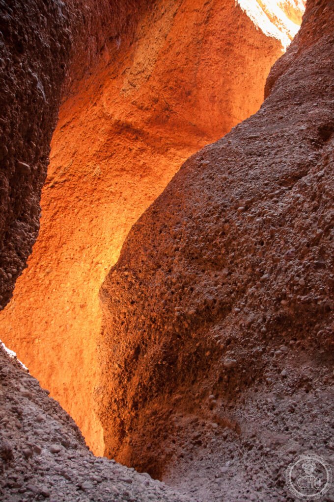
- Echidna Chasm: the most dramatic gorge walk in the Bungle Bungle Range — Echidna Chasm is an extremely narrow gorge (in places only 1–2 metres wide between vertical walls 200 metres high) cut through the northern massif of the Bungle Bungle Range; the name comes from the echidna (spiny anteater), which uses the chasm as a shelter; the chasm was formed by a combination of vertical fracture along a joint set and subsequent fluvial erosion by seasonal water flow; the floor is loose rock and gravel; the walk (2 km return from the northern car park) involves squeezing through sections where the walls almost touch overhead; the light at the end of the chasm, where it opens into a pocket of space with tall livistona palms (the most southerly population of this tropical palm species), is one of the most spectacular natural vignettes in the Kimberley
- The Kija and Jaru peoples: the Aboriginal custodians of Purnululu — Purnululu (the Kija word for “sandstone”) has been inhabited and sacred to the Kija and Jaru peoples for at least 20,000 years; the park contains numerous Aboriginal rock art sites (mostly accessed only by park rangers and Traditional Owners; not open to public visitors), sacred sites, grinding stones, and evidence of long-term occupation; the Kija people’s connection to the land at Purnululu is one of the key reasons the park was nominated for UNESCO inscription in 2001 (though the inscription was made purely on natural criteria in 2003); in 1987, the Western Australian government returned freehold title to the land to the traditional owners (the Kija Land Trust); the park is jointly managed by the Kija and Jaru custodians and the Western Australian Department of Biodiversity, Conservation and Attractions (DBCA)
- Heritage: UNESCO World Heritage Site, Purnululu National Park, inscribed 2003 (natural criteria outstanding geological value)
- GPS: -17.5000° S, 128.4167° E (central Bungle Bungle Range)
History
Aboriginal occupation at least 20,000 years; the Kija and Jaru people maintained the Country; European pastoral explorers traversed the surrounding Kimberley from 1878 but never documented the Bungle Bungle Range; the range was first known to non-Aboriginal Australians only in 1983 when a documentary film crew produced footage for the ABC television series Australia: The Real Thing — the footage of the domes caused immediate public and scientific interest; Purnululu National Park was proclaimed 1987; the Kija Land Trust received freehold title 1987; listed on the State Register of Heritage Places 1995; UNESCO WHS nomination submitted 2001; inscription 2003.
What you see
The park has two main visitor areas: the southern area (Cathedral Gorge, Piccaninny Creek, and the classic beehive dome views from the Domes Walk) and the northern area (Echidna Chasm, Mini Palms Gorge, and the Aboriginal cultural sites at Warmun); the two areas are connected by a roughly 50 km internal unsealed track; there are two campgrounds (Walardi in the south, Kurrajong in the north); the most photographed view of the domes is from the Domes Walk (1 km return, easy; the domes are most dramatically lit at dawn and dusk); the Cathedral Gorge walk (3 km return, moderate) is the most popular; the Echidna Chasm walk (2 km return, moderate; requires squeezing through very narrow sections; not suitable for visitors with claustrophobia or mobility limitations) is the most dramatic; all walks are best done in the early morning before the heat (temperatures reach 40°C+ in the afternoon from May to September, the warmest part of the Dry Season).
Practical information
- Access and entry fees: AUD $15 per adult per day entry fee; the park is open April–November (Dry Season) only; the 53 km unsealed access road from the Great Northern Highway (at Turkey Creek/Warmun roadhouse, 300 km south of Kununurra) is 4WD-only; check road conditions with the DBCA before departing; the road cannot be negotiated by conventional cars, 2WD SUVs, or caravans; scenic flights from Kununurra and Warmun are an excellent alternative if 4WD is not available (operators include Heliwork WA and East Kimberley Tours; 30–60 minute flights give an unmatched aerial perspective of the domes); camping: two campgrounds (Walardi in the south, Kurrajong in the north; basic facilities; no power; book at the park entrance; AUD $10–15 per night per vehicle); no accommodation or food available inside the park; the closest accommodation is at Warmun (Turkey Creek) or Kununurra
- Getting there: from Kununurra (300 km; approximately 3h 30 min by 4WD on unsealed road from the Great Northern Highway junction at Warmun): the drive from Kununurra on the Great Northern Highway to Warmun is 170 km of sealed road (2h); the Purnululu access road (53 km unsealed) takes a further 1h 30 min; from Halls Creek (100 km west on the Great Northern Highway; 1h 30 min sealed): the junction is 60 km east of Halls Creek; the most convenient alternative to driving is a scenic flight from Kununurra or a 4WD guided tour from Kununurra (multiple operators; full-day and multi-day trips; camping tours available)
- The Kimberley wilderness circuit: Purnululu is one of three exceptional natural attractions in the East Kimberley that combine into a multi-day circuit: Kununurra and Lake Argyle (the largest man-made reservoir in Australia; 18 times the volume of Sydney Harbour; the original Argyle Homestead was submerged when the dam was built in 1971; Argyle Diamond Mine — the world’s largest diamond mine by volume, source of 95% of the world’s pink diamonds, operated 1983–2020 and now closed and being remediated — is 70 km south), El Questro Wilderness Park (a private luxury wilderness station on the Gibb River Road, 100 km west of Kununurra; spectacular gorges including Zebedee Springs — natural hot springs in a palm-filled gorge — and the Emma Gorge), and the Mitchell Falls (Punamii-Unpuu) Plateau — the most remote and spectacular waterfall system in the Kimberley, accessible only by small plane or a 3-day 4WD drive along the Gibb River Road and Mitchell Falls Road
Getting there
4WD only via Great Northern Highway to Warmun (300 km from Kununurra, 3h 30 min). Scenic flights from Kununurra (30–60 min). No 2WD access. GPS: -17.5000, 128.4167.
Nearby
- Kakadu National Park — 750 km north-east of Purnululu (8h by road via Darwin and the Arnhem Highway; or by scenic flight from Kununurra); the most important Aboriginal rock art landscape in Australia and a UNESCO WHS since 1981 — the contrast between Purnululu (a primarily geological and Aboriginal cultural landscape in the hot, dry Kimberley sandstone country) and Kakadu (a floodplain, escarpment, and wetland landscape in the Top End with 5,000 rock art sites and an extraordinary biodiversity) gives the visitor a comprehensive experience of the extreme northern Australian wilderness; see separate CHO place card
- Nitmiluk National Park (Katherine Gorge) — 650 km north-east of Purnululu (7h by road); the most accessible gorge landscape in the Northern Territory — Nitmiluk features 13 sandstone gorges carved by the Katherine River; canoe self-hire and guided canoe trips through the gorges in the Dry Season are the primary activity; the contrast with Purnululu’s dome formations gives a complete picture of the Devonian and Precambrian sandstone landscapes of the Kimberley and the Top End
- Murujuga (Burrup Peninsula) Rock Art — 1,800 km south-west of Purnululu (20h by road; or fly from Broome to Karratha); the world’s largest collection of petroglyphs — the Murujuga (Burrup Peninsula) rock art complex near Karratha in the Pilbara of Western Australia contains approximately 1 million individual petroglyphs (engravings, not paintings; the distinction is important for preservation) carved into the red granite surfaces of the peninsula over at least 30,000 years; it is the world’s largest concentration of rock art by number of images; the oldest images include engravings of thylacines (Tasmanian tigers, extinct on the mainland approximately 3,000 years ago) and the faces of people who lived during the period when the nearby continental shelf was still dry land (sea level has risen approximately 100 metres since the Pleistocene, and the art documents the pre-inundation landscape); Murujuga was inscribed on the Australian Tentative UNESCO WHS List in 2020 and submitted for inscription in 2023
Sources
- Wikipedia, Purnululu National Park; Bungle Bungle Range; Kija people, accessed June 2026
- UNESCO, Purnululu National Park, WHS reference 1094, inscribed 2003
- Parks and Wildlife Service WA, Purnululu National Park Management Plan 2021–2031
- Derrick Ash, Bungle Bungle: A Journey Through the Purnululu National Park, Fremantle Arts Centre Press, 2000
Find it on the map
See this place and what’s around it →📷 Diventa un fotografo di Cultural Heritage Online
Condividi le tue foto dei luoghi: restano pubblicate con la tua firma come autore. Più vengono viste, più ti fai conoscere — e presto un concorso premierà le foto più apprezzate.
Accedi o registrati gratis per aggiungere una foto