Old City of Acre
The best-preserved Crusader city in the world and the last stronghold of the Frankish presence in the Holy Land — the Old City of Acre (Hebrew: Akko; Arabic: ‘Akka), built on a small peninsula projecting into the southern end of Haifa Bay, was the principal port of the Crusader Kingdom of Jerusalem for nearly two centuries (1104–1291) and the most contested city of the Mediterranean world in the 12th and 13th centuries; beneath the Ottoman-period city that visitors see today, the Crusader city lies largely intact one storey underground.
At a glance
Acre is a mixed Arab-Jewish city of approximately 50,000 residents on the northern shore of Haifa Bay; the Old City (the UNESCO WHS area) occupies the original peninsula, approximately 750 × 550 metres, and is separated from the modern suburbs by the sea walls on three sides; the Old City contains the Crusader underground city (the most important and most visited monument), the Great Mosque of Jazzar Pasha (the dominant landmark of the Ottoman-period skyline), the Khan al-Umdan caravanserai, the Ottoman bazaar, the Crusader sea walls (partially walkable), the Bah'i pilgrimage sites, and a dense residential quarter of stone houses. Acre is 25 km north of Haifa and 35 km south of the Lebanese border; it is easily accessible from Tel Aviv (1h 30 min by train) or Jerusalem (2h by train and bus).
Key facts
- The Crusader city (1104–1291) and the Knights Hospitaller: the most important Crusader monument in the world — Acre was captured by the Crusader forces of the First Crusade in 1104 and became the principal commercial port of the Kingdom of Jerusalem; after the fall of Jerusalem to Saladin in 1187, Acre became the de facto capital of the reduced Crusader state; the Knights Hospitaller (the Order of St John, a military-religious order founded in Jerusalem c. 1099) made Acre their principal base and built a vast compound (the Hospitaller Citadel) covering approximately 15,000 square metres in the centre of the city; the compound included the Great Hall (a magnificent 12th-century ribbed-vault hall 30 metres wide), a refectory, a knights’ dormitory, a church, a hospital (the purpose for which the Order was founded), a crypt, and an underground passage (the “Crusader Tunnel”, a 350-metre vaulted passage from the Hospitaller compound to the harbour, used for supply deliveries) — the Mamluk sultan Al-Ashraf Khalil captured Acre in May 1291 after a 43-day siege, massacring most of the population and demolishing the fortifications; the Ottoman ruler Jazzar Pasha built his palace and mosque directly on top of the Crusader compound in the 18th century, inadvertently preserving the Crusader structures beneath; excavations begun in 1991 have now opened the Crusader underground city to visitors
- The Crusader Tunnel (the “Templars’ Tunnel”): the most dramatic single monument of the underground Crusader city — the 350-metre-long vaulted stone tunnel connects the Crusader citadel to the harbour; it was re-discovered in 1994 by a woman in the old city whose toilet pipe collapsed, revealing the tunnel beneath her floor; the tunnel is wide enough for two people walking side by side; the vaulted ceiling (pointed Gothic arches throughout) is intact; it runs under the modern city streetlevel at a depth of approximately 4 metres; a visit to the tunnel (part of the Crusader Underground City ticket) involves walking the full length with lighting and an audioguide
- The Khan al-Umdan (Caravanserai of the Columns, 1784): the largest and most important Ottoman caravanserai in Israel — the Khan al-Umdan was built by the Ottoman governor Ahmad Pasha al-Jazzar (“the Butcher”, r. 1775–1804; the man who repelled Napoleon Bonaparte’s siege of Acre in 1799) over the ruins of a Crusader-period grain warehouse; the building takes its name from the 32 ancient granite columns (taken from the Roman ruins of Caesarea Maritima) that support the arched arcades of the ground-floor market; the clock tower at the entrance to the Khan (1906; added to commemorate the 30th anniversary of the accession of Sultan Abdulhamid II) is the most recognizable landmark of the harbour waterfront; the Khan al-Umdan is now an active souk and restaurant area
- The Bah'i Pilgrimage Sites: the holiest sites of the Bah'i Faith — Acre is the holiest city of the Bah'i Faith (a 19th-century religion founded in Iran that recognizes all the major prophets, including Moses, Jesus, Muhammad, and the Bab, and teaches the unity of all religions); Bah'u'lláh (Mirza Husayn-'Ali Nuri, 1817–1892), the founder of the Bah'i Faith, was exiled by the Ottoman government to Acre in 1868 and remained a prisoner there until his death in 1892; he was interred in the Mansion of Bah'jí 3 km north of Acre; the Shrine of Bah'u'lláh at Bah'jí is the most sacred site of the Bah'i Faith (the Qibla, the direction toward which Bah'is face in prayer); it is surrounded by formal Persian-style gardens; together with the Bah'i Shrine and Terraced Gardens on Mount Carmel in Haifa, it forms a single UNESCO WHS inscription (Bah'i Holy Places in Haifa and the Western Galilee, UNESCO 2008)
- Heritage: UNESCO World Heritage Site, White City of Tel-Aviv and Old City of Acre, inscribed 2001 (Acre as a standalone WHS; the Tel Aviv White City is a separate 2003 WHS)
- GPS: 32.9254° N, 35.0678° E
History
Acre has been settled since at least the Bronze Age (Tel Akko; the tell on the eastern edge of the peninsula holds 4,000 years of stratified deposits); the Phoenician port (approximately 8th–4th centuries BC) preceded Alexander the Great’s conquest (332 BC); the Crusaders captured the city 1104; it became the capital of the Crusader Kingdom after 1187; the Knights Hospitaller built their compound in the 12th–13th centuries; the city fell to Mamluks in 1291; the Ottoman period (1517–1918) saw the construction of the Khan al-Umdan (1784) and the Jazzar Pasha Mosque (1781); Napoleon besieged Acre unsuccessfully in 1799; the British Mandate period (1918–1948); the War of Israeli Independence (1948); the Israeli city of Akko was established; UNESCO WHS inscription 2001.
What you see
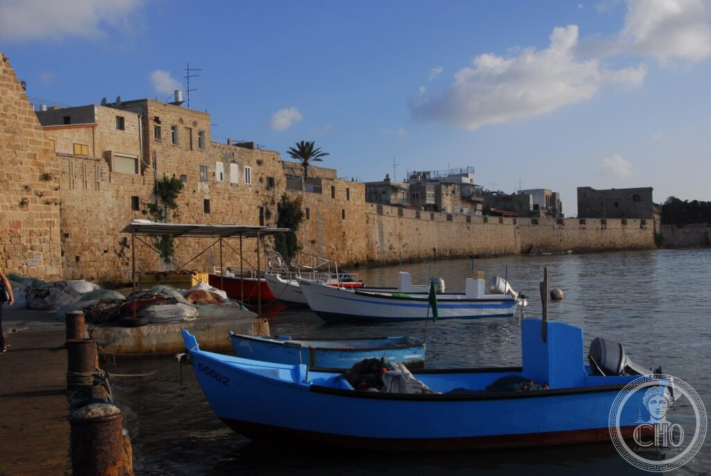
Enter the Old City via the Land Gate (the main Ottoman-period gate on the east side); walk south-west through the Ottoman bazaar to the Jazzar Pasha Mosque (the central landmark; the most important mosque in the Galilee; the dome and the minaret are visible from the harbour; the green courtyard is typically accessible to respectful non-Muslim visitors; the crypt beneath the mosque reportedly holds Jazzar Pasha’s treasure, now used as a museum); the entrance to the Crusader Underground City (the Hospitaller Citadel and the Crusader Tunnel) is across the street from the mosque (the ticket office is shared); allow 90 minutes for the underground city; exit via the Crusader Tunnel to the harbour; the Khan al-Umdan is at the harbour entrance (the clock tower is unmistakable); walk the sea walls (the Ottoman walls on the north and west are partially accessible for free; the view from the Al-Bosta tower over Haifa Bay is one of the best panoramas in northern Israel).
Practical information
- Admission: the Crusader Underground City and Hospitaller Citadel: approximately 50 NIS (Israeli new shekels; approximately €12); open Sunday–Thursday 8:30am–6pm, Friday 8:30am–5pm, Saturday 9am–6pm (hours vary seasonally; check current at the site); the Old City is generally open for walking at all hours; the Jazzar Pasha Mosque has its own entrance fee (approximately 10 NIS) and is closed during prayer times; the Bah'i Shrine at Bah'jí is free and is open daily (the gardens are particularly well maintained)
- Getting there: from Haifa: train from Haifa Central (HaMifratz; the northern Haifa station) or Haifa Bat Galim to Akko station (approximately 25 minutes; trains run every 30 minutes on weekdays; the station is on the outskirts of the Old City, approximately 15 min walk); by car from Tel Aviv: 1h 30 min north via Route 2 (coastal highway) or Route 4 (inland); from Jerusalem: 2h by bus (change at Haifa or Carmiel); by car from Haifa: 25 minutes north; bus No. 251 runs between Haifa Central Bus Station and the Acre bus terminal (approximately 35 minutes)
- Haifa and the Carmel circuit: Acre is typically combined with Haifa in a northern Israel day trip: from Acre (north Haifa Bay) to Haifa Central (the Hadar and Mount Carmel districts), the Bah'i Terraced Gardens (the “Hanging Gardens of Haifa” on the Carmel slope above the German Colony; UNESCO WHS 2008; 19 terraces of immaculate Persian-style formal gardens leading up the mountain to the golden-domed Shrine of the Bab at the summit — one of the most impressive and perfectly maintained landscapes in the Middle East), and the German Colony (Kolonistenviertel; the 19th-century colony of German Templer settlers on the waterfront beneath the Bah'i gardens; now a restaurant and café district)
Getting there
From Haifa by train (25 min, trains every 30 min). From Tel Aviv (1h 30 min by car north on Route 2). GPS: 32.9254, 35.0678.
Nearby
- White City of Tel Aviv — 100 km south of Acre (1h 30 min by train); the largest concentration of Bauhaus/International Style architecture in the world and the finest surviving example of a planned Modernist city — the White City of Tel Aviv (UNESCO WHS 2003) is a remarkable urban ensemble of over 4,000 buildings constructed in the International Style (Bauhaus) in Tel Aviv between approximately 1930 and 1950; the architects (many of them trained at the Bauhaus school in Dessau and Berlin before its forced closure in 1933) fled Nazi Germany and brought the modernist vocabulary to Tel Aviv, then a city of rapid Jewish immigration; the result is the world’s largest urban concentration of International Style architecture; the Bauhaus Center Tel Aviv (Dizengoff Street) is the best starting point; the evening guided walking tours (published Tuesdays, self-guided routes also available) are the most efficient way to see the principal buildings; see separate CHO place card
- Masada — 300 km south of Acre (3h 30 min by car); the most dramatic surviving monument of the Jewish resistance to Rome and the paramount symbol of Israeli national identity — Masada (Hebrew: מצדה; an isolated flat-topped rock mesa rising 450 metres above the Dead Sea shore in the Judean Desert) was the site of Herod the Great’s mountain palace-fortress (c. 37 BC; the most extravagant example of Herodian architecture in Israel — three-tiered hanging palace on the north face of the rock, bath-house, synagogue, columbarium, massive cisterns, Roman-style fresco decoration throughout); after Herod’s death it became a Roman garrison; in 66 AD it was captured by a group of Jewish Zealots at the start of the Great Jewish Revolt; the Roman siege (73–74 AD) built a siege ramp against the western face of the rock; when the Romans finally breached the wall, the 960 defenders (men, women, and children) committed mass suicide rather than surrender; the site is a powerful symbol of Jewish resistance; UNESCO WHS 2001; see separate CHO place card
- Ancient Caesarea (Caesarea Maritima) — 60 km south of Acre (50 min by car); the greatest Roman city in ancient Israel and the most spectacular Herodian harbour — Caesarea Maritima was built by Herod the Great (r. 37–4 BC) between 22 and 10 BC as a new Roman-style port city with the largest artificial harbour in the ancient Mediterranean (Sebastos Harbour; constructed entirely of opus caementicium poured in the sea; 50 × 40 hectares; the concrete seawall — one of the earliest uses of hydraulic concrete — is still partially preserved underwater); the city was the capital of the Roman province of Judaea (later Syria-Palaestina) and the official residence of the Roman governors of Judaea, including Pontius Pilate (a dedicatory inscription in Latin mentioning Pilate was found here in 1961); the Herodian theatre (restored), the hippodrome (partially excavated), the Roman aqueduct (partially standing above the beach), and the Crusader fortifications are all visible in the National Park
Sources
- Wikipedia, Acre, Israel; Crusaders in the Levant; Knights Hospitaller; Jazzar Pasha, accessed June 2026
- UNESCO, Old City of Acre, WHS reference 1042, inscribed 2001
- Adrian Boas, Crusader Archaeology: The Material Culture of the Latin East, Routledge, 1999
- Benjamin Z. Kedar, The Franks in the Levant, 11th to 14th centuries, Variorum, 1993
Find it on the map
See this place and what’s around it →📷 Diventa un fotografo di Cultural Heritage Online
Condividi le tue foto dei luoghi: restano pubblicate con la tua firma come autore. Più vengono viste, più ti fai conoscere — e presto un concorso premierà le foto più apprezzate.
Accedi o registrati gratis per aggiungere una foto