
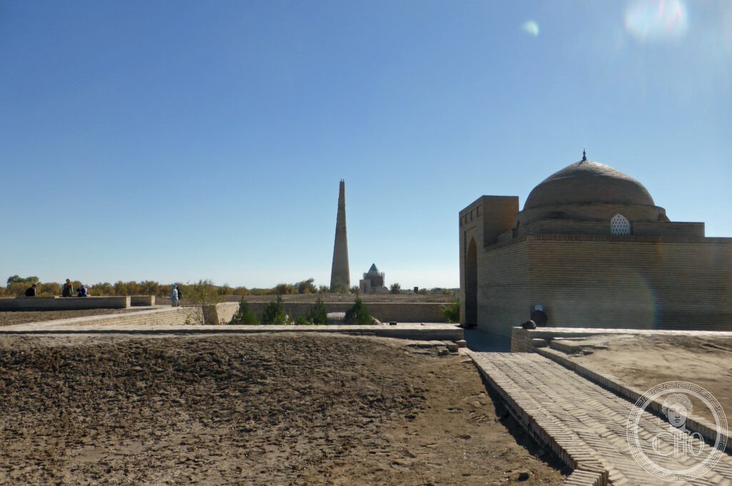
The greatest medieval Islamic city of Central Asia after Samarkand, and one of the most completely destroyed cities in history — Kunya-Urgench (ancient Gurganj), the capital of the Khwarazmian Empire, was one of the most wealthy and sophisticated cities of the 13th-century Islamic world; Genghis Khan destroyed it utterly in 1221 (flooding the ruins by diverting the Amu Darya); the surviving 10th–14th-century monuments, including the tallest pre-modern minaret in Central Asia and some of the finest Seljuk funerary architecture in the world, make it a place of extraordinary historical poignancy.
At a glance
Kunya-Urgench (Turkmen: Köneürgenç, “Old Urgench”) lies in the Dashoguz province of north-western Turkmenistan, 450 km north of Ashgabat (the Turkmen capital) and 90 km south-west of Urgench (the modern city in neighbouring Uzbekistan, which took over the name). The surviving monuments are scattered across a wide area of flat steppe; a visit requires a car (or a guided tour from Urgench, Uzbekistan, which is the most common approach for foreign visitors); allow half a day for the principal monuments. Note that Turkmenistan has a highly restrictive visa regime (one of the most difficult countries in the world to visit independently): most visitors arrive on a transit visa or a private guided tour; independent access to the ruins is possible in principle but logistics are complex.
Key facts
- The Khwarazmian Empire (c. 1190–1231) and the destruction by Genghis Khan (1221): the most powerful Islamic empire of Central Asia in the early 13th century and the most spectacular victim of the Mongol conquests — the Khwarazmian Empire under Sultan Muhammad II (r. 1200–1220) controlled most of modern Iran, Uzbekistan, Turkmenistan, and Afghanistan; its capital Gurganj (Kunya-Urgench) was one of the wealthiest and most sophisticated cities in the Islamic world, with a population estimated at 100,000–200,000 and a tradition of scholarship that had produced figures like al-Biruni and al-Khwarizmi (whose name gave the word “algorithm” to the English language); in 1218, Sultan Muhammad made the fatal error of executing the entire Mongol trade caravan (approximately 500 merchants) sent by Genghis Khan — an act of inexplicable political recklessness that triggered the Mongol invasion; Genghis Khan sent an army of approximately 200,000 to Central Asia; the Khwarazmian cities were systematically conquered and their populations massacred; Gurganj held out longest (6 months) and received the most thorough punishment: after the surrender, the city was flooded by the diversion of the Amu Darya (the Oxus river), destroying all surviving structures; medieval sources (with characteristic exaggeration) report 1.2 million killed; the actual number was certainly in the tens of thousands but the destruction was total
- The Kutlug-Timur Minaret (c. 1011 AD, Khwarazmshah Altuntash): the tallest pre-modern minaret in Central Asia and the dominant landmark of the site — the Kutlug-Timur Minaret (named after a Mongol-period governor rather than its Khwarazmian builder; originally attached to the Friday mosque, which has not survived) stands 62 metres high; it is built entirely of fired brick in a complex geometric pattern that changes design at each tier (12 different patterns of brick coursing from base to summit); the minaret survived the Mongol destruction and was used as a navigational landmark for caravans crossing the Kara Kum desert for centuries after the city was abandoned; it is the best-preserved large medieval brick minaret in Central Asia (comparable in height and type to the Kalon Minaret in Bukhara but taller and earlier)
- The Mausoleum of Tekesh (1200 AD): the finest surviving Seljuk funerary monument in Central Asia — the mausoleum of Sultan Tekesh ibn Il-Arslan (r. 1172–1200), the founder of the Khwarazmian Empire, was completed in 1200 as his funerary monument; the exterior is a cylindrical brick drum with a conical cap (the form derived from the Seljuk tent-tomb tradition of Central Asia); the interior contains the most complex brick ribbed vault in medieval Central Asian architecture, with an intricate interlocking pattern of raised and recessed brick segments creating a three-dimensional geometric surface of unusual sophistication; the exterior is decorated with terracotta tile patterns in the same family as the Kutlug-Timur Minaret
- The Mausoleum of Il-Arslan (c. 1172 AD): the oldest surviving building at Kunya-Urgench and the prototype for the Tekesh mausoleum — Il-Arslan ibn Atsiz (r. 1156–1172; the father of Tekesh) built the first significant Khwarazmian funerary monument at Gurganj; the building is simpler than the Tekesh mausoleum (a square chamber below a conical dome) but is the earliest example of the architectural style that would develop into the great Khwarazmian monuments; the terracotta tile panels on the exterior are the finest surviving examples of 12th-century Central Asian geometric tilework
- Heritage: UNESCO World Heritage Site, Kunya-Urgench, inscribed 2005
- GPS: 42.3209° N, 59.1497° E
History
Gurganj (the ancient name of Kunya-Urgench) is mentioned in Sasanian Persian sources as a city of Khwarezm; it became the capital of the local Afrigid dynasty approximately 900 AD; under the Khwarazmian shahs it grew into a major metropolis (10th–12th centuries); the Kutlug-Timur Minaret was built c. 1011; Tekesh mausoleum completed 1200; the Mongol destruction occurred 1221; the city was rebuilt under the Mongol Il-Khanate (13th century) and had a second flourishing under Timurid patronage (early 15th century); the Amu Darya changed course away from the city in the 16th century, removing the city’s water supply and trade route; the city was gradually abandoned; the ruins were not archaeologically investigated until the Soviet period (1940s–1970s); UNESCO inscription 2005.
What you see
The principal monuments are scattered across approximately 5 km of flat terrain; the best approach is to visit in sequence from south to north: the Mausoleum of Il-Arslan (the oldest building; the conical form is visible from a distance); the Mausoleum of Tekesh (the most architecturally sophisticated; examine the vault from inside); the Kutlug-Timur Minaret (the dominant landmark; the mosque it originally served no longer survives; the changing geometric tile patterns at each tier are most clearly visible in the low morning or afternoon light); the Sultan Ali Mausoleum (15th century; the most intact Timurid-period building at the site); and the Caravanserai ruins (the remains of the 13th-century caravanserai that served the site in the immediate post-Mongol rebuilding phase).
Practical information
- Admission and access: Turkmenistan is one of the most difficult countries in the world to visit independently; most foreign visitors enter on a 5-day transit visa (obtainable on arrival at Ashgabat Airport or the Uzbekistan land borders) or on a tourist visa arranged through an approved Turkmen tour operator; a local guide is typically required for independent travellers; the nearest international airport is at Urgench (Uzbekistan), 90 km north-east of Kunya-Urgench; the border crossing at Shawat/Khodjeyli is open for tourist traffic but requires advance paperwork; admission to the Kunya-Urgench UNESCO WHS zone: a nominal fee collected at the site entrance (approximately $5)
- Getting there: most practical route for independent travellers: fly to Urgench Airport (Uzbekistan) from Tashkent or Moscow; hire a car and guide in Urgench for a day trip to Kunya-Urgench; cross the Turkmen border at Shawat (approximately 90 km from Urgench city; have your transit/tourist visa ready); drive 20 km to the site (approximately 1h from the border); alternatively, fly to Ashgabat (the Turkmen capital) and take a domestic flight or long-distance car journey (450 km north; approximately 6h by car)
- The Silk Road Central Asia circuit: Kunya-Urgench is best visited as part of a Silk Road circuit that includes the major monuments of Uzbekistan: Khiva (Itchan Kala; UNESCO WHS 1990; the most perfectly preserved ancient city in Central Asia; 45 km from Urgench), Bukhara (Historic Centre; UNESCO WHS 1993; the most important sacred city of the Silk Road Islamic world; the Kalon Minaret, the Kalon Mosque, the Mir-i-Arab Madrasa, the Samanid Mausoleum), and Samarkand (Historic Centre; UNESCO WHS 2001; Timur’s capital; the Registan, the Bibi-Khanym Mosque, the Shah-i-Zinda necropolis, the Gur-e-Amir mausoleum of Timur)
Getting there
Fly to Urgench (Uzbekistan); hire car+guide; cross Turkmen border at Shawat (90 km from Urgench). Or fly to Ashgabat then 6h by car north. GPS: 42.3209, 59.1497.
Nearby
- Itchan Kala (Khiva) — 45 km north-east of Kunya-Urgench (45 min by car); the most perfectly preserved ancient walled city in Central Asia and the essential UNESCO WHS of the region — Khiva (Xiva in Uzbek) is a city on the Amu Darya that was founded according to tradition by Shem, son of Noah, and was a major centre of the Silk Road from at least the 10th century; Itchan Kala (the inner walled city, 650 × 400 metres) is an extraordinary concentration of 18th–19th-century Uzbek Islamic architecture: minarets, madrasas, mosques, caravanserais, and khans’ palaces in a perfectly intact walled enclosure; the city is essentially a living architectural museum of the Silk Road period; the Kalta Minor (unfinished short minaret, 1852; the largest diameter base of any minaret in the world; the Khan who ordered it died before it was completed, and it was never built to full height); the Islam Khodja Minaret (1910; the tallest minaret in Khiva; 45 metres); the Tosh-hovli Palace (the harem palace of Muhammad Amin Khan; the most elaborately decorated interior in Khiva); UNESCO WHS 1990; see separate CHO place card
- Historic Centre of Bukhara — 430 km south-east of Kunya-Urgench (4h by car or 3h by train); the holiest city of the Silk Road Islamic world and the most architecturally rich medieval Islamic city in Central Asia — the Historic Centre of Bukhara (Buxoro in Uzbek) preserves the most complete urban fabric of a medieval Silk Road city; the essential monuments are: the Samanid Mausoleum (907 AD; the oldest intact brick mausoleum in the Islamic world; the interlocking basket-weave brick pattern of the exterior is one of the most refined surfaces in Islamic architecture), the Kalon Minaret (1127 AD; 46.5 metres; the second-tallest pre-modern minaret in Central Asia; legend holds that Genghis Khan was so impressed by its beauty that he ordered it left standing when he destroyed the rest of Bukhara), the Mir-i-Arab Madrasa (1536; the most famous Sufi school in Central Asia; still an active Islamic seminary), and the Poi Kalon complex (the Friday Mosque, the Kalon Minaret, and the Mir-i-Arab Madrasa together forming the most important monumental ensemble in Bukhara); UNESCO WHS 1993; see separate CHO place card
- Historic City of Merv (Ancient Merv) — 680 km south of Kunya-Urgench (7h by car or by train via Ashgabat); the greatest Silk Road city in Turkmenistan and the largest medieval city in the world at its peak — Merv (ancient Margiana; modern name: Mary) was the largest city in the world around 1150 AD, with a population estimated at approximately 500,000 (comparable to Cairo); it was destroyed by the Mongols in 1221 (in the same campaign that destroyed Kunya-Urgench) and again by the Timurids in 1390; the surviving monuments include the Mausoleum of Sultan Sanjar (1157 AD; the finest surviving Seljuk building; the turquoise glazed dome visible from 40 km across the Kara Kum desert), the remains of five successive city enclosures from different periods (from Achaemenid to the later Islamic), and the Great Kyz Kala (the most extraordinary pre-Islamic building in Turkmenistan, a Sasanid-period monumental structure with corrugated exterior walls of uncertain function); UNESCO WHS 1999; see separate CHO place card
Sources
- Wikipedia, Kunya-Urgench; Khwarazmian Empire; Kutlug Timur Minaret, accessed June 2026
- UNESCO, Kunya-Urgench, WHS reference 1199, inscribed 2005
- John Man, Genghis Khan: Life, Death and Resurrection, Bantam Press, 2004
- Richard N. Frye, The History of Ancient Iran, C.H. Beck, 1984 (Khwarazmian historical context)
Find it on the map
See this place and what’s around it →📷 Become a Cultural Heritage Online photographer
Share your photos of places: they stay published under your name as the author. The more they're seen, the more you get noticed — and soon a contest will reward the most appreciated photos.
Log in or sign up free to add a photo