Nemrut Dağ (Mount Nemrut)
One of the most improbable and haunting monuments of the ancient world — on the summit of Nemrut Dağ (Mount Nemrut, 2,134 m) in the mountains of south-eastern Anatolia, the Hellenistic king Antiochus I of Commagene (c. 70–36 BC) built his own mausoleum surrounded by colossal stone statues (8–10 metres tall) of deities who combined Greek and Persian identities — a declaration of his own divine ancestry from both Alexander the Great and the Persian Achaemenid royal line; earthquakes toppled the heads from the bodies and they now stand in a field of monumental stone faces looking out over the Euphrates valley and the Anatolian plateau, one of the most extraordinary sights in the Middle East.
At a glance
Nemrut Dağ (Turkish: Nemrut Dağı, sometimes anglicised as Mount Nemrud) is in the eastern Taurus mountains of Adıyaman Province, south-eastern Turkey, 87 km north of Adıyaman city and 60 km north of the district town of Kahta. The site consists of the summit of Nemrut Dağ (2,134 metres above sea level) with a 50-metre-high tumulus (burial mound of crushed rock) at the peak, surrounded on three sides (east, west, and north) by terraces carved into the rock and decorated with colossal limestone statues and relief slabs of the late 1st century BC. UNESCO inscribed Nemrut Dağ in 1987 (UNESCO WHS reference 448) as an outstanding example of the syncretic Hellenistic-Oriental culture of the Commagene Kingdom. The site is remote, at altitude, and accessible only by minibus or 4WD from Kahta on a mountain road (the last 7 km unpaved); it is visited primarily at sunrise and sunset for the dramatic lighting on the stone heads.
Key facts
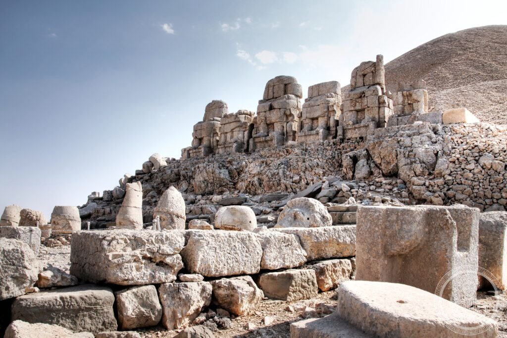
- The colossal statues (c. 70–36 BC): on both the east and west terraces, five identical sets of enthroned colossal figures (each originally 8–10 metres tall, with heads carved separately and set on the bodies) represent the deities of Antiochus’ syncretic religion — from left to right: (1) Apollo-Mithras-Helios-Hermes (the sun god, combining the Greek Apollo with the Iranian Mithras and the Mesopotamian sun deity, depicted with a halo of sun rays in the stone); (2) Tyche-Fortuna (the goddess of Fortune, depicting the land of Commagene as a goddess, wearing a crown of fruits and city towers); (3) Zeus-Oromasdes (the supreme deity, combining the Greek king of the gods with the Iranian Ahura Mazda/Oromasdes, the supreme principle of light in Zoroastrian religion); (4) Antiochus I of Commagene himself (the king seated as an equal among his divine ancestors); (5) Artagnes-Hercules-Ares (the warrior god, combining the Greek Hercules and Ares with the Iranian Verethragna); each figure is identified by inscriptions carved on the throne-backs; the eagle and the lion (sacred animals of the sun and the warrior deities respectively) stand as flanking guardian figures; after the earthquakes (date uncertain, 1st–3rd century AD), the massive heads fell forward and are now scattered at the base of the throne bodies — a field of stone faces (the eagle, the lion, and the five deities) looking in different directions across the mountain summit
- The Lion Horoscope (West Terrace): the oldest known astronomical horoscope in the world — on the west terrace, a relief panel depicts a standing lion with 19 stars carved on its body (in the constellation Leo), with three named planets (Mars, Mercury, and Jupiter in their Greek names) shown in specific positions above the lion; astronomical calculation dates the planetary configuration depicted to July 61 BC (with the crescent moon above Jupiter — a total of 10 celestial bodies shown); the inscription below identifies this as the dedication of a cult building or a sacred event; this is the earliest known dated astronomical diagram that can be read as a proto-horoscope (it documents an actual observed sky, not a theoretical calculation)
- The tumulus (50 metres high, c. 70–36 BC): the burial mound of Antiochus I at the summit — the tumulus is made of millions of small (fist-sized) limestone rocks piled to a height of approximately 50 metres over the tomb chamber that has never been found; in the 19th century and again in the 1980s, soundings and trenches were dug into the tumulus but the burial chamber was not located (the mass of small rocks makes excavation technically difficult and geophysical surveys have been inconclusive); in Antiochus’ inscription on the east terrace (the longest surviving inscription from the Kingdom of Commagene), he describes in detail the mausoleum he built for himself and the cult of divine honours he expected to receive after death from both Greek-style and Persian-style priests performing simultaneous ceremonies at the sanctuary; the inscription is the principal source for understanding Commagene religious syncretism
- The Commagene Kingdom: the micro-kingdom that produced Nemrut Dağ — Commagene (Kommágēnē in Greek, approximately “confluence”) was a small Hellenistic kingdom in what is now south-eastern Turkey, between the Euphrates River to the east and the Taurus mountains to the north, established approximately 163 BC when Ptolemy, a Seleucid satrap, declared independence from the decaying Seleucid Empire; the kingdom’s position between Rome (to the west) and the Parthian Empire (to the east) made it a valuable buffer state; Antiochus I (c. 86–38 BC) was the most ambitious and culturally inventive of the Commagene kings, whose claim to divine descent from both Alexander the Great (through his Seleucid Greek mother Laodice) and from Darius the Great of Persia (through his Iranian father) allowed him to present himself as the heir of both the Greek and Persian cultural traditions; Commagene was annexed by Rome in 72 AD under Vespasian
- Heritage: UNESCO World Heritage Site, Nemrut Dağ, inscribed 1987
- GPS: 37.9812° N, 38.7408° E
History
The construction of the Nemrut Dağ sanctuary was ordered by Antiochus I of Commagene sometime between c. 70 and 36 BC (the dates of his reign are debated; the sanctuary was certainly built during his lifetime as he describes it in his own inscriptions); the site was likely maintained and visited until the Roman annexation of Commagene in 72 AD, after which it gradually fell into disuse; the earthquake that toppled the heads probably occurred in the 1st or 2nd century AD (the sequence of events is not precisely datable); the site was completely forgotten in western scholarly literature until 1881, when the Ottoman engineer Karl Sester (working on road surveys in the region) rediscovered it; the German archaeologist Karl Humann began systematic excavation in 1882–1883 and published the first scholarly account; subsequent major excavations were conducted in the 1950s by the Turkish archaeologist Theresa Goell (funded by the American School of Oriental Research), who documented the complete site plan and the astronomical relief; conservation work and partial reconstruction of fallen statues was undertaken by Turkish authorities in the 1990s–2000s.
What you see
The east terrace (approached from the east car park via a 2.4 km mountain path, 45 min on foot) is the recommended starting point for sunrise visits (the first light strikes the stone heads from the east, illuminating the faces); the west terrace (approached from the summit tumulus, reached by a short path from both car parks) is best at sunset (the faces are lit from behind at sunrise, frontal at sunset); the north terrace (with the base of a large processional road) is less visited. The stone heads at ground level are the primary experience — the scale is difficult to grasp from photographs: each head is 2–3 metres tall at the level of the ground (having fallen from 8-metre body-throne statues), which means looking at the face of the eagle head means looking at something the size of a small car; the lion head is similarly enormous; the facial features are Greek in style (the same large-eyed, slightly archaic Hellenistic face type found across the Seleucid world from Afghanistan to the Mediterranean) but the headgear and iconography are Iranian.
The summit temperature is significantly cooler than the valley below (5–10°C cooler in summer, often below 0°C in winter); the site is snowbound from November to April and the mountain road may be impassable; the best visiting months are May–June and September–October for the combination of manageable crowds and pleasant summit temperatures; July–August is extremely popular and the minibus road is heavily congested from 3am for the pre-sunrise arrivals.
Practical information
- Admission: approximately 150 TRY (approximately €4.50 in 2025, adjusted regularly); minibus from Kahta to the summit (return trip) approximately 300–400 TRY per person in a shared minibus (operators run from the main square of Kahta from approximately 2am for sunrise visits and from 4pm for sunset visits); accommodation in Kahta is basic (several small hotels) or better in Adıyaman (55 km south); combined tour packages from Adıyaman include transport and lunch for approximately €30 per person
- Getting there: Adıyaman-Kahta Airport (ADF) receives domestic flights from Istanbul and Ankara (Turkish Airlines, ~2h); from Adıyaman city centre drive 55 km north to Kahta (50 min) then 60 km further north on the mountain road to the Nemrut summit car park (1h 15 min from Kahta); from Gaziantep (the nearest large city with international airport connections) 200 km north-west (2h 30 min); from Diyarbakır (the major city of south-eastern Turkey) 170 km east (2h 15 min); a 3-day itinerary from Gaziantep covers Nemrut Dağ (day 1), Karakamiş Mosaic Museum and Zeugma in Gaziantep (day 2), and Göbekli Tepe near Şanlıurfa (day 3) — the three sites together form the most intense concentration of extraordinary archaeological discoveries in Turkey
- Why it matters: Nemrut Dağ is unique because there is nothing else quite like it anywhere in the ancient world: a small, isolated Hellenistic king who was also one of the most original religious thinkers of his era, who built his own divine mausoleum on an inaccessible mountain summit in a language that combined the two great civilisations (Greek and Iranian) of his known world; the site is not merely extraordinary to look at (though it is that) but is the most explicit surviving statement of Hellenistic religious syncretism from the period of the Seleucid successor kingdoms
Getting there
Adıyaman Airport (ADF): 87 km south (1h 30 min by car + mountain road). Minibus from Kahta (60 km, shared tours from 2–4am for sunrise). By car from Gaziantep (200 km, 2.5h). GPS: 37.9812, 38.7408.
Nearby
- Göbekli Tepe — 170 km south-east of Nemrut Dağ (2h by car via Adıyaman and Şanlıurfa); the oldest known monumental religious complex in the world — discovered by German archaeologist Klaus Schmidt in 1994, Göbekli Tepe (UNESCO WHS 2018) is a series of circular stone enclosures with elaborately carved T-shaped limestone pillars (weighing up to 10 tonnes each), built by hunter-gatherers approximately 11,500 years ago (9600–8000 BC) — 7,000 years before Stonehenge and 7,500 years before the Egyptian pyramids; the site forced a complete reconsideration of the origin of monumental architecture (previously assumed to require settled agriculture) and of the relationship between religion, ritual, and the emergence of complex human society; the Şanlıurfa Archaeological Museum (15 km south) houses the finds, including the world-famous “Urfa Man” (a life-size Neolithic statue of a standing man, c. 9000 BC — the oldest known life-size human sculpture in the world)
- Zeugma Mosaic Museum, Gaziantep — 200 km south-west of Nemrut Dağ (2h 30 min by car); the largest mosaic museum in the world — the Zeugma Mosaic Museum in Gaziantep (opened 2011) contains the extraordinary Roman mosaics rescued from the ancient city of Zeugma (a Seleucid-Roman city on the Euphrates, largely submerged by the Birecik Dam in 2000) including the famous “Gypsy Girl” mosaic (2nd century AD, a near-perfect female portrait in polychrome tesserae that is the most famous mosaic in Turkey) and the zodiac mosaic (2nd century AD, a complete representation of the 12 zodiac signs with the planetary gods); the museum building itself is architecturally outstanding (designed by Ersin Çelik, 2011); Gaziantep (Antep, the pistachio and baklava capital of Turkey) is also notable for its extraordinary food culture
- Şanlıurfa (ancient Edessa) — 170 km south-east of Nemrut Dağ (2h 15 min by car); the “City of Prophets” in Islamic tradition — Şanlıurfa (ancient Edessa, capital of the Kingdom of Edessa, a contemporary and neighbouring state to the Commagene Kingdom of Antiochus I) is venerated as the birthplace of the Prophet Ibrahim/Abraham and the Ayyub/Job of the Hebrew Bible; the Pool of Abraham (Balıklıgöl, “Pool of Fish” — the carp pool sacred to Ibrahim, surrounded by the large Gölbaşı park and mosque complex) is the primary pilgrimage site; the Urfa Bazaar (one of the most intact traditional bazaar districts in Turkey, with the copper-smiths, weavers, and spice merchants in separate hans) is one of the most atmospheric markets in Anatolia; the Şanlıurfa Archaeological Museum is the main repository for the Göbekli Tepe and Neolithic Anatolian finds
Sources
- Wikipedia, Nemrut; Commagene; Antiochus I of Commagene; Lion horoscope of Antiochus I, accessed June 2026
- UNESCO, Nemrut Dağ, WHS reference 448, inscribed 1987
- Theresa Goell, Doliche/Dülük: The Archaeological Site at Mount Nemrut in Turkey, ASOR, 1957
- John Curtis and Nigel Tallis (eds.), Forgotten Empire: The World of Ancient Persia, British Museum Press, 2005
Find it on the map
See this place and what’s around it →📷 Diventa un fotografo di Cultural Heritage Online
Condividi le tue foto dei luoghi: restano pubblicate con la tua firma come autore. Più vengono viste, più ti fai conoscere — e presto un concorso premierà le foto più apprezzate.
Accedi o registrati gratis per aggiungere una foto