Port, Fortresses and Group of Monuments, Cartagena
The most fortified city in the Americas and the finest surviving example of Spanish colonial military architecture — Cartagena de Indias was the primary loading port for the silver and gold of the New World (the Flota de Indias), and the Spanish Crown spent two centuries and enormous resources building the most sophisticated system of walls, forts, and batteries on the American coastline to protect it; Cartagena was nonetheless seized by Francis Drake in 1586, who levelled most of the original city, triggering the construction of the massive defences that exist today.
At a glance
Cartagena de Indias (population approximately 1.1 million) is the capital of the Department of Bolívar, Colombia, on the Caribbean coast of northern South America. Founded by Pedro de Heredia in 1533 on a peninsula connected to the mainland by a narrow isthmus, the city became the principal port for the export of plundered Aztec and Inca treasure and, from the 1570s, for the silver of the Peruvian mines via Panama; for more than a century it was the staging point for the Flota de Indias (the annual silver convoy to Spain). The UNESCO inscription covers the Port, Fortresses and Group of Monuments of Cartagena, inscribed in 1984.
Key facts
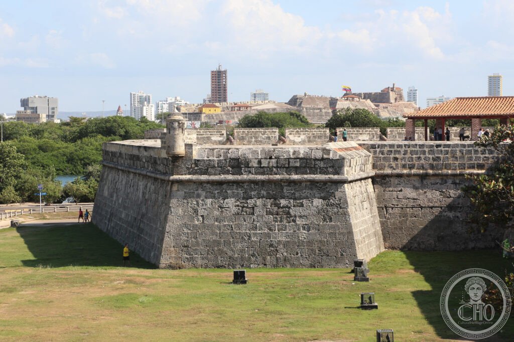
- The City Walls (Murallas de Cartagena): the most complete city walls in the Americas — a circuit of approximately 11 km of walls enclosing the old city (Ciudad Amurallada) and the Getsemaní neighbourhood; construction began in 1586 after Sir Francis Drake sacked the city and levelled approximately 200 of its buildings; the engineer Juan Bautista Antonelli designed the initial defences and the work continued under multiple engineers over two centuries; the walls are between 17 and 20 metres wide (wide enough for horse-drawn carriages to ride on the wall top) and 9–12 metres high, constructed of coral stone quarried from the sea floor of the Bay of Cartagena; the current circuit was completed in 1796; the baluartes (bastions) along the walls — the Bastería, the Baluarte de Santa Catalina — give the most dramatic views over the Caribbean and the bay
- Castillo de San Felipe de Barajas: the largest Spanish fort in the Americas — a vast fortress complex on the hill of San Lázaro (approximately 40 metres above the city, 1 km from the walled city centre) originally built between 1639 and 1657 and massively expanded in the 18th century; the fort sits on a network of underground tunnels (passageways for ammunition resupply and troop movements during siege conditions) that can be walked today; an attack by the British under Vice Admiral Edward Vernon and Major General Lord Cathcart in 1741 (the Battle of Cartagena de Indias — the largest British expeditionary force assembled before the Normandy landings: 186 ships and 23,600 men) was repulsed by the fort’s defenders under Blas de Lezo, who had only 6 ships and approximately 3,000 men; Vernon’s defeat was so total that he left before the fighting was over, writing premature dispatches of victory that had already been printed in London newspapers before the real outcome was known
- The Ciudad Amurallada (walled old city) and Getsemaní: the two main historic neighbourhoods; the Ciudad Amurallada (within the walls) contains the colonial city grid of the 16th–18th century, with the Plaza de los Coches, the Plaza de la Aduana, the Palacio de la Inquisición (the former tribunal of the Holy Inquisition, now a museum), the Cathedral of Cartagena (1575, rebuilt after Drake), and the Casa de Nariño; Getsemaní (the neighbourhood immediately outside the walls to the south of the San Diego gate) was historically the working-class and slave quarter of the city — less polished than the Ciudad Amurallada but increasingly the centre of the city’s contemporary art, food, and nightlife scene, with the Plaza de la Trinidad as its social heart
- The slave trade legacy and San Pedro Claver: Cartagena was the principal port of entry for enslaved Africans brought to New Granada (present-day Colombia and Venezuela); approximately 1 million Africans were imported through the city between 1533 and 1810; the Jesuit priest Pedro Claver (1580–1654, born in Catalonia) devoted 44 years of his life to the care of enslaved Africans arriving at the port, learning their languages, ministering to the sick and dying, and lobbying unsuccessfully against the institution of slavery; he was canonised in 1888 — the first person to be canonised in the New World; the Iglesia y Convento de San Pedro Claver (1603, rebuilt 1654) is the most visited church in Cartagena, with San Pedro Claver’s remains in the church; the Museo de Arte Moderno de Cartagena and the Arca del Gran Tesoro de Bolivia are in the complex
- Nobel literature connection: Gabriel García Márquez (1927–2014), the most important Latin American novelist of the 20th century, was born in Aracataca (90 km south-east of Cartagena) and spent much of his adult life in Cartagena; the city is the setting for his novel Love in the Time of Cholera (1985), one of the great novels of the 20th century, which transforms Cartagena’s colonial streets and bay into a feverish landscape of frustrated and requited love across 51 years; the novel has been the most powerful single driver of literary tourism to Cartagena; García Márquez’s house in the Manga neighbourhood and the streets and locations of the novel are marked by the city’s official tourism office
- Heritage: UNESCO World Heritage Site, Port, Fortresses and Group of Monuments of Cartagena, inscribed 1984
- GPS: 10.4231° N, 75.5519° W
History
Pedro de Heredia founded Cartagena de Indias on 1 June 1533 on a peninsula at the southern end of the Bay of Cartagena; the site had been occupied by the Turébé indigenous people; the Spanish quickly developed it into the primary port for the export of gold plundered from indigenous settlements in the interior (the looting of the Zenu culture produced enormous quantities of gold objects) and, from the 1540s, for the silver of the viceroyalties of New Granada and Peru. The city was sacked and partly destroyed by Francis Drake in 1586 (Drake demanded a ransom of 107,000 ducats, did not receive it all, and systematically demolished buildings for six weeks before leaving); the destruction triggered the decision to build the permanent defences that define the city today. The Spanish Empire spent approximately 68 million pesos (an enormous sum for the period) on the Cartagena defences between the 1580s and the 1790s.
The independence wars (1810–24) saw Cartagena declare independence from Spain in 1811 (one of the earliest declarations in Latin America, earning it the title “La Heroica”); the subsequent siege by royalist forces (1815–16, known as the “mortal siege” — approximately 6,000 of the city’s 18,000 inhabitants died of disease and starvation) was one of the bloodiest episodes of the independence wars; the city was liberated by Simón Bolívar in 1820; the Plaza de Bolívar (the main square) now bears his name and statue.
What you see
The walled old city (Ciudad Amurallada) is compact and walkable (approximately 1 km across); the main walk connects the Puerta del Reloj (Clock Gate, the primary ceremonial entrance to the walled city from the Getsemaní side) to the Plaza de los Coches (the square where slaves were sold in the colonial period) to the Plaza de la Aduana (the customs square, site of the original Palacio del Gobernador) to the Plaza de Santo Domingo (the city’s most atmospheric square, with the late-16th-century cathedral and the famous “Fat Botero” bronze sculpture by Fernando Botero in the corner) to the Palacio de la Inquisición (the Baroque palace of the Holy Office, 1770, one of the finest colonial palaces in South America). The walk along the top of the city walls at sunset (the Baluarte de Santo Domingo section gives the best light and the best views over the Caribbean) is the classic evening experience.
The Castillo San Felipe de Barajas (1.5 km from the walls, accessible by taxi or a 25-minute walk) is best visited separately in the early morning (before tour groups arrive); the underground tunnel system (guide required to access the deepest sections; guides at the entrance gate) takes 45–60 minutes to explore properly.
Practical information
- Admission: walled city and walls free; Castillo San Felipe de Barajas approximately COP 25,000 (about €5.50); Palacio de la Inquisición (now Museo Histórico de Cartagena) approximately COP 20,000 (about €4); Convento e Iglesia de San Pedro Claver approximately COP 15,000 (about €3.30); many colonial mansions now house restaurants and hotels with open courtyards that can be entered freely
- Getting there: Rafael Núñez International Airport (CTG) — direct international flights from Miami (American Airlines, 3.5h), Fort Lauderdale (Spirit, 3h), New York (American/JetBlue, 5h), Bogotá (multiple airlines, 55 min); from the airport to the historic centre: taxi approximately COP 25,000 (about €5.50, 20 minutes); bus (colectivo) approximately COP 2,500; Uber and Beat app available but subject to local restrictions
- Best season: December to April is the dry season on the Caribbean coast — the best period to visit (low humidity, minimal rain, trade winds cool the city); May to November has higher humidity and afternoon rain; December and January can be very crowded (high season from Colombia and North America); the Hay Festival Cartagena (January, international literary festival — one of the most important in Latin America) overlaps with the high season
Getting there
Rafael Núñez Airport (CTG): 20 min from old city, direct flights from Miami (3.5h), Bogotá (55 min). GPS: 10.4231, -75.5519.
Nearby
- Islas del Rosario (Rosario Islands) — 35 km south-west of Cartagena by boat (1 hour by lancha, 45 minutes by speedboat); a national marine park (Parque Nacional Natural Corales del Rosario y de San Bernardo) of 27 coral islands set in clear Caribbean water; the best snorkelling and diving accessible from Cartagena; the islands are reachable from the Muelle Turístico (tourist dock) at Cartagena’s Manga neighbourhood; day trips (approximately COP 80,000–120,000 including boat and lunch) depart at 8 am daily
- Barranquilla and the Caribbean road — 120 km north-east of Cartagena (1.5h by bus or car via the coastal highway); Colombia’s fourth largest city and the birthplace of Shakira and Gabriel García Márquez (the latter actually born in Aracataca, 90 km further south, but grew up in Barranquilla); the Carnaval de Barranquilla (February, UNESCO Intangible Cultural Heritage — the second largest Carnival in the world after Rio) is the primary reason to visit; the surrounding Cienaga Grande de Santa Marta (a vast lagoon system with mangrove forests and the flooded colonial village of Nueva Venecia, inhabited on stilts since the 18th century) is a world-class natural heritage site
- Mompox (Mompós) — 250 km south-east of Cartagena (4–5 hours by bus + ferry combination or 3h by private car); a perfectly preserved riverine colonial town on an island in the Magdalena River, declared a UNESCO World Heritage Site in 1995; Mompox was one of the most important colonial trading towns in New Granada (the silver coming from the Peruvian mines up the Magdalena River passed through here before going to Cartagena); the streets are unchanged since the colonial period; Gabriel García Márquez set the opening chapters of The General in His Labyrinth here; Mompox is the most atmospheric colonial heritage site in Colombia
Sources
- Wikipedia, Cartagena, Colombia; Castillo San Felipe de Barajas; Pedro Claver, accessed June 2026
- UNESCO, Port, Fortresses and Group of Monuments of Cartagena, WHS reference 285, inscribed 1984
- Roberto Arango, Las murallas de Cartagena de Indias, Lemoine Editores, 2009
- Gabriel García Márquez, El amor en los tiempos del cólera, Oveja Negra, 1985
Find it on the map
See this place and what’s around it →📷 Diventa un fotografo di Cultural Heritage Online
Condividi le tue foto dei luoghi: restano pubblicate con la tua firma come autore. Più vengono viste, più ti fai conoscere — e presto un concorso premierà le foto più apprezzate.
Accedi o registrati gratis per aggiungere una foto