Bayon and Angkor Thom
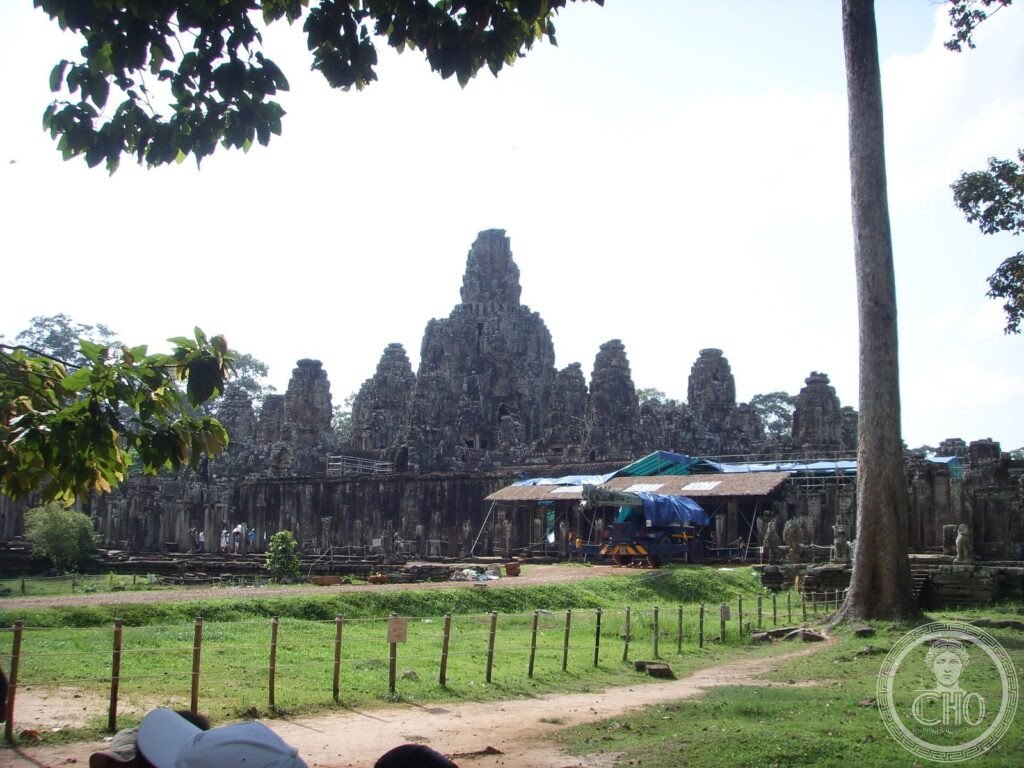
The last great state temple of the Khmer Empire — 54 stone towers bearing 216 giant faces carved at the height of Jayavarman VII’s power in the early 13th century, their half-closed eyes and faint archaic smiles staring out in all four cardinal directions simultaneously, an image of omniscient royal divinity more intimate and more unsettling than any other face in ancient Asian art.
At a glance
Angkor Thom (Khmer: អង្គរធំ, “Great City”) is the last and most enduring capital city of the Khmer Empire, constructed by King Jayavarman VII (r. 1181–1218 AD) on a square plan of approximately 9 sq km (3 km per side) in the Siem Reap Province of north-western Cambodia. The city was enclosed by a moat 100 metres wide and an 8-metre earthen rampart with stone facing; entry was through five stone gates, each topped by four giant faces. At the geographical and symbolic centre of the city stands the Bayon — the state temple of Jayavarman VII, a multistorey pyramid with 54 towers bearing 216 (originally perhaps 72×4=288) carved stone faces. The Angkor Thom complex, including the Bayon, is part of the UNESCO World Heritage Site Angkor, inscribed 1992, which also includes Angkor Wat and approximately 1,000 other temple sites in the Angkor Archaeological Park.
Key facts
- The faces of the Bayon: each of the 54 surviving towers has four faces (one facing each cardinal direction); the faces are 2.5–3.5 metres tall; the identity of the face is debated — the majority view is that it represents Jayavarman VII himself in the aspect of the bodhisattva Avalokitesvara (Lokesvara, the bodhisattva of compassion); the expression — calm, slightly smiling, with half-closed eyes — is known as the “Bayon smile” and appears throughout Khmer Buddhist art of the period
- The galleries of the Bayon: the outer and inner galleries of the Bayon have 1.2 km of bas-relief carvings; the outer gallery scenes are historical (battles against the Cham kingdom, daily life of the Khmer people, market scenes, cockfighting, fishing, childbirth); the inner gallery scenes are mythological (Hindu and Buddhist deities); the historical reliefs are the most important source for Khmer social history, depicting non-royal life in unprecedented detail
- Jayavarman VII (r. 1181–1218 AD): the most prolific builder in Khmer history; he constructed or restored 102 hospitals, 121 rest houses on the royal roads, and numerous temples; he converted the empire from Shaivism (worship of Shiva, the religion of the Angkor Wat builders) to Mahayana Buddhism; the Bayon and Ta Prohm are his most celebrated works; his face appears in numerous “portrait statues” of unusual psychological depth
- South Gate: the most elaborate of Angkor Thom’s five gates; a 23-metre tower bearing four faces flanked by stone balustrades representing the churning of the ocean of milk — 54 gods on the left holding the body of the serpent Vasuki, 54 demons on the right; the figures were heavily damaged in recent centuries; some heads are 20th-century reconstructions
- Terrace of the Elephants and Terrace of the Leper King: two structures on the Royal Square north of the Bayon; the Terrace of the Elephants has a 300-metre bas-relief frieze of elephants in procession that fronts the former review stand where the king watched processions; the Terrace of the Leper King has undercut galleries with multiple tiers of deities
- Heritage: UNESCO World Heritage Site, Angkor, inscribed 1992
- GPS: 13.4419° N, 103.8589° E
History
Angkor Thom was built after the catastrophic Cham sack of the Khmer capital in 1177 — the Cham fleet sailed up the Mekong and Tonlé Sap, defeated the Khmer navy, entered the city, and killed King Dharanindravarman II. Jayavarman VII, then a prince, rallied the Khmer forces and expelled the Cham in 1181. As king, he built Angkor Thom not only as a new capital but as a statement of permanent inviolability: the 8-metre ramparts, the 100-metre moat, the five fortified gates, and the city’s square plan (cosmologically representing Mount Meru at the centre of the universe) were designed to make the capital defensible against a repeat Cham attack and to assert Khmer sovereignty over the world.
The construction of the Bayon at the exact centre of the city, with its 216 faces staring in all directions simultaneously, was a statement of omnipresent royal power and Buddhist compassion: Jayavarman VII was the first Khmer king to rule under the bodhisattva ideal (the ruler who postpones his own enlightenment to serve all beings) rather than as a Hindu god-king (devaraja). His construction programme was the most intensive in Khmer history: the Ta Prohm temple, the Preah Khan temple, and dozens of other structures were built simultaneously, employing a workforce estimated in the hundreds of thousands.
After Jayavarman VII’s death c. 1218 AD, the Khmer Empire gradually declined over the next two centuries; the return to Shaivism under later kings led to systematic defacement of Buddhist imagery at the Bayon and other Jayavarman VII temples. Angkor Thom remained the Khmer capital until the 1430s, when the Siamese kingdom of Ayutthaya sacked the city and the Khmer court moved to Phnom Penh.
What you see
The approach to the Bayon from the South Gate is one of the great architectural processions in Asia: the causeway crosses the 100-metre moat between the rows of 54 gods and 54 demons (restored), the South Gate tower with its four massive faces rises ahead, and the interior of the city unfolds after the gate. The Bayon itself, 1 km north of the South Gate, reveals itself gradually: from a distance it appears as an indistinct mass of stone towers; as you approach, the faces emerge — one, then many, then, standing in the lower gallery, a simultaneous awareness of dozens of faces at different levels looking in different directions, the half-closed eyes at approximately head height, the faint smile unchanging regardless of the light or your angle.
The upper platform (reached by staircase from any of the four cardinal directions) gives access to the face towers at close range; the faces are 2.5–3.5 metres tall and the detail — the hair, the eyebrows, the lips, the expression — is clearest in the late afternoon light when low sun rakes across the stone. The outer gallery bas-reliefs (east and south galleries are the most interesting) require time and patience to read; a good guide is invaluable for interpreting the historical scenes.
Practical information
- Angkor pass: the Angkor Archaeological Park has a ticket system: 1-day pass $37, 3-day pass $62, 7-day pass $72; the pass covers all sites including the Bayon, Angkor Wat, Ta Prohm, Preah Khan, and all other temples in the park; sold at the main ticket office on the road from Siem Reap
- Getting there: from Siem Reap town centre, the South Gate of Angkor Thom is approximately 8 km by tuk-tuk (20 minutes, $10–15 round trip) or bicycle (40 minutes; bicycle hire USD 2–5 per day); the Bayon is 1 km north of the South Gate within the city walls
- When to visit: sunrise at Angkor Wat (5 km south-east of the Bayon) is the classic experience; the Bayon itself is more atmospheric in the late afternoon when the low light reveals the facial details; it is most crowded between 8 and 11 am; arrive at 6:30–7 am or after 3 pm for the best experience
- Dress code: knees and shoulders must be covered; sarongs available at temple entrances
Getting there
Siem Reap International Airport (REP) has direct flights from Bangkok, Singapore, Kuala Lumpur, Ho Chi Minh City, Phnom Penh, and other regional hubs. From Siem Reap town centre, tuk-tuk or bicycle to Angkor Thom South Gate (8 km, 20 minutes). GPS: 13.4419, 103.8589.
Nearby
- Angkor Wat — 5 km south-east of the Bayon; the largest religious monument in the world (162.6 hectares); built c. 1113–1150 AD by Suryavarman II; dedicated to Vishnu; the most visited heritage site in Southeast Asia; sunrise over the reflecting pools is Cambodia’s most-photographed image
- Ta Prohm — 1 km east of the Bayon; a Jayavarman VII temple left partially unrestored, with large silk-cotton tree roots growing over the stone structures; the “jungle temple” aesthetic made famous by the Tomb Raider films; 2 km from the South Gate of Angkor Thom
- Preah Khan — 3 km north-east of Angkor Thom; a large Jayavarman VII temple with a two-storey structure and long colonnaded galleries; less visited than the Bayon or Ta Prohm; the Hall of Dancers (carved apsara friezes) and the two-storey “house of fire” are the highlights
Sources
- Wikipedia, Bayon; Angkor Thom, accessed June 2026
- UNESCO, Angkor, WHS reference 668, inscribed 1992
- David Chandler, A History of Cambodia, 4th ed., Westview Press, 2008
- Vittorio Roveda, Khmer Mythology: Secrets of Angkor, Weatherhill, 1997 — the standard reference on the iconography of the bas-reliefs
Find it on the map
See this place and what’s around it →📷 Diventa un fotografo di Cultural Heritage Online
Condividi le tue foto dei luoghi: restano pubblicate con la tua firma come autore. Più vengono viste, più ti fai conoscere — e presto un concorso premierà le foto più apprezzate.
Accedi o registrati gratis per aggiungere una foto