Angkor Wat — Siem Reap
The largest religious monument on earth — 1.6 km of bas-relief galleries enclosing a temple mountain with five towers aligned to represent Mount Meru, built by a Khmer king for the god Vishnu in the first half of the 12th century, later converted to Buddhism.
At a glance
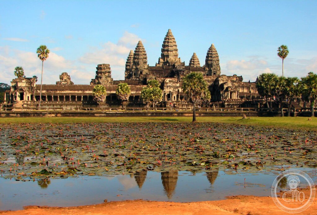
Angkor Wat stands 5 kilometres north of Siem Reap in north-western Cambodia, its five lotus-shaped towers rising above a moat 190 metres wide and 5.4 kilometres in circumference — the largest moat surrounding any religious monument in the world. The temple was built by the Khmer emperor Suryavarman II (r. c. 1113–1150) as his state temple and royal mausoleum, dedicated to the Hindu god Vishnu. Its name means “City Temple” in Khmer. The complex covers 402 acres (162.6 hectares); at the time of its construction it was the largest city on earth, housing a population estimated at up to one million people in the greater metropolitan area of Angkor. Angkor Wat is unique among the Angkor temples in being oriented toward the west — the direction of the setting sun and of death in Hindu cosmology, reinforcing its funerary character. It was inscribed as a UNESCO World Heritage Site as part of Angkor in 1992.
Key facts
- Builder: Suryavarman II (r. c. 1113–1150); architect unknown; construction c. 1113–1150 AD
- Size: 402 acres (162.6 hectares); five towers (the tallest reaches 65 metres); moat 190 m wide, 5.4 km in circumference
- Bas-relief galleries: approximately 1.6 kilometres of continuous bas-relief at ground level; the largest bas-relief complex in the world; subjects include the Churning of the Ocean of Milk, the Battle of Kurukshetra, scenes from the Mahabharata and Ramayana
- Stone: approximately 5–10 million sandstone blocks, most quarried from the Kulen Hills 50 km north and floated down the Siem Reap River; no mortar used — the blocks fit dry
- Religion: originally Hindu (Vishnu); converted to Theravada Buddhism by the 14th century; continues as a functioning Buddhist monastery today
- Heritage: UNESCO World Heritage Site, Angkor, inscribed 1992
- GPS: 13.4125° N, 103.8670° E
History
The Khmer Empire, founded in the early 9th century, established its capital at Angkor in the late 9th century. By the time of Suryavarman II, who unified the empire by conquest, it was already the most powerful state in mainland South-East Asia, controlling territory corresponding approximately to modern Cambodia, Laos, Thailand, and southern Vietnam. The decision to build Angkor Wat — a state temple aligned with Vishnu, the creator god, rather than Shiva, whom earlier Khmer rulers had favoured — may reflect Suryavarman’s personal devotion or a deliberate political choice. The scale of the undertaking suggests a decade or more of continuous construction; Suryavarman died before its completion.
The complex remained a functioning Hindu temple under subsequent rulers, who made additions and alterations. The conversion to Theravada Buddhism, which began spreading through the region from the 13th century, was gradual; by the 14th or 15th century, Angkor Wat had become a Buddhist monastery and remains one today. When European visitors — Portuguese in the 16th century, followed by the French in the 19th — encountered the ruins, it was still an active religious site, never fully abandoned as the neighbouring temples of Angkor Thom had been. The French naturalist Henri Mouhot’s account of his 1860 visit brought Angkor to widespread European attention and initiated the long process of Western archaeological investigation.
The Cambodian Civil War (1967–1975) and the subsequent Khmer Rouge regime (1975–1979) severely damaged Angkor’s cultural infrastructure, though the temples themselves survived largely intact — the isolation of the country protected them from large-scale looting until the Vietnamese occupation of 1979 brought relative stability. Since the 1990s, international conservation teams from France (EFEO), India, Germany, Japan, and the United States have worked alongside the Cambodian APSARA Authority on ongoing restoration and consolidation. Tourism has grown from a few thousand visitors in the 1990s to over 2.6 million before the COVID-19 pandemic of 2020.
What you see
The approach from the west crosses the 190-metre moat on a stone causeway 250 metres long, flanked by naga (serpent deity) balustrades. The western gopura (gateway pavilion) is the first of several nested enclosures; each enclosure is raised slightly above the one outside it, the entire complex organised as a stepped pyramid — the “temple mountain” (prasat) representing the sacred Mount Meru, home of the gods. The five towers represent the five peaks of Meru; the moat, the cosmic ocean.
The third enclosure — at ground level — carries the famous bas-relief galleries: 800 metres of continuous carved panels on the inner walls, typically 2 metres high, depicting scenes from Hindu epics and from Suryavarman’s military campaigns. The carving quality varies from panel to panel (the south gallery’s Battle of Kurukshetra is the finest), but the sheer scale — 1.6 kilometres without interruption — has no parallel in world architecture. At the centre, the tower sanctuary is accessible by an extremely steep staircase. Sunrise, when the five towers are reflected in the western pool, is the image most associated with Angkor Wat and worth the 4:30 am departure from Siem Reap.
Practical information
- Tickets: sold only at the Angkor Enterprise ticket office on the road to Angkor (not at the temple); 1-day USD 37, 3-day USD 62, 7-day USD 72; no online purchase — cash or card at the counter
- Hours: Angkor Wat specifically 5 am–5:30 pm (to allow sunrise entry); other temples 7:30 am–5:30 pm
- Sunrise: arrive at the west entrance by 5 am; the reflecting pool on the left path offers the iconic view; busiest period is 5:30–6:30 am
- Dress code: shoulders and knees must be covered to enter (rules enforced); temples are active religious sites
- Getting around: tuk-tuk is the standard mode; negotiate the day’s circuit with the driver the evening before; bicycles available for small circuit (15 km); e-bikes increasingly popular
Getting there
Siem Reap International Airport is 8 km from the temples; direct flights from Bangkok, Singapore, Kuala Lumpur, Ho Chi Minh City, and major Chinese cities. The temples are 5–8 km from Siem Reap town; tuk-tuk or car hire from any hotel. GPS to Angkor Wat main entrance: 13.4125, 103.8670.
Nearby
- Angkor Thom & Bayon — the walled capital city of Jayavarman VII (late 12th–early 13th century), 2 km north; the Bayon temple has 216 carved stone faces peering from 54 towers
- Ta Prohm — the temple left intentionally unrestored, with giant trees growing through the stone walls; used as a filming location for Lara Croft: Tomb Raider
- Preah Khan — a large flat temple complex, 10th–12th century, less visited than Angkor Wat or Bayon; excellent bas-reliefs in a more intimate scale
- Tonle Sap Lake — South-East Asia’s largest freshwater lake, 10 km south of Siem Reap; floating villages and extraordinary seasonal flooding; integral to the ecology that made Angkor possible
Sources
- Wikipedia, Angkor Wat, accessed June 2026
- Official APSARA Authority: autoriteapsara.org
- UNESCO, Angkor, WHS reference 668, inscribed 1992
- Eleanor Mannikka, Angkor Wat: Time, Space, and Kingship, University of Hawaii Press, 1996
Find it on the map
See this place and what’s around it →📷 Diventa un fotografo di Cultural Heritage Online
Condividi le tue foto dei luoghi: restano pubblicate con la tua firma come autore. Più vengono viste, più ti fai conoscere — e presto un concorso premierà le foto più apprezzate.
Accedi o registrati gratis per aggiungere una foto