
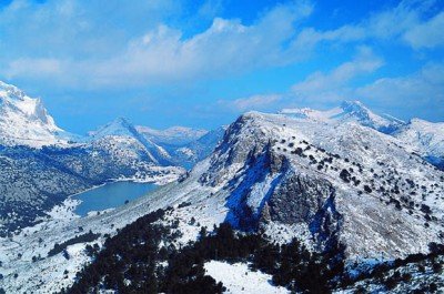
A thousand years of human ingenuity carved into the rugged north-western spine of Mallorca: Moorish terraces, Mallorcan manor estates, the island’s only river, and two of Europe’s most storied artistic retreats.
At a glance
The Serra de Tramuntana is the mountain range running the full 90-kilometre north-west length of the island of Mallorca, Spain. Its peaks reach 1,436 metres at Puig Major — the highest point in the Balearic Islands — and its north face drops precipitously into the Mediterranean. UNESCO inscribed it as a Cultural Landscape in 2011, recognising over 1,000 years of continuous human adaptation to one of the most challenging agricultural environments in the western Mediterranean: steep slopes, thin soils, and chronic water scarcity. The result is an extraordinary man-made landscape of dry-stone terraces, Moorish irrigation channels, water mills, and noble manor estates that together transformed an inhospitable mountain range into the productive heart of Mallorca’s historic agriculture.
Key facts
- UNESCO inscription: 2011 (Cultural Landscape)
- Location: North-western Mallorca, Balearic Islands, Spain
- Extent: 30,745 hectares inscribed (the range runs approximately 90 km)
- Highest peak: Puig Major, 1,436 m (military restricted area)
- Key period: 10th century CE (Moorish) to present
- Only river in Mallorca: Torrent de Pareis (seasonal)
- Key settlements: Valldemossa, Deià, Sóller, Pollença, Fornalutx
History
Before the Arab conquest of Mallorca (902 CE), the Serra de Tramuntana was sparsely settled scrubland. It was the Moorish farmers and hydraulic engineers who, between the 10th and 13th centuries CE, fundamentally transformed the landscape. They designed and built a sophisticated network of dry-stone terraces (marjades) to create flat agricultural surfaces on near-vertical slopes, and an equally sophisticated irrigation system: stone channels (siquies) captured rainfall and spring water, distributing it through the terraces to fields growing olives, almonds, citrus, and vegetables. The hydraulic knowledge required was extraordinary — rivalling the qanat systems of the Middle East and North Africa from which it descended.
After the Christian Reconquest of Mallorca by King Jaume I of Aragon in 1229 CE, the landscape underwent a social transformation. Moorish farmers were expelled or converted, and the land was distributed among the Catalan and Aragonese nobility. The new lords built large manor estates (possessions) throughout the Serra — fortified complexes with defensive towers, formal gardens, olive presses, and extensive enclosed agricultural lands. Many of these possessions survive as working farms or converted hotels. The Moorish hydraulic and terrace infrastructure, however, was preserved and continued in use — its practical value transcended the political change.
From the 19th century, the Serra attracted artists and writers. The composer Frédéric Chopin and the writer George Sand famously wintered in the Carthusian monastery of Valldemossa in 1838–39 (an experience Sand described in Un hiver à Majorque). The poet and novelist Robert Graves settled in Deià in 1929 and lived there for most of the rest of his life, drawing an artistic and literary circle that made the village internationally known.
What you see
The dominant visual feature is the terrace network: kilometre after kilometre of dry-stone walls (built without mortar) stepping up the mountain slopes, still cultivated with gnarled centuries-old olive trees. The walls are a masterclass in vernacular engineering — each one precisely levelled, built from local limestone, and designed to retain soil and channel rainwater simultaneously.
The Moorish water system is still visible in the form of stone channels running along contour lines through the terraces, small stone cisterns at intervals, and working water mills (molins) in the valleys. Several are open to visitors. The possessions — manor estates — are recognisable by their large fortified towers (torres de defensa), ornate stone gateways, and formal kitchen gardens. The village of Deià sits on a terrace above the sea with characteristic vernacular stone houses. The Torrent de Pareis gorge, near Sa Calobra, is one of the most dramatic ravines in the Mediterranean and can be hiked on foot.
Practical information
- Access: By car via the MA-10 corniche road (Andratx to Pollença), one of the great scenic drives in Europe; by bus from Palma to Sóller/Valldemossa; ferry + train from Palma to Sóller (historic vintage train)
- Best base: Sóller (train access, central position) or Valldemossa (historic center)
- Must see: Valldemossa Carthusian Monastery (Chopin cells); Deià village and Robert Graves Museum; Sa Calobra and Torrent de Pareis gorge; Fornalutx village
- Hiking: GR221 (Ruta de Pedra en Sec / Dry Stone Route) runs the full length of the Serra — 167 km, 8 stages, refuges available
- Season: March–May and September–November are ideal; summer is very hot and extremely crowded
Getting there
Palma de Mallorca Airport (PMI) connects to most European capitals. From Palma, the Serra is 15–45 minutes by car depending on destination. The Palma–Sóller Railway (1912) is a heritage attraction in itself — a narrow-gauge train through mountain tunnels and orange groves that connects Palma to the Sóller valley in about 50 minutes. From Sóller, the vintage tram descends to the Port de Sóller. Car rental from Palma is the most flexible option for exploring the range.
Nearby
The Prehistoric Rock Art of the Mediterranean Basin (partially on Mallorca) and the historic Old Town of Alcúdia are within day-trip distance. The Caves of Artà and Drach (eastern Mallorca) offer dramatic karstic landscapes. The Route of the Dry Stone Villages — Deià, Fornalutx, Biniaraix — can be walked in a single day from Sóller.
Sources
- UNESCO World Heritage Centre — Cultural Landscape of the Serra de Tramuntana (whc.unesco.org)
- Consell de Mallorca — Serra de Tramuntana documentation
- George Sand, Un hiver à Majorque, 1842
- Wikipedia — Serra de Tramuntana
Find it on the map
See this place and what’s around it →📷 Become a Cultural Heritage Online photographer
Share your photos of places: they stay published under your name as the author. The more they're seen, the more you get noticed — and soon a contest will reward the most appreciated photos.
Log in or sign up free to add a photo