Derbent — Gateway of the Caucasus
Russia’s oldest continuously inhabited city and guardian of the Caspian Gates, Derbent has stood at the bottleneck between the Caucasus Mountains and the Caspian Sea for seven thousand years. Its Sassanid Persian fortification walls — stretching unbroken from the mountain ridge to the sea — earned UNESCO World Heritage status in 2003.
At a glance
Derbent occupies a three-kilometre-wide corridor — historically the only practical land route between the steppe world of the north and the civilised lands of the Middle East — where the Greater Caucasus Mountains descend almost to the Caspian shoreline. The city’s Sassanid fortifications: the hilltop citadel of Naryn-Kala, the twin parallel walls descending through the town, and the sea barrier extending into the Caspian itself, form the most complete surviving ancient defensive system in the Caucasus. With approximately 5,000 years of continuous human settlement, Derbent is classified as the oldest city in Russia and one of the oldest continuously inhabited cities in the world.
Key facts
- UNESCO WHS: 2003 (Ancient City of Derbent — Citadel, Ancient City and Fortress Buildings)
- Oldest city in Russia: Continuously inhabited since approximately 5000 BCE
- Strategic pass: Caspian Gates — 3 km corridor between the Caucasus range and the Caspian Sea
- Citadel: Naryn-Kala, Sassanid construction 5th–6th century CE, area c. 4.5 hectares
- Walls (sadd): Twin parallel walls 3.6 km long, 3 m thick, up to 10 m high, with 73 towers
- Roman inscription: Latin stone carving records XII Fulminata legion presence, c. 75 CE — the southernmost attested Roman military presence on the Caspian
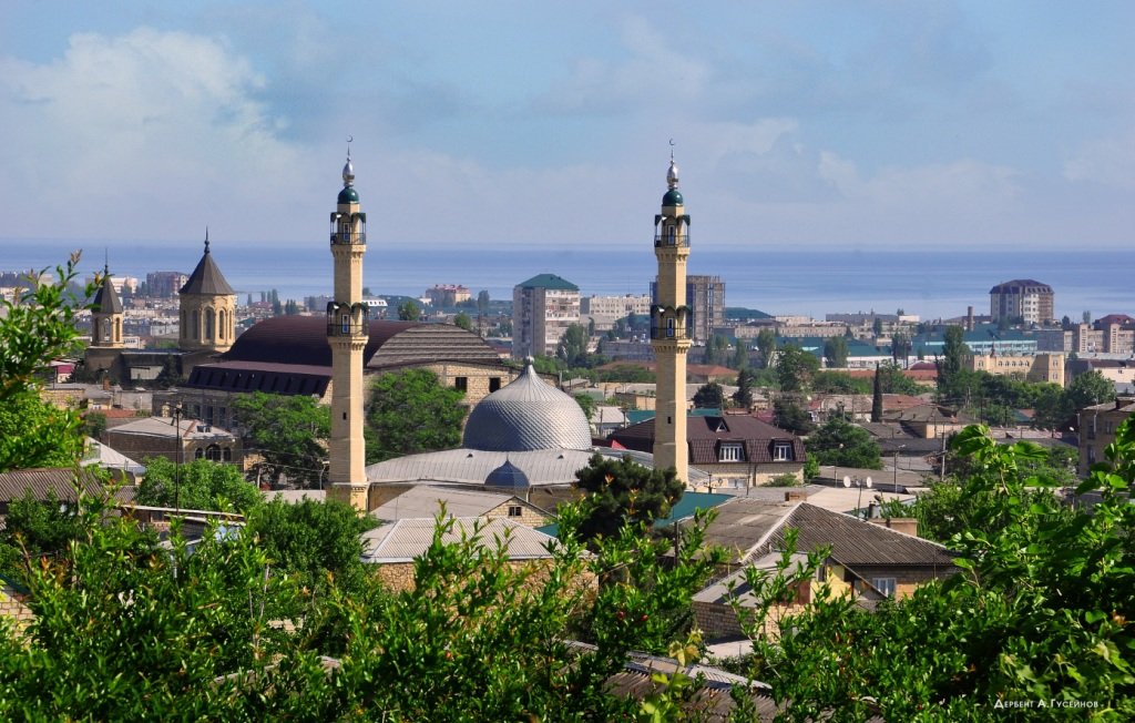
- Juma Mosque: Oldest mosque in Russia, 8th century CE, built on an earlier Christian basilica
- Coordinates: 42.0620° N, 48.2740° E
History
Evidence of Bronze Age occupation at the Derbent site dates to approximately 3500–4000 BCE. The city’s strategic position at the Caspian Gates made it coveted by every regional empire: it features in the accounts of Alexander’s successors and Pompey’s eastern campaign (66–65 BCE). A Latin inscription discovered at the site, recording the presence of the Roman XII Fulminata legion around 75 CE, provides proof that Roman power reached as far as the Caspian coast.
The monumental fortification system visible today was the work of the Sassanid Persian emperor Khosrow I (reigned 531–579 CE). The twin parallel walls, each 3.6 kilometres long with 73 towers and four gated passages, channelled all traffic through controlled entry points while Naryn-Kala on the ridge above surveyed the entire pass. A sea wall (Dag Bary) extended into the Caspian to prevent coastal bypass.
Arab forces captured Derbent in 642–643 CE and made it an important centre for the northward spread of Islam. The 10th-century geographer al-Masudi described a city where seventy-two languages were spoken — testimony to its role as a cosmopolitan frontier entrepôt. Russian forces under Peter the Great took the city in 1722; it passed definitively into the Russian Empire under the Treaty of Gulistan in 1813.
What you see
The Naryn-Kala citadel crowns the ridge at roughly 110 metres elevation: an irregular trapezoid of massive ashlar masonry enclosing a palace complex, underground cisterns storing over 2,000 m³ of water, a triple-conversion church (Christian basilica, then mosque, then Russian Orthodox church), bathhouses, and administrative buildings. Below, the twin sadd walls descend steeply through the historic city fabric to the shore, surviving at original height in many sections. Between the walls, the Old City (Staryy Gorod) preserves narrow bazaar streets, the Juma Mosque (Russia’s oldest, 8th century CE), and a 15th-century caravanserai. The sea barrier is largely submerged but its line is traceable from the beach.
Practical information
- Open: Naryn-Kala citadel daily, approximately 09:00–18:00 (seasonal variation)
- Admission: Combined ticket for citadel and museum; walls and Old City streets free
- Museum: Derbent History, Architecture and Art Museum-Reserve inside the citadel
- Language: Russian; some Azerbaijani and Lezgian; limited English
- Best season: May–June and September–October
- Travel note: Russian visas required for most nationalities; verify current advisories before travel
Getting there
Derbent lies on the M29/E119 coastal highway and railway linking Makhachkala (130 km north, approx. 2.5 hours by train) with Baku, Azerbaijan (180 km south). Marshrutka shared minibuses run from Makhachkala bus station (1.5–2 hours). The nearest airport is Uytash Airport, Makhachkala (IATA: MCX), with flights to Moscow and major Russian cities.
Nearby
- Gobustan Rock Art (Azerbaijan) — approx. 190 km south; UNESCO WHS 2007, 6,000 petroglyphs from 40,000 BCE
- Baku Old City (Icheri Sheher) — approx. 180 km south; UNESCO WHS 2000
- Makhachkala — Dagestani capital, 130 km north; transport hub
- Kubachi — highland village celebrated for its master silversmiths since the medieval period, approx. 140 km northwest
Sources
- UNESCO World Heritage List — Ancient City of Derbent (WHS 1070)
- Wikipedia — Derbent
- Encyclopaedia Iranica — Darband (Sassanid fortifications)
Find it on the map
See this place and what’s around it →📷 Diventa un fotografo di Cultural Heritage Online
Condividi le tue foto dei luoghi: restano pubblicate con la tua firma come autore. Più vengono viste, più ti fai conoscere — e presto un concorso premierà le foto più apprezzate.
Accedi o registrati gratis per aggiungere una foto