Caracol
The Maya city that defeated Tikal: in 562 AD, Caracol crushed its great rival in a Star War and sent Tikal into a 130-year political silence — one of the most dramatic reversals in ancient American history.
At a glance
Caracol lies in the remote Maya Mountains of western Belize at approximately 500 metres elevation, reached by a long dirt road through the Chiquibul Forest Reserve. At its Late Classic peak (c. 650-900 AD), it covered approximately 177 km2 and housed an estimated 115,000-150,000 people — the largest city in the history of Belize. Its ancient name was Oxwitza (Three Hills Water Place). Today it is dominated by the Caana palace-pyramid — at 43 metres, the tallest standing structure in Belize.
Key facts
- Period: c. 300 BC-900 AD (Pre-Classic to Terminal Classic Maya)
- Ancient name: Oxwitza (Three Hills Water Place)
- Peak population: c. 115,000-150,000 (Late Classic)
- Area: approx. 177 km2 mapped archaeological features
- Caana height: 43 m — tallest structure in Belize
- 562 AD Star War: Caracol defeats Tikal; Tikal enters 130-year monument hiatus
- Causeways: approx. 100 km of sacbeob — most extensive network at any Maya city
History
Caracol was established in the Pre-Classic period and grew steadily through the early Classic era as a secondary centre in the Maya lowlands. Its moment of world-historical significance came on 562 AD — a date recorded on its own monuments as a Star War, meaning a military attack coordinated with the heliacal rising of Venus. Acting as a client or ally of Calakmul, Caracol attacked Tikal, captured its king Wak Chan Kawiil and had him sacrificed. Tikal erected no dated monuments for the next 130 years, its trade network collapsed, and its political influence evaporated from the regional record — the longest political interruption of any major Classic Maya city.
Empowered by its defeat of Tikal, Caracol spent the following century in architectural expansion. The Caana palace complex was built and enlarged to its final height of 43 metres — a massive four-tiered palace-pyramid containing multiple vaulted chambers and royal tomb deposits. The city agricultural hinterland was connected to the urban core by approximately 100 km of raised causeways.
Caracol began declining in the late eighth century. Its last dated monument is from 859 AD; by 900 AD the site was largely abandoned. The name Caracol — Spanish for snail or spiral shell — was given in 1937 because of the winding road that led the first archaeologist to the site. Systematic excavation began only in 1985 under Arlen and Diane Chase of the University of Central Florida.
What you see
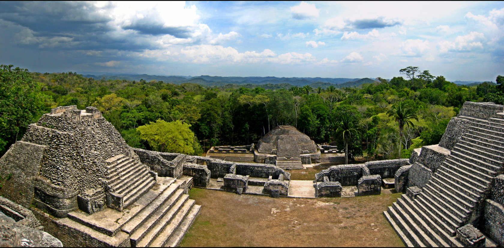
The site centrepiece is Caana — the Sky Place — a four-tiered palace-pyramid rising 43 metres with three temples on its summit platform and a network of vaulted rooms within its upper levels. It is the tallest standing man-made structure in Belize; climbing it gives panoramic views over the Chiquibul Forest canopy. Within its excavated chambers archaeologists have found elite burials with jade masks, ceramics, and obsidian bloodletting tools.
Six major sacbeob (raised causeways) radiate outward from the city centre to satellite settlements and the agricultural terracing system; parts of several causeways remain walkable. The mountain setting at 500 metres gives Caracol a different atmospheric quality from the lowland Maya sites: the forest is cooler and denser, and the long drive through the Chiquibul Reserve is part of the experience.
Practical information
- Opening hours: Daily 8:00-16:00
- Admission: BZD 15 (approx. USD 7.50) for foreign visitors
- Access road: Unpaved; high-clearance vehicle required (4WD strongly recommended in wet season)
- Guided tours: Available from San Ignacio (approx. 50 km)
- Best time to visit: February-May (dry season)
- On-site: Small visitor centre and caretaker guides; no restaurant — bring food and water
Getting there
Caracol is approximately 50 km south of San Ignacio (Cayo District) via the Chiquibul Road — a journey of 1.5-2 hours on unpaved roads. The road passes through Augustine and crosses several streams. Self-driving is possible in a high-clearance 4WD vehicle; day tours from San Ignacio are the most practical option. There is no public transport to the site.
Nearby
- Xunantunich — approx. 45 km north near San Ignacio; Classic Maya city with El Castillo pyramid (approx. 40 m), accessible by hand-cranked ferry
- Mountain Pine Ridge Forest Reserve — en route to Caracol; Hidden Valley Falls (305 m), Rio On Pools, Rio Frio Cave
- San Ignacio — main base town for western Belize, approx. 50 km; full tourist infrastructure, Cahal Pech ruin within town
Sources
- Chase, A.F. and Chase, D.Z. (1987). Investigations at the Classic Maya City of Caracol, Belize. Pre-Columbian Art Research Institute.
- Martin, S. and Grube, N. (2008). Chronicle of the Maya Kings and Queens. Thames and Hudson.
- Belize Institute of Archaeology: nicmbelize.org
- Wikipedia: Caracol
Find it on the map
See this place and what’s around it →📷 Diventa un fotografo di Cultural Heritage Online
Condividi le tue foto dei luoghi: restano pubblicate con la tua firma come autore. Più vengono viste, più ti fai conoscere — e presto un concorso premierà le foto più apprezzate.
Accedi o registrati gratis per aggiungere una foto