Caral
The oldest known urban centre in the Americas — a planned city of monumental platform mounds and sunken circular plazas built in the Supe Valley around 2600 BC, at the exact moment the Egyptians were raising the Giza Pyramids five thousand kilometres away.
At a glance
Caral is the principal site of the Norte Chico civilisation, an entirely unknown culture that constructed at least 30 urban centres along the river valleys of the Peruvian coastal desert between approximately 3000 and 1800 BC. The site covers 66 hectares and comprises six large platform mounds (the tallest rising 18 metres above the valley floor), three sunken circular plazas used for communal ceremony and acoustic performance, residential compounds of varying social rank, and an irrigation infrastructure that channelled river water to fields 10 kilometres away. No pottery, no evidence of warfare, no weapons, no fortifications: Caral was a city organised by commerce and ritual rather than conquest. Its discovery upended the longstanding assumption that complex urban civilisation in the Americas began with the maize-based cultures of Mesoamerica several centuries later.
Key facts
- Period: c. 3000–1800 BC (Norte Chico / Caral-Supe civilisation); radiocarbon dates at 2627 BC confirmed by multiple laboratories
- UNESCO inscription: 2009 (Sacred City of Caral-Supe)
- Scale: 66 hectares; six major platform mounds; largest pyramid (Mayor Pyramid) 160 m × 150 m × 18 m high
- Location: Supe Valley, Barranca Province, 200 km north of Lima; 10 km from the Pacific Ocean
- Key excavator: Ruth Shady Solís, National University of San Marcos, from 1994 onward
- Access: Open to visitors; entry via guided tour; site is active archaeological excavation
History
Caral was first noted in the archaeological literature in the 1940s and 1970s, but its enormous earthen mounds were dismissed by most researchers as natural hills, and a lack of ceramics led early surveyors to assign it a late or minor date. The systematic excavations begun in 1994 by Ruth Shady Solís of the National University of San Marcos changed everything. Shady recovered organic material — woven rush bags (shicras) used to carry fill material during construction — whose radiocarbon dates, when confirmed by the laboratories of Jonathan Haas at the Field Museum in Chicago and Winifred Creamer at Northern Illinois University in 2001, produced dates clustering around 2627 BC. This placed Caral squarely in the same historical moment as the Old Kingdom of Egypt (the Giza Pyramid complex was built c. 2560–2540 BC) and Sumerian Ur, transforming the understanding of the parallel development of complex societies worldwide.
The Norte Chico civilisation that built Caral and its sister cities operated on a singular economic logic. The coastal communities fished anchovies in vast quantities — the same anchovy fishery that sustains Peru’s modern fishing industry — and traded dried fish inland to the river valley settlements of Caral in exchange for cotton and other agricultural products. Cotton was the critical commodity: it was woven into fishing nets, which enabled more fish, which enabled more cotton. This coastal-inland exchange network, not the cultivation of maize or other grains, appears to have been the engine that generated sufficient surplus to support a non-farming specialist class capable of engineering and constructing monumental architecture. Caral had no grain storage; its economy was maritime before it was agricultural.
The city appears to have been abandoned gradually rather than violently around 1800 BC, possibly due to climate change (evidence of El Niño-driven flooding and drought in the region) or a shift in trade routes. Unlike Mohenjo-daro or the later Mesoamerican cities, Caral shows no evidence of having been destroyed or conquered. UNESCO inscribed the site as a World Heritage property in 2009 under the name “Sacred City of Caral-Supe,” recognising it as “the oldest centre of civilisation in the Americas and one of the earliest in the world.”
What you see
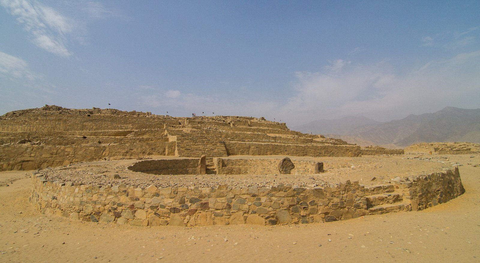
Standing at the base of the Mayor Pyramid — 160 metres wide, 150 metres deep, 18 metres high — the scale registers not through a single dramatic form (as with a pyramid at Giza) but through the accumulated mass of millions of individual shicra bags of fill material, visible in cross-section where excavation has exposed the construction method. Each bag was woven from rush, filled with rubble and sand, placed in position, and the bag was left to decompose within the fill. The result is a mound of extraordinary structural stability, built in stages over centuries. Atop the Mayor Pyramid, a rectangular ceremonial chamber with a central firepit was used for controlled burning — most likely as part of atmospheric ritual, the smoke visible across the valley from kilometres away.
The sunken circular plazas — three of them, positioned in front of the major platform mounds — are among the most architecturally distinctive features of the Caral cultural tradition. Roughly 50 metres in diameter, recessed 1–2 metres below the surrounding ground level, their circular geometry creates a natural acoustic shell: a speaker or musician at the centre can be heard clearly around the entire circumference without amplification. The 32 flutes made from condor and pelican bones recovered from a buried cache at Caral confirm the importance of music in ritual life. The combination of the plaza’s acoustic geometry and wind instruments capable of producing complex harmonics suggests these were spaces designed not merely for assembly but for choreographed sonic performance.
Practical information
- Opening hours: Tuesday–Sunday, 09:00–17:00; the site is active, so some areas may be temporarily closed during excavation
- Best season: May–October (dry season); the coastal desert climate makes year-round visits feasible, but summer (January–March) can bring El Niño-related cloud and occasional rain
- Booking: Tickets purchased on-site; entry as part of guided tour groups; independent wandering of excavation areas is not permitted
- Duration: Guided tour approximately 90–120 minutes
- Admission: Nominal entry fee; check current rates with the Zona Arqueológica Caral (ZAC) authority
Getting there
The nearest major airport is Jorge Chávez International Airport in Lima (LIM), approximately 200 km south. From Lima, the Panamericana Norte highway runs directly to Barranca, the nearest town of size (approximately 3 hours by bus or car). From Barranca, the site is reached via a secondary road up the Supe Valley — approximately 25 km; a taxi or organised tour from Barranca or from Lima is the most practical option. Several Lima-based tour operators offer day trips or overnight excursions to Caral. The last stretch of road is unpaved and requires a vehicle with reasonable clearance, particularly after seasonal rains.
Nearby
- Áspero — coastal Norte Chico site at the mouth of the Supe River, 10 km from Caral; the maritime counterpart to Caral’s inland complex
- Bandurria — another Norte Chico site near Huacho, approximately 60 km south of Caral, with sunken circular plazas
- Chan Chan — later adobe capital of the Chimú Empire, 600 km north; UNESCO World Heritage Site; contrasting model of conquered urban civilisation
- Pachacamac — major Inca-period sacred site south of Lima, accessible as a half-day trip from the capital
Sources
- Wikipedia: Caral-Supe
- UNESCO World Heritage Centre: Sacred City of Caral-Supe — whc.unesco.org/en/list/1269
- Zona Arqueológica Caral (ZAC): zonacaral.gob.pe
- Shady Solís, R., Haas, J., & Creamer, W. (2001). “Dating Caral, a Preceramic Site in the Supe Valley on the Central Coast of Peru.” Science 292(5517): 723–726.
Find it on the map
See this place and what’s around it →📷 Diventa un fotografo di Cultural Heritage Online
Condividi le tue foto dei luoghi: restano pubblicate con la tua firma come autore. Più vengono viste, più ti fai conoscere — e presto un concorso premierà le foto più apprezzate.
Accedi o registrati gratis per aggiungere una foto