Tiwanaku
At 3,840 metres above sea level on the Bolivian altiplano, the capital of the Tiwanaku Empire shaped the Andean world for a millennium – and the Gateway of the Sun, cut from a single 10-tonne block of andesite, gave the Inca civilisation its most sacred deity.
At a glance
Tiwanaku (also spelled Tiahuanaco) was the capital of one of the most influential pre-Columbian civilisations in South America, flourishing between approximately 300 BC and 1000 AD with its peak between 500 and 900 AD. A UNESCO World Heritage Site since 2000, it lies approximately 72 km west of La Paz near the southern shore of Lake Titicaca. The site preserves monumental ceremonial architecture – the Akapana platform mound, the Kalasasaya enclosure, and the extraordinary Pumapunku – whose iconography and architectural vocabulary were absorbed wholesale by the later Inca Empire. The Gateway of the Sun, carved from a single andesite block, is the most iconic religious monument in the pre-Columbian Andes and the direct ancestor of the Inca deity Viracocha.
Key facts
- UNESCO WHS: 2000 – “Tiwanaku: Spiritual and Political Centre of the Tiwanaku Culture”
- Period: c. 300 BC to 1000 AD; peak c. 500-900 AD
- Altitude: 3,840 metres above sea level – one of the highest major archaeological sites in the world
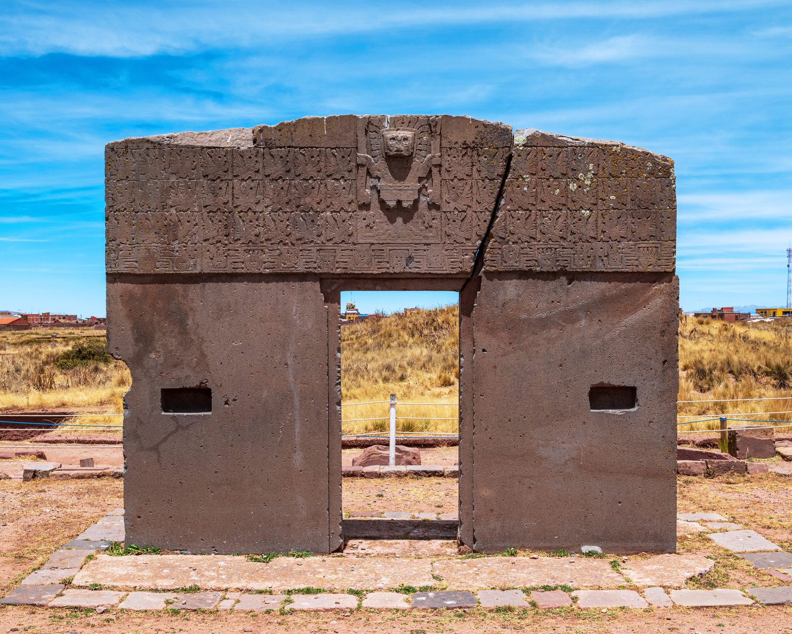
- Gateway of the Sun: monolithic andesite arch, single block approximately 10 tonnes; decorated with the Staff God (Viracocha), 48 winged attendant figures
- Pumapunku: separate ceremonial platform; H-shaped modular stone blocks cut to tolerances of fractions of a millimetre without iron tools
- Agriculture: suka kollus (raised-field system) sustained hundreds of thousands of people on the lake-margin altiplano
- GPS: 16.5554 S, 68.6739 W
History
Tiwanaku began as a small village settlement around 300 BC near the southern shore of Lake Titicaca. Over the following millennium it grew into the capital of a state that at its height controlled a territory stretching from what is now northern Chile and northwestern Argentina through Bolivia and into southern Peru – sustained not by military force but by the export of a prestigious religious and artistic system, and by a sophisticated agricultural technology. The suka kollu – a system of raised planting beds separated by water-filled channels that moderated temperature, stored solar heat, and provided moisture through the night frosts that afflict the altiplano – allowed Tiwanaku to support a population of several hundred thousand in an environment that appears hostile to intensive agriculture. Remnants of the raised-field system still pattern the landscape around the site.
The architectural and iconographic program of Tiwanaku was one of the most coherent and influential in pre-Columbian history. The Staff God – a frontal deity standing with bent knees, holding a staff in each hand adorned with condor and puma heads, weeping tears that transform into serpents – appears on the Gateway of the Sun and on objects distributed across the entire extent of Tiwanaku cultural influence: textiles, ceramics, carved stone, and metalwork. When the Inca Empire absorbed the former Tiwanaku heartland in the 15th century, they adopted the Staff God as their creator deity Viracocha and the architectural language of Tiwanaku as a model for their own imperial construction. In this sense Tiwanaku shaped Andean civilisation not once but twice.
Around 1000 AD, the Tiwanaku Empire collapsed – apparently due to a prolonged drought that disrupted the lake levels and the agricultural system dependent on lake-margin moisture. The capital was abandoned, its population dispersed across the altiplano. The site was partially looted in the Spanish colonial period, when its dressed stone blocks were quarried for construction in nearby towns. Archaeological excavation began in the late 19th century and continues today under Bolivian and international teams.
What you see
The Tiwanaku archaeological zone contains several distinct monumental complexes. The Akapana is a stepped platform mound approximately 257 metres on a side and 17 metres high, originally faced with andesite slabs and interpreted as a sacred mountain; its complex internal drainage channels suggest ritual use of water in the structure itself. The Kalasasaya is a large ceremonial enclosure approximately 120 by 130 metres whose semi-subterranean court contains carved stone monoliths (the Bennett Monolith, now in a protective shelter, and the Ponce Monolith in situ). The main entrance of the Kalasasaya is formed by the Gateway of the Sun, now standing in its northwest corner after being moved from its original position.
The Gateway of the Sun is one of those objects that photographs fail to prepare you for: a monolithic arch cut from a single block of grey-green andesite, its upper register densely carved with a frieze of the Staff God in the centre flanked by 48 winged attendant figures arranged in three rows, their feet ending in condor claws. Below the frieze, the faces are carved with an intensity of detail remarkable for a culture without iron tools. The Pumapunku, a separate complex approximately 1 km southwest, is equally astonishing for different reasons: its H-shaped and I-shaped andesite blocks, each cut with extraordinary precision and designed to interlock like stone furniture, represent a level of stoneworking technology whose methods remain incompletely understood.
Practical information
- Location: 72 km west of La Paz, near the town of Tiwanaku (municipality of Tiwanaku, La Paz Department)
- Opening hours: Daily 09:00-17:00; closed on major Bolivian national holidays
- Entry: Entrance fee payable at the site; includes access to the site museum (Museo de Sitio) with original carved monoliths and artefacts
- Altitude warning: At 3,840 metres, altitude sickness (soroche) is a real risk for visitors arriving from sea level; acclimatise in La Paz (3,640 m) for at least 24 hours before visiting
- Duration: Allow 3-4 hours for site + museum; serious archaeology visitors should allow a full day
- Best season: May-October (dry season); rainy season (November-April) makes paths muddy but the landscape is vivid green
Getting there
From La Paz, minibuses (minivans) to Tiwanaku depart from the cemetery district (Cementerio) in El Alto, approximately every 30-60 minutes; journey time 1.5-2 hours. Taxis and private transfers from La Paz are available and commonly organised through hotels. Many tour operators in La Paz offer half-day or full-day tours combining Tiwanaku with a stop at Lake Titicaca. Driving: take the route via El Alto and the Pan-American Highway (Highway 1) west toward Desaguadero; the Tiwanaku turn-off is clearly signposted. GPS: 16.5554 S, 68.6739 W.
Nearby
- Lake Titicaca – the world’s highest navigable lake at 3,812 metres, 30 km north of Tiwanaku; Isla del Sol (Island of the Sun) at the lake’s Bolivian side was sacred to the Inca as the birthplace of the Sun
- Puma Punku – the separate Pumapunku ceremonial platform at Tiwanaku, approximately 1 km from the main site; the H-shaped modular stone blocks are the most technically astonishing stonework at the site
- La Paz – the de facto capital of Bolivia, 72 km east; UNESCO Creative City of Gastronomy, with the witches’ market, cable car system, and Museum of Ethnography and Folklore
- Desaguadero – the Bolivia-Peru border crossing on Lake Titicaca, 20 km west of Tiwanaku; gateway to Puno (Peru) and the Peruvian shore of the lake
Sources
- UNESCO World Heritage – Tiwanaku: Spiritual and Political Centre of the Tiwanaku Culture (2000)
- Janusek, J. W. (2008). Ancient Tiwanaku. Cambridge University Press.
- Kolata, A. L. (1993). The Tiwanaku: Portrait of an Andean Civilization. Blackwell.
- Vranich, A. (1999). “Interpreting the Meaning of Ritual Spaces: The Temple of Pumapunku, Tiwanaku, Bolivia.” PhD dissertation, University of Pennsylvania.
- Bolivian Ministry of Culture – Centro de Investigaciones Arqueologicas de Tiwanaku
Find it on the map
See this place and what’s around it →📷 Diventa un fotografo di Cultural Heritage Online
Condividi le tue foto dei luoghi: restano pubblicate con la tua firma come autore. Più vengono viste, più ti fai conoscere — e presto un concorso premierà le foto più apprezzate.
Accedi o registrati gratis per aggiungere una foto