Portobelo–San Lorenzo: Spanish Colonial Fortifications
The most important surviving group of Spanish colonial fortifications in the Americas — a chain of Caribbean coast artillery bastions that once guarded the world’s greatest silver-shipping route. UNESCO World Heritage Site since 1980.
At a glance
Two fortified harbour complexes — Portobelo on a deep-water Caribbean bay, and San Lorenzo at the mouth of the Chagres River — formed the twin gatekeepers of the Camino Real, the overland route across the Isthmus of Panama along which Spain shipped all the gold and silver of Peru and Bolivia to the Atlantic world. Founded in 1597 CE, they remained strategically vital for 150 years, seeing off pirate raids by Francis Drake, sackings by Henry Morgan, and naval assaults by Admiral Edward Vernon. Their thick masonry bastions, gun platforms, and underground magazines are among the largest 17th-century fortification complexes in the Western Hemisphere.
Key facts
- UNESCO designation: World Heritage Site, 1980 — “Fortifications on the Caribbean Side of Panama: Portobelo-San Lorenzo”
- Founded: 1597 CE (Portobelo founded to replace Nombre de Dios; San Lorenzo built same year at the Chagres River mouth)
- Location: Portobelo, Colón Province, Panama (9.5570°N, 79.6497°W); San Lorenzo 30 km west
- Period of strategic importance: 1597–1739 CE; trade fairs held 1628–1739
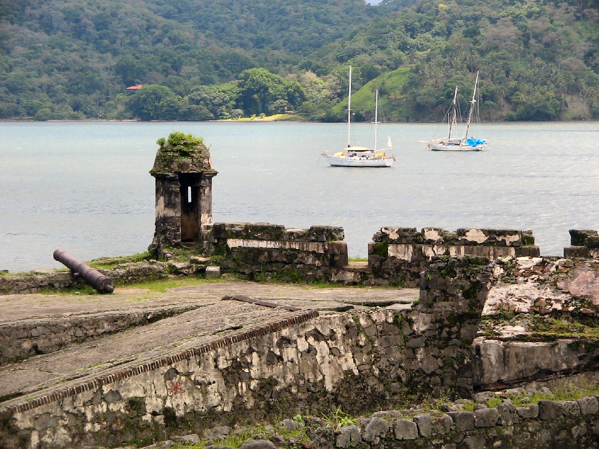
- Key structures at Portobelo: Fort San Jerónimo, Fort Santiago, Iron Castle (Castillo San Felipe), Fort San Fernando, Real Aduana (Customs House)
- Key structures at San Lorenzo: Fort San Lorenzo (rebuilt 1680s); commanding position above the Chagres River gorge
- Trade fair scale: Up to 50 ships at a time; silver, emeralds, diamonds, hides — the largest commercial event of the 17th-century world
- Current threats: Flooding, vegetation encroachment; on UNESCO’s “in danger” register since 2012
History
The isthmus of Panama was Spain’s most critical chokepoint in the entire American empire. All the wealth extracted from the mines of Potosí and Peru was carried by mule train across the mountains to Portobelo, then loaded onto the Atlantic-bound treasure fleet for shipment to Seville. Portobelo was founded in 1597 CE by Francisco Velarde de Mercado to replace the fever-ridden port of Nombre de Dios as the Caribbean terminus of this route.
Francis Drake, who had raided Nombre de Dios in 1572, died at sea off Portobelo’s entrance in January 1596 CE — just as Spanish engineers arrived to design the new port. Henry Morgan, the Welsh buccaneer, sacked Portobelo in 1668 CE despite its formidable defences, holding the city for ransom. In 1671 CE Morgan also stormed and destroyed San Lorenzo fort on his way to sack Panama City itself. San Lorenzo was rebuilt to an even stronger polygonal design in the 1680s.
The trade fairs held at Portobelo between 1628 and 1739 were the economic centrepiece of the Spanish empire. Convoys of galleons met the annual mule trains here; the bay would fill with 30–50 ships while merchants from across Spanish America traded in the city’s plazas. The system ended abruptly in 1739 when Admiral Edward Vernon of the British Royal Navy captured Portobelo with just six ships — a humiliation that ended the galleon trade and shifted Spain’s commercial routes around Cape Horn. Vernon named his estate “Portobello” in Middlesex — which in turn gave its name to Portobello Road in London.
What you see
At Portobelo, four fortress complexes are arranged to provide overlapping fields of fire across the bay. Fort San Jerónimo (substantially rebuilt 1753) is the best preserved, its cannon platforms intact and overlooking the customs house plaza. Fort Santiago occupies a peninsula on the southern shore. The Iron Castle (Castillo San Felipe) guards the northern approach; Fort San Fernando stands on a small island. Between them, the 17th-century Real Aduana (Customs House) — where the silver was weighed and taxed before shipment — is one of the finest Spanish colonial civic buildings in Central America and has been partially restored.
San Lorenzo fort stands 30 km west on a spectacular headland above the Chagres River gorge. Rebuilt after Morgan’s 1671 sack into a compact polygonal bastion with dry ditches and a drawbridge approach, it commands a panoramic view over the river mouth and the Caribbean. The U.S. Army used it as a training facility during the 20th century; the jungle has begun to reclaim its walls, giving it a dramatic, half-ruined character unlike the more maintained Portobelo sites.
Practical information
- Access: Portobelo town is 98 km from Panama City via the Transistmica highway; the drive takes 1.5–2 hours. San Lorenzo is best reached by 4WD vehicle via the former Fort Sherman road or by organised day tour from Panama City.
- Entry: Portobelo fortifications: the exterior is free. The Customs House museum charges a small fee. San Lorenzo: free entry.
- Opening hours: Portobelo is effectively open-air and accessible at most times. Customs House museum: approximately Tue–Sun 9:00–17:00 (verify locally before visiting).
- Best time to visit: Dry season, January–April. The Caribbean coast of Colón Province receives over 3,000 mm of rain annually — one of the wettest regions in the Americas.
- Safety: Avoid transiting Colón city. Take a direct bus or taxi from Panama City to Portobelo, or join an organised tour.
Getting there
From Panama City, take the Corredor Norte expressway toward Colón, then follow the Transistmica highway signs for Costa Arriba toward Portobelo. Buses leave from Panama City’s Albrook terminal; change at Sabanitas for Portobelo. Journey time: approximately 2 hours by public transport. For San Lorenzo, hire a car or join a day tour from Panama City — the route passes the Gatún Locks of the Panama Canal, which makes a worthwhile additional stop.
Nearby
- Gatún Locks, Panama Canal (30 km west): the Atlantic locks of the Canal, with a visitor centre and observation deck overlooking ships transiting between ocean levels.
- Nombre de Dios (70 km east): the earlier Spanish port that Portobelo replaced; a small town with remnants of the original Camino Real cobblestones.
- Panamá Viejo and Casco Antiguo (Panama City, 98 km south): the UNESCO-listed ruins of the original Panama City and the preserved colonial district — the Pacific terminus of the Camino Real that began at Portobelo.
Sources
- UNESCO World Heritage List: Fortifications on the Caribbean Side of Panama: Portobelo-San Lorenzo, 1980 — whc.unesco.org/en/list/135
- UNESCO in Danger listing, 2012 — whc.unesco.org/en/list/135/documents
- Wikipedia: “Portobelo, Colón” — en.wikipedia.org/wiki/Portobelo,_Col%C3%B3n
- Wikipedia: “Battle of Portobelo (1739)” — en.wikipedia.org/wiki/Battle_of_Portobelo_(1739)
Find it on the map
See this place and what’s around it →📷 Diventa un fotografo di Cultural Heritage Online
Condividi le tue foto dei luoghi: restano pubblicate con la tua firma come autore. Più vengono viste, più ti fai conoscere — e presto un concorso premierà le foto più apprezzate.
Accedi o registrati gratis per aggiungere una foto