I Portici di Bologna — 62 km di Arcate Medievali: la Città Coperta (UNESCO 2021)
A city that built itself a continuous roof — 62 kilometres of covered walkways, arched in stone and brick from the eleventh century to the nineteenth, that allow a resident of Bologna to walk from one end of the historic centre to the other without getting wet, from the two towers to the university, from the market to the church, under an unbroken canopy that constitutes the most extensive covered pedestrian network in any Italian city and, since 2021, the only urban portico system inscribed on the UNESCO World Heritage List.
At a glance
The porticoes of Bologna are a system of covered walkways supported on columns or piers, extending for approximately 62 kilometres through the historic city (38 km in the UNESCO-inscribed historic centre) and for an additional 3.8 km up the hill of the Colle della Guardia to the Santuario della Madonna di San Luca. The oldest porticoes date from the eleventh century (the earliest surviving examples are from approximately 1100); the construction of porticoes was regulated and made compulsory in the central streets by municipal statutes from the twelfth century; the portico of San Luca was built between 1674 and 1793. The UNESCO World Heritage inscription (2021, ref. 1650) covers 12 portico sections in the historic centre of Bologna, selected as representative of the variety of portico types and periods.
Key facts
- Total length: approximately 62 km of historic porticoes in the city of Bologna (38 km in the historic centre); no other Italian city has a comparable urban portico network
- Oldest examples: ca. 1100–1200 CE (Romanesque, wood columns on stone bases; none fully intact); the earliest surviving brick arched porticoes are XIII century
- Legal requirement: Municipal statutes from 1288 required all new buildings in the historic centre to have a ground-floor portico of minimum 7 Bologna feet (approximately 2.66 m) height; this statute was applied continuously to 1875
- Portico di San Luca: 3,796 m; 666 arches; begun 1674; completed 1793; runs from the city gate (Porta Saragozza) to the Santuario della Madonna di San Luca on the Colle della Guardia (289 m altitude); the longest portico in the world
- Types: Romanesque (round arches, stone columns, XIII century); Gothic (pointed arches, XIV–XV century); Renaissance (round arches, brick pilasters, XV–XVI century); Baroque (wider spans, XVII–XVIII century); Neoclassical (stone columns, XIX century)
- UNESCO: 2021, ref. 1650 — “The Porticoes of Bologna”
- GPS: 44.4938, 11.3430 — Google Maps
History
The origin of the Bolognese portico tradition is economic and pragmatic: in a medieval city growing rapidly beyond its walls, building outward was prohibited but building upward was encouraged, and the extension of upper floors over the public street — a standard medieval urban practice — required ground-level supports. These supports, which took the space of public pedestrian path, were gradually regularised: the municipality accepted the loss of ground-level space in exchange for the weather protection they provided, and from the twelfth century actively legislated for their continuation. The 1288 municipal statute that required porticoes on all new central-city buildings was the key moment: from this point, the portico ceased to be an ad hoc building element and became a civic norm — a continuous covered pedestrian network whose maintenance was a municipal responsibility.
The economic function of the porticoes was also important: in a trading city, the ability to move through the city in all weathers without losing time to rain or snow was commercially valuable, and the porticoes allowed markets and commerce to function continuously. Bologna is the centre of the Po plain and receives significantly more rain than most Italian cities (700mm/year, concentrated in autumn and spring); the porticoes are thus a functional response to climate as much as an aesthetic tradition.
What you see
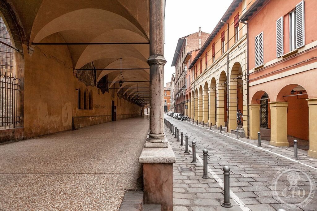
The experience of the porticoes is urban and ambient rather than monumental: it is more useful to walk through them than to go to a specific one. The central route (Via dell’Indipendenza from Bologna Centrale to Piazza Maggiore, then Via Rizzoli to the Due Torri — approximately 1.5 km) takes you through three different portico types: the nineteenth-century stone columns of Via dell’Indipendenza, the wide Baroque arches of Via Rizzoli, and the lower medieval arches of Via Zamboni (continuing to the university area). The visual effect of the sequence is one of variation within unity: the line of the arches continues, but the rhythm, the height, and the texture change from block to block.
The most spectacular single element is the Portico di San Luca: to experience its full length requires starting at Porta Saragozza (in the south-west section of the medieval walls) and walking 3.8 km uphill to the sanctuary. The portico begins in the city, passes through the suburban fringe, then climbs through olive groves and farmland to the hilltop sanctuary — a transition from urban to rural that is unlike any other walk in Italy. Allow 1.5–2 hours for the ascent; the descent (to the same point) takes approximately 1 hour.
Gallery
Practical information
- Historic centre porticoes: Always open; free; accessible 24 hours. The central network (from Bologna Centrale to Piazza Maggiore and Via Rizzoli to the Due Torri) is the easiest introduction.
- Portico di San Luca: Always open; free (the sanctuary entrance is free but timed visits to the upper chapels may require a reservation). Best visited on a clear day for the view from the sanctuary terrace; avoid summer midday (the portico is mostly in full sun on the south-facing upper slope).
- Museo della Storia di Bologna (Palazzo Pepoli): Via Castiglione 8; covers the full urban history of Bologna including the porticoes; open Tuesday–Sunday 10:00–19:00; admission ~€10.
- Duration: 30 minutes for a portico walk in the historic centre (Via dell’Indipendenza + Via Rizzoli circuit); 3 hours for the full Portico di San Luca round trip.
Getting there
Bologna, Emilia-Romagna. The portico network begins from Bologna Centrale FS station (from which the porticoes of Via dell’Indipendenza lead directly to Piazza Maggiore, 1.5 km). By train: very frequent connections from Milan (1h Freccia), Venice (1h35 Freccia), Florence (35 min Freccia), Rome (2h10 Freccia). By car: A1/A13/A14 all exit at Bologna; the historic centre is a ZTL zone (no private cars); park at Autostazione or Arena del Sole and walk. Bologna Centrale is one of the most connected stations in Italy.
Nearby
- Due Torri — 300 m east of Piazza Maggiore; the two leaning medieval towers (Asinelli 97m, 1109; Garisenda 48m, 1110); the Asinelli is climbable (498 steps, open daily); the best view of the porticoed streets from above
- Santuario della Madonna di San Luca — 3.8 km (Portico di San Luca, 666 arches); Baroque sanctuary (1723–1774) on the hill; the fresco of the Byzantine Madonna, one of the most venerated Marian images in Italy; panoramic view of the Po plain and the Apennines from the sanctuary terrace
- Palazzo dell’Archiginnasio — 100 m from Piazza Maggiore; the first purpose-built university building in Europe (1563); 6,000 heraldic stemmi; Teatro Anatomico (1637)
Sources
- UNESCO: whc.unesco.org/en/list/1650
- Wikipedia EN: Porticoes of Bologna
- Roversi, Giancarlo: I Portici di Bologna, Grafis, 1975
- Comune di Bologna: comune.bologna.it/portici
Find it on the map
See this place and what’s around it →📷 Diventa un fotografo di Cultural Heritage Online
Condividi le tue foto dei luoghi: restano pubblicate con la tua firma come autore. Più vengono viste, più ti fai conoscere — e presto un concorso premierà le foto più apprezzate.
Accedi o registrati gratis per aggiungere una foto