Plitvice Lakes National Park
The most beautiful lake system in Europe and the most visited national park in Croatia — Plitvice Lakes is a geological wonder of 16 turquoise travertine lakes connected by cascades and waterfalls in a primeval beech and fir forest, where the natural calcium carbonate barriers between the lakes are actively growing, making Plitvice one of the few landscapes in the world that is visibly, measurably changing shape over a human lifetime.
At a glance
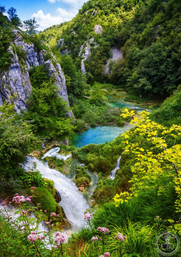
The Plitvice Lakes National Park (UNESCO WHS 1979; 296 km² total park area, of which approximately 2 km² is lake surface; the Mala and Velika Jezera (Lower and Upper Lakes) systems connected by the Veliki Prštavac waterfall) is located in the Dinaric karst region of central Croatia (the Lika area), approximately 130 km south of Zagreb; the 16 lakes are arranged in a north-south chain approximately 8 km long; the Gornja jezera (Upper Lakes) system consists of 12 larger, shallower lakes in a widening valley; the Donja jezera (Lower Lakes) system consists of 4 smaller, deeper lakes in a narrowing canyon; the Sastavci (Confluence; the point where the two lake systems meet at the head of the canyon; the Veliki Slap falls directly below it) is the visual climax of the park; the entire lake system is fed by the Crna Rijeka (Black River) and the Bijela Rijeka (White River), which join above the Upper Lakes; the water colour (which varies from turquoise to green to blue depending on the mineral content, the depth of the water, and the light conditions) is caused by dissolved calcium carbonate, magnesium carbonate, and other minerals; the travertine barriers that create the lakes are formed by the precipitation of calcium carbonate around the mosses and algae growing in the water — a living process that creates a constantly changing landscape; the park contains approximately 1,267 plant species, 321 bird species, and large populations of brown bear, wolf, lynx, and wild boar.
Key facts
- The travertine formation process: one of the most active travertine environments in the world — travertine (also called tufa; the mineral form of calcium carbonate (CaCO₃) deposited in freshwater environments; the same material that Roman builders used for construction and that natural springs have created at hot springs in places like Hierapolis-Pamukkale in Turkey and Mammoth Hot Springs in Yellowstone) at Plitvice is formed by a specific combination of factors: the water temperature (approximately 8–12°C, cold enough to hold dissolved CO₂); the velocity of the water (fast enough to degas CO₂ when the water slows at the lake edge); and the presence of specific microorganisms (the cyanobacterium Phormidium incrustatum and several species of aquatic moss) that create the nucleation sites for calcium carbonate deposition; the barriers grow at a rate of approximately 1 cm per year (rapidly by geological standards); in some areas, new barriers are forming in front of existing ones, creating new proto-lakes; in other areas, existing barriers are being eroded; the net result is that the shape of the park is visibly different from photographs taken 100 years ago and will be different again in 100 years
- The wildlife: one of the last strongholds of large carnivores in central Europe — Plitvice National Park and the surrounding Dinaric karst forests form part of the largest connected predator habitat in central and south-eastern Europe; the park supports approximately 50–80 brown bears (Ursus arctos; the species’ last significant population in Croatia; the bears are shy and rarely seen by visitors, though tracks are common; the park is a breeding and dispersal source for bears in the wider Dinaric-Pindos population); approximately 40–70 wolves (Canis lupus; the Dinaric-Balkan wolf population is the largest in south-eastern Europe and one of the primary sources for the recolonisation of central Europe by wolves); and a smaller population of Eurasian lynx (Lynx lynx; reintroduced to the Dinaric mountains from Czechoslovakia in 1973; one of the few successful large carnivore reintroductions in Europe); the larger wildlife is most active at dawn and dusk in the areas of the park away from the main boardwalk routes (the Labudovac Plateau area and the trails toward Prošćansko jezero are the quietest sections)
- The wartime period: the most significant recent chapter in the park’s history — the park was the site of the first armed conflict of the Croatian War of Independence (31 March 1991; the “Battle of the Plitvice Lakes” (Plitvički incident); Croatian police and Serb paramilitaries engaged in a skirmish on the shores of the lakes; one Croatian policeman (Josip Jović) was killed — the first Croatian casualty of the war; the park was under Serbian control from April 1991 to August 1995 (the area was part of the self-declared Republic of Serbian Krajina); UNESCO placed the park on the World Heritage in Danger list in 1992; during the wartime period, the boardwalk infrastructure was largely destroyed, many animals were killed, and illegal logging occurred in the surrounding forests; the park was returned to Croatian control after Operation Storm in August 1995 and removed from the Danger list in 1997 following restoration work
- Heritage: UNESCO World Heritage Site, Plitvice Lakes National Park, inscribed 1979
- GPS: 44.8803° N, 15.6164° E
History
The Plitvice Lakes area was inhabited from Neolithic times; the first written description of the lakes was made by the Franciscan friar Stjepan Matijević in 1777; the area attracted tourists from the late 19th century (the first hotel was built in 1896); national park status was declared in 1949 (one of the first national parks in Yugoslavia); UNESCO WHS 1979 (one of the first inscriptions under the World Heritage Convention); the park was placed on the World Heritage in Danger list during the Croatian War of Independence (1991–1995); restored and expanded in the post-war period; the park now faces challenges from mass tourism (the boardwalks are crowded to dangerous levels in July–August) and from climate change (the reduced snowmelt has lowered water levels).
What you see
The park is organised into two main circuits (Rute/Routes 1–8 at different lengths from 2 km to 18 km; the most popular routes are Routes H (8 km; covers both Upper and Lower Lakes; 4–6h; the full experience) and Route C (4 km; covers the Lower Lakes only; 2–3h; the most photogenic section)); the boardwalk system (approximately 18 km of wooden boardwalks built directly over the water and alongside the lake edges; the boardwalks are the defining experience of the park — you walk across and through the waterfalls at water level, with the turquoise water visible directly below your feet; the boardwalk narrows to single-file width in the most dramatic sections and is busy enough in summer to require a one-way walking direction); the Veliki Slap (the Big Waterfall; 78 m; the highest in Croatia; accessible by a short trail from Entrance 1 at the Lower Lakes); the electric boat across Jezero Kozjak (the largest lake; 82 hectares; 46 m deep; the crossing by flat-bottomed electric boat takes 10 min; included in the park ticket).
Practical information
- Tickets and crowds: the park has strict capacity controls and requires advance booking in peak season — park entrance tickets (Entrance 1 for the Lower Lakes (nearest to Route C and the Veliki Slap); Entrance 2 for the Upper Lakes (nearest to Routes A–F and the most scenic sections of the Upper Lakes)); prices approximately HRK 200–350 (EUR 25–45; varies by season: low January–March, high July–August); in July–August the boardwalks in the Lower Lakes section are genuinely overcrowded (shoulder-to-shoulder in the narrowest sections; 15,000+ visitors per day at peak); timed-entry and booking has been introduced (tickets available at np-plitvicka-jezera.hr; the first entry time (8am) is the best for crowds and light); shoulder season (April–June, September–October) is the recommendation — the waterfalls are fuller after rain and snowmelt in spring, the autumn foliage turns the beech forest gold in October
- Getting there: the park is approximately 130 km south of Zagreb (2h by road; the A1/E71 motorway to the Plitvice exit; the last section from the motorway exit is through the Mala Kapela mountain pass) and approximately 240 km north of Dubrovnik (3h by road; the D1 national road through the Lika region); from Zagreb: numerous bus connections from the Zagreb main bus station (Autobusni kolodvor; the Autotrans and Slavonija Sano bus companies run direct services to Entrance 1 (Rastoke) and Entrance 2 (Mukinje); 2h–2h 30 min; approximately EUR 8–15 one way); there is no railway station at the park; the nearest station is Ogulin (40 km north; the main line from Zagreb to Split); car or bus are the primary options
- Accommodation: staying in the park area overnight transforms the experience — the park operates 4 hotels (Hotel Jezero; Hotel Plitvice; Hotel Bellevue; Hotel Grabovac) within or immediately adjacent to the park boundaries; they are expensive by Croatian standards (EUR 120–250 per room in high season) but allow visitors to enter the park at 7am before the day-trippers arrive from Zagreb and Split; the surrounding villages (Rastovača, Mukinje, Plitvička Jezera, Smoljan) have a large supply of family-run sobe (rooms) and apartments at EUR 40–80 per night; the most affordable strategy for a 2-day visit
Getting there
Bus from Zagreb (2h, EUR 8–15) or Dubrovnik (3h). No train. Car from Zagreb 130 km via A1 motorway. GPS: 44.8803, 15.6164.
Nearby
- Rastoke — 25 km north of Plitvice (30 min by road); the most beautiful village in Lika — Rastoke (a village of approximately 200 people at the confluence of the Slunjčica River and the Korana River; the mills (mlini) of Rastoke have been in operation since the 17th century; the Slunjčica River falls over the village’s edge in a series of waterfalls (the “small Plitvice of Rastoke”) directly between and under the houses; the sound of water is constant from every point in the village; the water-mills still operate and can be visited; the village has about 10 family restaurants/konoba serving local trout, lamb, and smoked meats; the most authentic lunch stop in the Lika area)
- Krka National Park — 170 km south of Plitvice (2h 30 min by road; 50 km north of Split; near the town of Šibenik); the second most visited national park in Croatia and the primary alternative to Plitvice — Krka National Park (the Krka River canyon; the Skradinski buk waterfall (17 cascades; the most famous waterfall in the park; formerly permitting swimming in the pools (banned 2021); the boat trip from Skradin to Skradinski buk takes 30 min by river through the canyon; the Visovac Island (a tiny island with a Franciscan monastery in the middle of the Visovac Lake, the widening of the canyon behind Skradinski buk; the monastery dates to 1445 and houses an important collection of historic documents including a 1495 edition of Aesop’s Fables); the Roski slap (a second waterfall system; less visited; quieter; recommended for those who want to avoid the Skradinski buk crowds))
- Zadar — 160 km south of Plitvice (2h 30 min by road; on the Dalmatian coast); the most interesting coastal city in northern Dalmatia and the site of Alfred Hitchcock’s “best sunset in the world” declaration — Zadar (a Roman city (Zadar Forum; 1st century BC; the column of shame; well preserved Roman remains); the Sea Organ (Morske Orgulje; a 70-metre underwater architectural organ installation by Nikola Bašić (2005); air pushed through the marble steps at the sea edge by the wave motion produces a constant, variable, and completely organic musical sound from the perforated steps; the most beautiful public art installation on the Adriatic coast); the Greeting to the Sun (Pozdrav Suncu; a 22-m diameter glass disc installation by the same artist adjacent to the Sea Organ; it harvests solar energy during the day and produces a light show at night using the stored energy; the combination of the Sea Organ sound and the Greeting to the Sun light display at sunset is what Hitchcock was referring to (though he visited Zadar before these installations were built; the sunset itself has always been famous)))
Sources
- Wikipedia, Plitvice Lakes National Park; Travertine (Plitvice); Battle of Plitvice Lakes, accessed June 2026
- UNESCO, Plitvice Lakes National Park, WHS reference 98, inscribed 1979
- Croatian Ministry of Nature Conservation, National Park Plitvice: Management Plan 2019–2028, Zagreb, 2019
Find it on the map
See this place and what’s around it →📷 Diventa un fotografo di Cultural Heritage Online
Condividi le tue foto dei luoghi: restano pubblicate con la tua firma come autore. Più vengono viste, più ti fai conoscere — e presto un concorso premierà le foto più apprezzate.
Accedi o registrati gratis per aggiungere una foto