Perugia
An Etruscan-founded city of art perched on a dramatic hilltop acropolis, Perugia remains one of Italy’s most characterful medieval centers, its historic core spread across five gates and crowned by the Porta Sole at nearly 500 meters above sea level.
At a glance
Perugia is a major cultural and university center in Umbria, commanding the landscape from an acropolis roughly 450 meters above sea level. The historic center maintains its medieval character, arranged asymmetrically across a series of hills with a principal north-south axis of three kilometers. New neighborhoods extend into the valleys below, while the municipality sprawls across nearly 450 square kilometers of green areas and fields.
History
The Etruscans founded Perugia, leaving an original defensive wall of approximately three kilometers. In the thirteenth and fourteenth centuries, a substantially expanded nine-kilometer fortification was constructed, enclosing an area of 120 hectares. This medieval enlargement defined the city’s current boundaries and reflects the period of Perugia’s rise as a regional power. The five medieval villages within the historic center, each developed around a gate, exemplify the organic growth of the medieval city.
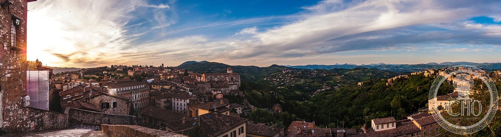
What you see
The city’s most distinctive feature is its topography—the highest point, Porta Sole, reaches 494 meters, making Perugia the most populated Italian city above 250 meters altitude. The historic center develops along ridge lines, forming a linear structure rather than a circular plan. Medieval gates punctuate the defensive walls, and the city’s characteristic steep streets and staircases connect the ridge-top neighborhoods with the valleys below.
Cultural significance
Perugia functions as a regional cultural, productive, and administrative center, hosting a university and serving as an international tourist destination. Its harmonious medieval appearance and vast historic district represent a major example of Italian civic organization and defensive strategy from the Middle Ages.
Key facts
- Founded by the Etruscans
- Historic center occupies an acropolis approximately 450 m above sea level
- Highest point (Porta Sole): 494 m
- Municipal area: 449.51 km²
- Medieval walls: approximately 9 km (13th–14th centuries)
- Etruscan walls: approximately 3 km
- Address: Corso Vannucci 19
- Coordinates: 43.094997, 12.3102843
- Phone: 075 5771
- Website: http://www.comune.perugia.it/
Practical information
Perugia is an active university city with comprehensive visitor facilities. The historic center contains numerous hotels, restaurants, and shops concentrated around Corso Vannucci, the principal street. Street parking within the old town is limited; most visitors use public car parks at the base of the acropolis and escalators to ascend into the center.
Getting there
Perugia lies in central Umbria. Direct rail connections link the city to Rome, Florence, and other major centers; the main station is located in the lower town with escalators and elevators providing access to the historic center. Regional road networks connect Perugia to surrounding Umbrian towns and highways to neighboring regions.
Sources & resources
Find it on the map
See this place and what’s around it →Historical events at this place (4)
📷 Diventa un fotografo di Cultural Heritage Online
Condividi le tue foto dei luoghi: restano pubblicate con la tua firma come autore. Più vengono viste, più ti fai conoscere — e presto un concorso premierà le foto più apprezzate.
Accedi o registrati gratis per aggiungere una foto