

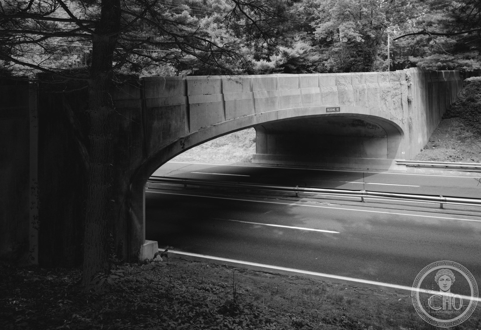
Forty-four unique Art Deco bridges — each one different, none repeated — distinguish this Depression-era scenic highway through southern Connecticut, the most ornamented stretch of road in New England.
At a glance
The Merritt Parkway runs 37.5 miles through Fairfield County and a corner of New Haven County, connecting Greenwich at its western end to Orange near New Haven at its east. Built between 1934 and 1940 under a combination of state and federal funding, the parkway was designed from the outset as a scenic alternative to congested US Route 1. Its 44 bridges, each uniquely designed by George Dunkelberger of the Connecticut State Highway Department, give the road an architectural identity found nowhere else in American highway engineering: an unbroken sequence of Art Deco concrete spans, varying in profile, ornament, and scale, strung along a landscaped right-of-way planted to recall a natural corridor through the Connecticut countryside.
Key facts
- Opened: Partial opening July 3, 1938; final section completed 1940
- Length: 37.5 miles (60 km), Fairfield County and New Haven County
- Bridges: 44 unique bridge designs by George Dunkelberger, Connecticut State Highway Department
- Named after: Schuyler Merritt, US Representative from Connecticut
- Design rules: No commercial trucks, no billboard advertising, landscaped median
- Designation: National Register of Historic Places (1991), National Scenic Byway
- Route: Connecticut Route 15
History
By the early 1930s, US Route 1 through southwestern Connecticut had become one of the most congested roads in the northeastern United States — a strip of gas stations, tourist cabins, and roadside stands that the automobile had conjured from what had been quiet farmland and coastal marsh. The state highway department’s response was to build a controlled-access parkway parallel to Route 1, reserved for passenger cars and protected from commercial development by a wide right-of-way. The concept drew from the Bronx River Parkway and Taconic State Parkway in New York: that a road could be a designed landscape, not merely a utilitarian channel.
George Dunkelberger, the Connecticut State Highway Department architect assigned to the bridges, saw the commission as an opportunity to demonstrate that infrastructure could have individual artistic character. He designed each of the 44 bridges differently — varying not just the arch profile and the pier dimensions but also the decorative cast-iron railings, the concrete bas-reliefs embedded in the wingwalls, and the spandrel ornament above the openings. The result is a sequential experience: driving the Merritt Parkway is, for anyone paying attention, a continuous encounter with Art Deco design, bridge by bridge, from Greenwich to New Haven.
The parkway opened in sections beginning July 3, 1938. The final section was completed in 1940. It was named in honor of Schuyler Merritt, the Stamford attorney and US Representative who had championed the highway’s funding in Congress. Listed on the National Register of Historic Places in 1991, the Merritt Parkway is now one of the most comprehensively studied pieces of New Deal transportation infrastructure in the United States.
What you see
The bridges are the experience. Each one presents a different face to the driver — some with bold concrete arches that frame a view of the sky, others with flatter profiles and elaborate cast-metal railings worked into geometric Art Deco patterns. The Redding Road Bridge in Fairfield, for example, has curved wingwalls bearing low-relief decorative panels, while the Guinea Road Bridge in Stamford has a dramatically different profile and entirely different decorative vocabulary. Dunkelberger evidently derived pleasure from the variation; the bridges feel like the output of a designer who was experimenting with the limits of the commission, not fulfilling a quota.
The parkway’s landscaping reinforces the bridges. The median strip was planted with native Connecticut species — dogwood, laurel, azalea — to give the road a forest-drive character in all seasons. The effect is of a road that has been inserted into the landscape rather than imposed upon it, a concept that was partly nostalgic (evoking the carriage drives of the preceding century) and partly progressive: a highway with an ecological conscience, in the language of the 1930s.
Practical information
- Access: Connecticut Route 15; passenger cars only (commercial vehicles prohibited)
- Tolls: E-ZPass tolls at multiple points along the route
- Best approach: Drive the full length westbound (Greenwich to Orange) in one direction to see all 44 bridges sequentially; allow 45–60 minutes without stops
- Speed limit: 55 mph; the parkway is a working highway, not a museum route
- Photography: Pull-offs at several bridge locations allow exterior photography; do not stop on the roadway
Getting there
The western terminus is accessible from Interstate 684 via exit in Greenwich, Connecticut. The eastern terminus is near New Haven, accessible from I-95 or I-91. From New York City, the parkway entrance at Greenwich is approximately 35 miles from Midtown Manhattan — typically a 45-minute drive via I-95 or the Hutchinson River Parkway. Metro-North Railroad serves Greenwich, Stamford, and Bridgeport along the New Haven Line, from which local transportation can reach various bridge locations.
Nearby
- Yale University Art Gallery (1953), New Haven — Louis Kahn’s first major commission, at the eastern end of the parkway route; the art gallery’s interior grid ceiling is one of the key works of mid-century American architecture
- Silvermine Arts Center, New Canaan — Artists’ community along the parkway corridor, founded 1908; one of the oldest arts centers in New England
- Weir Farm National Historic Park, Ridgefield — Home and studio of American Impressionist J. Alden Weir, preserved as a working artists’ retreat in a rural Connecticut setting
- Stamford Museum and Nature Center — Museum with a working farm, planetarium, and galleries in the Stamford area along the parkway
Sources
- Connecticut Department of Transportation, Merritt Parkway history, ct.gov/dot
- Historic American Engineering Record (HAER), Library of Congress, Merritt Parkway documentation
- Wikipedia, “Merritt Parkway,” en.wikipedia.org/wiki/Merritt_Parkway
- National Register of Historic Places nomination, Merritt Parkway, 1991, nps.gov/nrhp
Find it on the map
See this place and what’s around it →Record researched and written by Luigi De Marchi for Cultural Heritage Online, 2026.
📷 Become a Cultural Heritage Online photographer
Share your photos of places: they stay published under your name as the author. The more they're seen, the more you get noticed — and soon a contest will reward the most appreciated photos.
Log in or sign up free to add a photo